Weather Extremes - The Jet Stream - Unusually Hot Alaska

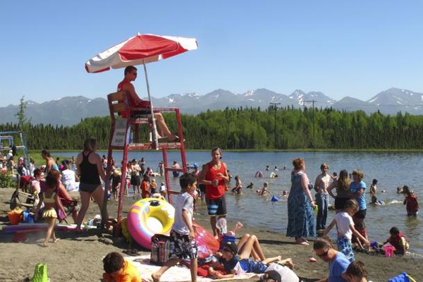
People swim and sunbathe at Goose Lake in Anchorage, Alaska on Monday, June 17, 2013. Alaska's largest city and other parts of the state are experiencing a long stretch of higher than normal temperatures.
Lately, the jet stream isn’t playing by the rules. Scientists say that big river of air high above Earth that dictates much of the weather for the Northern Hemisphere has been unusually erratic the past few years.
They blame it for everything from snowstorms in May to the path of Superstorm Sandy. And last week, it was responsible for downpours that led to historic floods in Alberta, Canada, as well as record-breaking heat in parts of Alaska. The town of McGrath, Alaska, hit 94. Just a few weeks earlier, the same spot was 15 degrees. The current heat wave in the Northeast is also linked.
The jet stream usually rushes rapidly from west to east in a mostly straight direction. But lately it’s been wobbling and weaving like a drunken driver, wreaking havoc as it goes. The more the jet stream undulates north and south, the more changeable and extreme the weather. It’s a relatively new phenomenon that scientists are still trying to understand. Some say it’s related to global warming; others say it’s not.
In May, there was upside-down weather: Early California wildfires fueled by heat contrasted with more than a foot of snow in Minnesota. Seattle was the hottest spot in the nation one day, and Maine and Edmonton, Canada, were warmer than Miami and Phoenix. Consider these unusual occurrences over the past few years:
— The winter of 2011-12 seemed to disappear, with little snow and record warmth in March. That was followed by the winter of 2012-13 when nor'easters seemed to queue up to strike the same coastal areas repeatedly.
— Superstorm Sandy took an odd left turn in October from the Atlantic straight into New Jersey, something that happens once every 700 years or so.
— One 12-month period had a record number of tornadoes. That was followed by 12 months that set a record for lack of tornadoes.
And here is what federal weather officials call a ‘‘spring paradox’’: The U.S. had both an unusually large area of snow cover in March and April and a near-record low area of snow cover in May. The entire Northern Hemisphere had record snow coverage area in December but the third lowest snow extent for May.
The jet stream, or more precisely the polar jet stream, is the one that affects the Northern Hemisphere. It dips down from Alaska, across the United States or Canada, then across the Atlantic and over Europe and has everything to do with the weather we experience. It all starts with the difference between cold temperatures in the Arctic and warmer temperatures in the mid-latitudes. The bigger the temperature difference, the stronger the jet stream, the faster it moves and the straighter it flows. But as the northern polar regions warm two to three times faster than the rest of the world, augmented by unprecedented melting of Arctic sea ice and loss in snow cover, the temperature difference shrinks. Then the jet stream slows and undulates more.
The jet stream is about 14 percent slower in the fall now than in the 1990s. And when it slows, it moves north-south instead of east-west, bringing more unusual weather, creating blocking patterns and cutoff lows that are associated with weird weather. Recently the jet stream seems to create weather patterns that get stuck, making dry spells into droughts and hot days into heat waves.
Take the past two winters. They were as different as can be, but both had unusual jet stream activity. Normally, the jet stream plunges southwest from western Washington state, sloping across to Alabama. Then it curves slightly out to sea around the Outer Banks, a swoop that’s generally straight without dramatic bends. During the mostly snowless winter of 2011-12 and the record warm March 2012, the jet stream instead formed a giant upside-down U, curving dramatically in the opposite direction. That trapped warm air over much of the Eastern U.S.
A year later the jet stream was again unusual, this time with a sharp U-turn north. This trapped colder and snowier weather in places like Chicago and caused nor'easters in New England. But for true extremes, nothing beats tornadoes.
In 2011, the United States was hit over and over by killer twisters. From June 2010 to May 2011 the U.S. had a record number of substantial tornadoes, totaling 1,050. Then just a year later came a record tornado drought. From May 2012 to April 2013 there were only 217 tornadoes - 30 fewer than the old record. Both examples were related to unusual jet stream patterns.
Last fall, a dip in the jet stream over the United States and northward bulge of high pressure combined to pull Superstorm Sandy almost due west into New Jersey. That track is so rare and nearly unprecedented that computer models indicate it would happen only once every 714 years, according to a new study by NASA.
No comments:
Post a Comment