Monday 30 September 2013

Earthquakes

Magnitude 5+ Earthquakes – Global

6.4 Earthquake hits the Kermedec Islands off New Zealand.

5.5 Earthquake hits the northern Mid-Atlantic ridge.

5.3 Earthquake hits Bio-Bio, Chile.

5.1 Earthquake hits Bio-Bio, Chile.

5.1 Earthquake hits the southeast Indian ridge.

5.1 Earthquake hits the Kuril Isalnds.

5.0 Earthquake hits Bio-Bio, Chile.

Storms and Floods

Tropical Storms

In the Atlantic:

Tropical depression Eleven is located about about 1070 mi (1725 km) ENE of the northern Leeward Islands. Had been expected to become a tropical storm Sunday. It should move in the general direction of the Gulf of Mexico. Tropical depression Eleven in the Central Atlantic will likely become Tropical storm Jerry today.

In the Western Pacific:

Typhoon Wulip is located about 157 nm east-northeast of Da Nang, Vietnam. Expected to reach coastal areas of Vietnam today.

Wulip, the 21st tropical storm of this year came into being in the Central part of the South China Sea. It will bring more than 7 grade gales to the east-central Guangdong coast of China and threaten the security of sea-related vessels and offshore work. It is expected that Wulip will move slowly at a speed of 5-10 km towards the west and the south sea surface of Hainan, its intensity strengthens gradually. Due to the joint influence of the cold air from Wulip and the southwest monsoon, there will be 6-7 level gales in Guangdong east-central coast. Wind force in the northern and central parts of the South China Sea is 8-9 grade and gusts are up to 10-11 grade.

Tropical depression Twenty-One is located about 634 nm southeast of Yokosuka, Japan.

Floods sweep across Southeast Asia

Thailand and Cambodia struck with floods leaving several dead. Heavy monsoon season has flooded 27 provinces in Thailand, killing nine and forcing evacuations in at least nine districts. Thousands fled their homes on army lorries with food and water in plastic bags. Streets have been turned into waterways and cars replaced by boats. Many of the residents are too scared to leave their homes. So far, about 1.5 million people from 420,000 households have been affected.

Elsewhere in Cambodia, floods have killed at least 20 and left more than 33,000 families affected. Approaching Typhoon Wulip will cause torrential downpours not only in Vietnam, but across the region, so the flooding is likely to get worse. The Chinese province's meteorological department on Saturday morning launched a grade three emergency response alert. The meteorological department have already warned local fishermen operating in the central area of South China Sea to dodge the storm centre and avoid outdoor activities until further notice.

NewsBytes:

Philippines - The death toll from monsoon rains rose to 31 on Saturday. The latest fatality died because of a landslide in Bauan, Batangas. Two others are still missing while eight were reported injured. The monsoon rain has so far affected 123,160 families, or 588,147 people, in 330 villages in 34 towns and 11 cities in seven provinces. Of these, 5,779 families or 25,087 people are staying in 103 evacuation centres.

At least twelve miners have been trapped in a coal mine in Shanxi province in China. The Zhengsheng Coal Mine, near to Fenyang City became flooded early Saturday. At least 30 other miners have been lifted out of the mine shaft.

Sunday 29 September 2013

Earthquakes

Magnitude 5+ Earthquakes – Global

5.0 Earthquake hits the Bougainville region, Papua New Guinea.

The 6.8 magnitude temblor that struck southwestern Pakistan on Saturday 96 kilometres northeast of the district of Awaran, killed at least 12 people in the same province where several hundred died on Tuesday from the 7.7 quake in which the quake toll has reached 515.

Storms and Floods

Tropical Storms

In the Atlantic:

Tropical depression Eleven is located about 960 mi (1540 km) ENE of the northern Leeward Islands. Expected to become a tropical storm today.

In the Western Pacific:

Typhoon Wulip is located about 240 nm east of Da Nang, Vietnam. Expected to reach coastal areas of Vietnam on Monday.

Wildlife

Migrating Monarch Butterflies Disappearing

Clusters of colourful monarch butterflies are now in the midst of their marathon migration southward across a broad swath of North America, but observers warn their numbers have plummeted again this year.

This year's reports indicate that the decline in monarch numbers over the past 10 to 15 years appears to have been much steeper this summer.

Biologist Jeremy Kerr told the Ottawa Citizen that he thinks numbers are now down by as much as 90 percent.

Loss of habitat and pesticide use due to expanding agriculture is mainly to blame, according to experts.

Last summer’s extreme drought in the U.S. corn belt wiped out huge numbers of milkweeds, which the monarchs need to breed and feed.

Elizabeth Howard of Journey North says that was a fatal blow to many of the iconic fliers.

Monarchs typically live only four to five weeks, except for the generation that emerges in late summer. That’s the one that migrates the entire way southward to the species’ wintering grounds in the Mexican state of Michoacan.

The small number of southward migrants this autumn has caused even more concerns over the long-term future of the world’s longest-migrating butterflies.

Ew130927a

Disease

HIV - Aids

HIV infection rate down 33 percent worldwide since 2001 - The global rate of new HIV infections among adults and children has fallen by 33 percent since 2001, according to a new report that touts major progress against HIV transmission to kids.

Drought

Drought Conditions - USA - Update

Texas Statewide Drought Could Last 15 Years

Despite the relief brought on by the recent rains across the Brazos Valley, the majority of the state remains in a drought. The Texas State Climatologist predicts the drought could last anywhere from 1 to 15 years.

Officials point to the area's water aquifer and the change of season as reasons such water restrictions are not required. It's not all bad news though. While 80 percent of the state remains in a drought, the amount of "extreme drought" in Texas is on the decline. Levels of "extreme drought" have dropped from 28 to 8 percent.

Corn Belt's drought woes won't end in 2013

There’s bad news for much of the nation’s heartland – the so-called “flash drought” won’t be leaving as quickly as it began. More than 50 percent of the Midwest is in varying levels of drought.

Drought in Iowa, especially the western half of the state, is slowly gaining momentum. Extreme drought returned to the nation’s leading corn and soybean producing state for the first time since April. More than 78 percent of the state is in moderate or worse drought. Minnesota, Wisconsin, Illinois and Missouri aren’t far behind.

The “U.S. Seasonal Drought Outlook” doesn’t see much improvement for much of the Corn Belt’s drought through the end of year, meaning for areas from Minnesota to Missouri won’t be free from drought in 2013. Along the western edge of the Corn Belt, however, drought conditions are slightly more favourable. Just 11 percent of Nebraska is in extreme drought, down from 21 percent last week.

While few farmers are excited to see drought, the drought did help save Nebraska rom flooding. Historic floods in Colorado moved into Nebraska this week, but before major flooding could sweep over the fields, drought-stricken land soaked up some of the floodwaters. These same floods that eliminated drought in north central Colorado bypassed much of the dry, southeast corner of the state. The worst of the drought currently persists in four counties in southeast Colorado, and it too is expected to persist into 2014.

Drought is keeping a firm grip on states further to the west. Little to no drought improvement was made this week in Idaho, Nevada, California and Oregon. Most of these states will also be seeing drought through the end of year.

Wildfires

Bushfires - Australia

A bushfire has broken out on Sydney's northern beaches, cutting access to an iconic lighthouse.

Volcanos

Roundup of Global Volcanic Activity:

Sakurajima volcano (Kyushu, Japan) activity update

Strong vulcanian explosion from Sakurajima in the afternoon of 27 Sep (08:24 UTC, 17:24 local time); ash plume reached 13,000 ft. Activity fluctuates on a scale of few days, but remains at relatively high levels overall. Explosions from the Showa crater often follow each other at intervals of few hours, and ash plumes regularly surpass 10,000 ft altitude (something that had been more rare during the past years). Most explosions are of vulcanian type (strong fragmentation of solid material blocking the vent, generation of tall ash plumes, often with shock waves and explosion sounds) and more rarely strombolian, with mainly incandescent lava ejected in fountains of several hundred meters and only little ash. Following most explosions, the volcano usually continues to near-constantly emit ash plumes of various size for several hours. These plumes, when observed during the past days, were up to about 500 m tall, with sometimes weak strombolian activity visible reaching above the crater rim.

Jebel Zubair (Red Sea, Jemen):

New submarine volcanic eruption A submarine eruption started yesterday (28 Sep) NW of the island Jebel Zubair and SW of the site of the 2011-12 eruption. The activity manifested itself in form of a strong SO2 anomaly and steam plume spotted on satellite imagery. No signs of activity are visible on images taken on 27 Sep, which confirms that the eruption started yesterday. The presence of the significant steam plume suggests that the eruption vent is a shallow depth (less than 100 m), and possibly in the stage of producing so-called surtseyan activity (violent steam-driven explosions breach the surface with jets of water and steam, and become more and more rich in lava fragments as the vent becomes shallower).

Saturday 28 September 2013

Earthquakes

Magnitude 5+ Earthquakes – Global

6.8 Earthquake hits Pakistan.

5.7 Earthquake hits Tonga.

5.1 Earthquake hits Tonga.

5.0 Earthquake hits the Solomon Islands.

5.0 Earthquake hits east of the South Sandwich Islands.

Storms and Floods

Tropical Storms

In the Atlantic:

An area of low pressure east of the Lesser Antilles over the central Atlantic (Invest 96-L) is battling strong winds aloft around a nearby upper low. The upper low will move in tandem with 96-L and should be slow to weaken. This will inhibit significant development for at least the next day or two. Regardless of organization, 96-L will move northward and eventually northeastward and poses no threat to the U.S.

In the Western Pacific:

Tropical Storm Wutip is still on track to head to Vietnam as an intensifying typhoon by early next week, then head inland over Laos and Thailand with a threat of heavy rainfall.

NewsBytes:

Flooding in Cambodia has claimed the lives of at least 23 people in the last two weeks, and has affected about 56,900 families in seven different provinces.

A dust storm has closed a 14-mile stretch of a state highway in the Casa Grande, Arizona, USA for nearly three hours. According to the Arizona Department of Transportation, low visibility and the multiple car crashes forced the closure of road. Gusty winds dropped visibility to less than 1 mile.

Wildlife

Report Reveals Cause of Massive Madagascar Whale Stranding

Sometimes good science takes time. This week, more than five years after the fact, a report was released about a mysterious mass stranding of whales that made international news in its day, but has since been all but forgotten.

Few will be surprised to learn that the cause was manmade ocean noise, which has now been implicated in a succession of mass whale deaths. And yet the findings were completely unexpected — and raise yet more questions about the sufficiency of existing law to address this growing international problem.

In May-June of 2008, the Wildlife Conservation Society led an international stranding response team to a mass stranding of approximately 100 melon-headed whales in the coastal mangroves of northeastern Madagascar.

On May 30, 2008, a pod of some 100 to 200 melon-headed whales turned up in Loza Lagoon, a large mangrove estuary on the northwest end of Madagascar. The lagoon was, needless to say, an inappropriate place for pelagic whales that tend to spend their lives in deep water. Despite intensive rescue efforts by both local authorities and experts from around the world, including my colleagues at the International Fund for Animal Welfare and Wildlife Conservation Society, the vast majority of the whales in Loza proceeded to suffer, starve and die.

The whole episode bore an uncanny resemblance to a mass stranding of the same species in Hawaii, during a major U.S. Navy exercise in 2004. In that case, an intrepid group of locals managed to lead the whales out of the lagoon using traditional methods — strands of woven vines gently pulled along the water's surface — but Madagascar was the darker flipside of that event. In Hawaii only a single whale, a calf, is known to have died. In Madagascar, it was a true catastrophe.

But what was the cause? At the time, attention immediately turned to Exxon, which was running exploration activities in the area. The high-powered airguns that companies use to find offshore reservoirs of oil and gas have the power to disrupt marine life on a massive scale, and have raised enormous concern among scientists and conservationists the world over. Yet Exxon hadn't deployed airguns off Madagascar. Nor was it using any of the other intense human sources of sound that biologists have identified as an environmental threat.

What the report demonstrates is that our understanding of the threat from underwater noise is too narrow. As it turns out, the "plausible and likely" cause of the Madagascar strandings was a seemingly innocuous acoustic device called a multibeam echosounder, which uses fans of sound to produce high-resolution maps of the sea floor.

No one thought to worry about echosounders before now. For years, regulators have focused on industrial and military sounds of lower frequencies, on the assumption that higher-frequency sounds are more quickly absorbed by seawater and do not pose the large-scale threat of an industrial airgun or naval sonar system. And echosounders, which are widely used by fishermen and oceanographers as well as by industry, typically use frequencies so high as to be completely undetectable to any marine mammal.

The echosounder that Exxon employed off Madagascar was, unfortunately, a very different animal. It produces sounds almost as powerful as the Navy sonar systems that have precipitated mass whale strandings and mortalities around the globe; and the sounds it generates are of similar, if higher, frequencies. Perhaps its only saving grace is that, unlike Navy sonar, echosounders are directed downwards towards the ocean bottom rather than directly out to sea, where the noise can spread even further. Even so, the report concluded that the Madagascar device would have ensonified the coast at levels known to disrupt whale behaviour for close to 30 kilometres in all directions.

How widely are these systems used? That remains a mystery. But if there's anything one can say about ocean noise, it's that people are constantly underestimating the scale and scope of the problem.

NOAA melon headed whale

Disease

Bubonic Plague Still Kills Thousands

Bubonic plague, the deadly scourge that wiped out half of Europe during the Middle Ages, still lurks in pockets of the globe, new research suggests.

Although plague is now rare in Europe, it recently sickened more than 10,000 people in Congo over a decade, and cases still occasionally emerge in the Western United States, according to a study published Sept. 16 in the American Journal of Tropical Medicine and Hygiene.

The plague bacteria, Yersinia pestis, had lain dormant in China's Gobi Desert for centuries. But in the 1300s, it emerged with a vengeance, fanning out via trade routes from Asia to Europe and killing millions of people along the way. The plague was transmitted by fleas harbored by rats, which flourished in the overcrowded, filthy cities of the Middle Ages. By the end of the 1500s, between a third and half of Europe's population had died from the Black Death. [Pictures of a Killer: Plague Gallery]

Even during the 1900s, the plague still killed millions of people, but since then, the advent of better hygiene in cities and swift treatment with antibiotics has reduced this erstwhile killer into a rare disease.

Still, plague outbreaks still flare up around the world.

According to the new study, which tallied the reported cases of plague around the world between 2000 and 2009, more than 20,000 people became infected during that time. People contracted the disease via rodents, bad camel meat and sick herding dogs, the report said. Cases in Libya and Algeria re-emerged after decades of absence.

The biggest burden was in Africa: in Congo 10,581 people contracted plague, followed by Madagascar with 7,182 cases and Zambia with 1,309 cases.

In the United States during that time period, 56 people contracted the plague and seven died. The cases occurred mainly because plague has become endemic in squirrels and wild rodents in the American West. Two of the fatalities were scientists: one who had conducted an autopsy on a wild mountain lion, and another who worked with plague bacteria in the lab.

Despite being a hotbed of plague in times past, Europe logged very few cases of the disease in the past decade. That may be because European cities keep their rodent populations in check, so the potential hosts for plague aren't as prevalent, the researchers said.

2047 buboe

Friday 27 September 2013

Earthquakes

Magnitude 5+ Earthquakes – Global

5.2 Earthquake hits Luzon in the Philippines.

Pakistan Earthquake - Update

Tens of thousands of survivors of Pakistan's earthquake waited for help in soaring temperatures Thursday, as the death toll rose past 350 and anger grew at the at the slow pace of government aid. More than 100,000 people made homeless by Tuesday's 7.7-magnitude quake spent a second night in the open or under makeshift shelters as response teams struggled to reach the remote region in the southwestern province of Baluchistan.

The quake is Pakistan's deadliest since the devastating Kashmir tremor of 2005 which killed 73,000. The toll is expected to rise further as rescue teams dig through the rubble of countless flattened mud-brick homes. Teams were struggling to reach some areas, even 40 hours after the quake. The government is preparing to send more than 14,000 tents.

Temperatures in the arid region were reaching 42 degrees Celsius (108 Fahrenheit) and many survivors said they were desperate for some relief from the blistering heat. The quake left more than 100,000 people homeless in Arawan, a dirt-poor expanse of land roughly the size of Wales.

Storms and Floods

Tropical Storms

In the Western Pacific:

Tropical depression Twenty is located approximately 713 nm east-southeast of Hanoi, Vietnam.

Tropical depression Twenty is forecast to strike Vietnam as a typhoon at about 00:00 GMT on October 1. According to the Saffir-Simpson damage scale the potential property damage and flooding from a storm of Twenty's strength (category 1) at landfall includes: Storm surge generally 1.2-1.5 metres (4-5 feet) above normal. No real damage to building structures. Damage primarily to unanchored mobile homes, shrubbery, and trees. Some damage to poorly constructed signs. Some coastal road flooding and minor pier damage. There is also the potential for flooding further inland due to heavy rain.

NewsBytes:

Russia - Floods and mudslides caused by heavy rain have prompted Russian authorities to introduce a state of emergency in Sochi, the host city of the 2014 Winter Olympics. The Emergency Situations Ministry said Wednesday that about 1,800 of its personnel were involved in cleaning up the streets and pumping out water after the torrential rain caused local rivers to overfill and flood some sections of highways and a few residential areas in the Black Sea resort.

Global Warming

IPCC Report: Strongest Case Yet for Human-Caused Global Warming

The Intergovernmental Panel on Climate Change's latest report on the science of global warming points at humans as being primarily to blame for climate change, saying it is "extremely likely" that human activities have caused most of the warming of the planet's surface since the 1950s.

The assessment, released today (Sept. 27), is the first major report from the Intergovernmental Panel on Climate Change (IPCC) since 2007, and presents the strongest case yet for human-caused global warming since the IPCC was established in the late 1980s.

In the new summary, climate scientists agree, with at least 95 percent certainty, that humans are responsible for most of the observed effects of climate change since the 1950s, including warming oceans, rapidly melting ice and rising sea levels. In 2007, the IPCC report linked human activities to climate change with 90 percent certainty, which was a considerable leap up from the 66 percent probability stated in the organization's report from 2001.

The new report also contains updated projections for various climate scenarios, including sea level rise, melting glaciers and rising global average temperatures.

Today's assessment is part of the IPCC's latest summary on climate change, called the Fifth Assessment Report of AR5. The IPCC reports consist of four sections: the Working Group I report on the science of climate change; the Working Group II report on the vulnerabilities and socioeconomic impacts; the Working Group III report on possible ways to mitigate climate change; and the Synthesis Report, which reviews the findings from all the working groups and integrates relevant information for policymakers. The other sections of the IPCC's Fifth Assessment Report will be released in 2014.

The IPCC was established by the United Nations in 1988 to comb through the most recent published and peer-reviewed research on global warming, and put together comprehensive reports on the risks and impacts of climate change.

The assessments undergo an extensive review process that involves thousands of scientists and government officials, and the final products represent consensus within the scientific community. As a result, the IPCC reports are considered the authority on the risks and impacts of global warming.

Smog obscures the Los Angeles skyline:

Los angeles smog

Wildlife

80 Elephants Poisoned With Cyanide in Zimbabwe Park

The accelerated pace of wildlife poaching across Africa in recent months has resulted in the gruesome slaughter of more than 80 elephants that died of cyanide poisoning in Zimbabwe’s Hwange National Park.

According to authorities, a well-coordinated poaching syndicate, targeting the animals’ ivory tusks, laced water and salt licks with the poison at main drinking sites for the elephants.

While the mass killing of the elephants in such a cruel manner is tragic, wildlife advocates say such a poisoning technique threatens many other animals in the park.

“The repercussions are just so big. All the carnivores in the park like your lions, your leopards, the birds, they will all have perished too from eating the elephant meat.” Zimbabwe Conservation Task Force chairman Johnny Rodrigues told SW Radio Africa.

Police say nine suspected members of the poaching syndicate have been arrested since the first elephant carcasses were discovered late last month.

Ew130927c

Environment

Venice's Gradual Sinking Charted by Satellites

Venice, the "floating city" of romance and gondolas, is slowly sinking into its watery foundations.

A new study using modern satellite data has shown the amount that Venice is sinking with an unprecedented level of resolution, allowing scientists to tease apart the influence of natural causes of the sinking, due to compaction of the sediments on which the city is built, versus man-made ones, such as building restoration.

Understanding how the land is sinking is particularly important in the face of rising sea levels. "Venice is in a situation so critical with respect to the sea that continuous monitoring of the city's movement is of paramount importance," said study researcher Pietro Teatini, a hydraulic engineer at the University of Padua in Italy.

Scientists first recognized the problem decades ago when they noticed that pumping of groundwater from beneath Venice was causing the city to settle into the earth. The pumping and its effects have long since stopped, but the city continues to sink.

The results revealed the city is naturally subsiding at a rate of about 0.03 to 0.04 inches (0.8 to 1 millimetre) per year, while human activities contribute sinking of about 0.08 to 0.39 inches (2 to 10 mm) per year. However, human activities, such as conservation and reconstruction of buildings, cause sinking only on a localized, short-term scale, the researchers said.

The sinking threatens to increase flooding in Venice, which already occurs due to high tides about four times per year. And the problems are compounded by rising sea levels resulting from climate change. The Northern Adriatic Sea is rising at about 0.04 inches (1 mm) per year, Teatini said. To buffer this rise, the MOSE (Experimental Electromechanical Module) project, planned to begin in 2016, will install a system of movable gates that would block the inlets to the Venetian lagoon during high tides.

Venice isn't the only city that's sinking – parts of New Orleans are dropping at a rate of 1 inch, or 2.5 cm, per year, possibly due to the removal of oil, gas and water from underground reservoirs, studies suggest.

Venice sinking

Wildlife

Ecological Armageddon

A new study has found that mammals vanish entirely from forest fragments after 25 years.

As tropical forests worldwide are increasingly cut into smaller and smaller fragments, mammal extinctions may not be far behind, according to a new study. “Our results should be a warning. This is the trend that the world is going in.”

In 1987, the government of Thailand launched a huge, unplanned experiment. They built a dam across the Khlong Saeng river, creating a 60-square-mile reservoir. As the Chiew Larn reservoir rose, it drowned the river valley, transforming 150 forested hilltops into islands, each with its own isolated menagerie of wildlife. Conservation biologists have long known that fragmenting wilderness can put species at risk of extinction. But it’s been hard to gauge how long it takes for those species to disappear. Chiew Larn has given biologists the opportunity to measure the speed of mammal extinctions.

Tropical forests are regularly cleared for logging, farming and cities. In most cases, the only original tree cover is reduced to isolated patches. Many of the original species of plants and animals may still survive in those fragments, but they experience new stresses. The edges of the fragments are no longer dim and humid, for example. The small size of the surviving populations also creates problems. Over the course of a few generations, a small population can accumulate harmful mutations that make them less fertile or more vulnerable to diseases.

Scientists have hypothesized that many species will gradually decline in forest fragments until they become extinct. Reducing a vast carpet of jungle to isolated patches thus creates a so-called “extinction debt” that nature will sooner or later collect.

Just five years after the dam was built, they could see a difference. Several species were more rare on the islands than on the mainland. Researchers returned to the same 12 islands in 2012 and repeated the survey. The first survey had found seven species of mammals. Traps on the island found only a single species: the Malayan field rat. This was a startling find for two reasons. One was the drastic crash in diversity. The other was that the Malayan field rat wasn’t on the islands when they first formed.

Malayan field rats thrive around villages and farms and other disturbed habitats. The rats trapped must have come from the surrounding rain forests, where they still remain scarce. When they swam to the islands, they found fragmented forests that they could dominate. “I thought, ‘Wow, what if this trend holds?' And it did.” On most of the islands, all the native species were gone, replaced by the rats. Only on a few islands did some species still cling to existence. All the islands were suffering massive extinctions in about 20 years. “No one expected to see such rapid extinctions.”

“This study confirms for mammals what we’ve long known for birds." Records of birds from forest fragments in the Amazon show species going extinct at a comparable rate. The fast pace of extinction in forest fragments gives an urgency to conserving the large swaths of tropical forest that still remain. “Our study shows we may need to do that very quickly.”

27zimmer articleLarge

Environment

Global Temperature Extremes

The week's hottest temperature was 115.9 degrees Fahrenheit (46.6 degrees Celsius) at Mecca, Saudi Arabia.

The week's coldest temperature was minus 86.4 degrees Fahrenheit (minus 65.8 degrees Celsius) at Russia's Vostok Antarctic research station.

Temperatures were tabulated from the more than 10,000 worldwide synoptic weather stations. The United Nations World Meteorological Organization sets the standards for weather observations, and provides a global telecommunications circuit for data distribution.

Disease

Foot and Mouth Disease in India

In one of the biggest cattle deaths due to foot and mouth disease in Karnataka, India, the outbreak in southern districts has claimed 730 head of cattle so far this month.

Negligence on the part of farmers to get the cattle vaccinated and also delay in starting the seasonal vaccination is said to have contributed to the outbreak even as the officials suspect that a new strain of the virus may have emerged.

Though sporadic cases had been reported in the last fortnight, a majority of them have died in less than one week, causing panic among farmers in Mandya (230), Kolar (222), Ramanagaram (129), Chickballapur (63) and Mysore (42) districts where the majority of deaths have been reported, according to an Animal Husbandry Department official.

Chamarajanagar (12), Bangalore Urban (11), Bangalore Rural (3), Tumkur (16) and Dharwad (3) districts have also reported cattle death due to the air-borne viral disease. However, sources in the Karnataka Milk Federation (KMF) put the cattle toll between 800 and 900.

Volcanos

Roundup of Global Volcanic Activity:

Etna (Sicily, Italy): Strombolian activity continues at the New SE crater. Whether (and when) this might lead to another paroxysm is unclear. The volcanic tremor signal is still relatively low.

Telica (Nicaragua): A new eruption occurred yesterday morning at the volcano (at 12:50 GMT). A moderate ash explosion took place at the summit crater and produced an ash plume about 1-1.5 km high. During the past months, the volcano had experienced frequent swarms of earthquakes.

Thursday 26 September 2013

Earthquakes

Magnitude 5+ Earthquakes – Global

6.9 Earthquake hits near the coast of southern Peru.

Local press is reporting a number of collapsed houses in Arequipa, in the Caraveli area and especially in the Acari region. Some houses have sustained damage, schools were evacuated. Several landslides occurred, blocking and damaging roads. Also the Pan Americana is affected. 3 deaths and 6 injuries have been reported.

6.1 Earthquake hits offshore Chiapas, Mexico.

5.5 Earthquake hits the southeast Pacific rise.

5.5 Earthquake hits the Near Islands in the Aleutian Islands.

5.4 Earthquake hits Reykjanes Ridge.

5.1 Earthquake hits Antofagasta, Chile.

Storms and Floods

Tropical Storms

In the Western Pacific:

Typhoon Pabuk is located approximately 275 nm south-southeast of Yokosuka, Japan.

Philippines - State weather forecasters are tracking a new potential cyclone off Mindoro Oriental province, even as they warned of possible floods and landslides over Mindoro and Palawan. The potential cyclone, a low-pressure area, was estimated at 320 km west of Oriental Mindoro as of 10 a.m. But they could not yet determine when it may intensify into a cyclone at this time, saying they are still observing it. Should the LPA become a cyclone while inside the Philippine Area of Responsibility, it will be locally codenamed Paolo.

NewsBytes:

Australia - Wild weather lashed Victoria. Stormy conditions caused trees to be uprooted, train stations flooded and power cut to homes overnight and on Thursday morning. About 2500 homes in Ballarat and Colac remained without power after 11,000 homes were hit by power outages across the state overnight.

Around 40,000 people have been evacuated and moved to a safe place following heavy flooding in Gujarat, India in last two days.

Wildfires

Bushfires - Australia

Emergency services across New South Wales have had their hands full with hundreds of bushfires as high winds spark fires and uproot trees across the state. Fire crews are working to contain a bushfire south of Taree, which has blocked the Pacific Highway in both directions. The blaze has been classified as a Watch and Act but there are no immediate threats to homes in the area.

Fire and Rescue NSW are dealing with more than 100 smaller bush and grass fires, mostly in western Sydney. Earlier, motorists were forced to navigate through smoke as a grassfire burned next to the M7 in Hinchinbrook. The SES dealt with more than 200 wind-related calls, 100 of which were for within the Sydney metro area. Falling trees cut off electricity to about 4000 homes in Sydney shortly after 2pm (AEST).

Residents across NSW and the ACT were told to prepare for wild damaging winds on Thursday with a cold front moving across the region. As of midday winds had hit 96km/h at Sydney's Kurnell, 93/km at Moss Vale and 87km/h at Sydney airport. Goulburn experienced winds of 102km/h and Wollongong reached a top of 95km/h. The highest reading in the state was on the south coast at Montague Island, off Narooma, where gusts reached 119km/h.

Conditions were forecast to ease over the afternoon but crews expected the calls to continue regardless. "As people come home from work they might find that a couple of things have been blown around or damaged on their property." The SES has urged residents to tie down lose outdoor items and move vehicles inside and away from trees. A total fire ban remains in place through NSW.

Disease

Novel Coronavirus - Saudi Arabia

Despite a fairly steady trickle of cases since mid-July, a World Health Organization (WHO) advisory committee today reaffirmed its earlier finding that the status of Middle East respiratory syndrome coronavirus (MERS-CoV) does not currently represent a global public health emergency.

Wednesday 25 September 2013

Earthquakes

Magnitude 5+ Earthquakes – Global

6.0 Earthquake hits the southern east Pacific rise.

5.5 Earthquake hits Pakistan.

5.5 Earthquake hits Tonga.

5.3 Earthquake hits Pakistan.

5.0 Earthquake hits the Bonin Islands off Japan.

5.0 Earthquake hits northeastern Sakha, Russia.

5.0 Earthquake hits the Bougainville region, Papua New Guinea.

5.0 Earthquake hits north of Halmahera, Indonesia.

Pakistan Earthquake

Awaran Pakistan earthquake epicenter map

Rescuers struggled Wednesday to help thousands of people injured and left homeless after their houses collapsed in the massive 7.7 earthquake in southwestern Pakistan, as the death toll rose overnight to 210.

375 people have been injured. In Pakistani cities such as Karachi along the Arabian Sea and Quetta, the capital of Baluchistan province, people ran into the streets in fear, praying for their lives when the quake hit.

Most of the victims were killed when their houses collapsed. Walls of the mud brick houses had collapsed, and people were gathered outside because they had no homes to sleep in. Baluchistan is Pakistan's largest province but also the least populated and most impoverished.

The quake created a new island in the sea just off the country's southern coast. The earthquake was so powerful that it caused the seabed to rise and create a small, mountain-like island about 600 meters (yards) off Pakistan's Gwadar coastline in the Arabian Sea.

532170 703323653029528 405755304 n

Tremors were felt as far away as the Indian capital of New Delhi, 1,200 kilometers (about 740 miles) to the east, where buildings shook, as well as the sprawling port city of Karachi in Pakistan.

Wildfires

Bushfires - Australia

Queensland regions face extreme fire danger as temperatures soar. A blast of hot spring weather has sparked fears about fires. Bushfires near Tambo in Queensland's central west have burnt through more than 100,000 hectares of grazing country.

A total fire ban has been declared for much of New South Wales, with the Greater Hunter set to experience extreme danger conditions.

Wildfire - California

A wildfire has charred 190 acres of dry brush in the San Gabriel Mountains just above the Los Angeles suburb of Azusa.

Volcanos

Roundup of Global Volcanic Activity:

Etna (Sicily, Italy): Weak strombolian activity and ash emissions continue from the New SE crater. Tremor amplitude continues to rise very slowly.

Klyuchevskoy (Kamchatka): Strombolian activity, strong degassing, and the effusion of a lava flow on the upper flank continue.

Sakurajima (Kyushu, Japan): Activity remains at high levels with near-constant ash venting and frequent and often large vulcanian explosions (ash plumes rising to 10,000 ft / 3 km altitude and more).

Batu Tara (Sunda Islands, Indonesia): Eruptions that produce relatively large ash plumes spotted on satellite imagery, and typically rising to 7-8,000 ft (2.1-2.4 km) altitude, have been occurring daily over the past days.

Sinabung (Sumatra, Indonesia): No more eruptions have taken place during the past days.Authorities allowed about 6,000 of the more than 10,000 reported evacuees to return to their homes.

Dukono (Halmahera): Activity (strombolian to vulcanian explosions from the crater) is currently at relatively high levels. An ash plume rose to 10,000 ft (3 km) altitude yesterday, and a weak SO2 plume can be detected on satellite data.

Lokon-Empung (North Sulawesi, Indonesia): No more explosions have occurred and degassing also has been much reduced recently. While the latest eruptive phase seems to be thus over, it is only a matter of time when the next one will occur.

Kilauea (Hawai'i): Lava effusion through the tube system of the Peace Day flow continues. Due to blocking of the former tube, new breakouts of surface flows are currently found and accessible on the upper pali in the Royal Gardens area at about 16000 ft elevation (about 3-4 hours one way hike).

Veniaminof (Alaska Peninsula, USA): The Alaska Volcano Observatory recently lowered the alert status from Orange/Watch to Yellow/Advisory. Although some weak tremor continues to be recorded under the caldera, no more eruptive activity seems to have taken place during the past weeks. The lava flows and the new cinder cone that was built inside the caldera are now cooling.

Popocatépetl (Central Mexico): No significant changes in activity have occurred. The number of small emissions has sunken to less than one per hour average. The largest during the past 24 hours occurred this morning producing an ash plume rising 1.5 km above the crater.

Santa María / Santiaguito (Guatemala): After the violent explosion and partial dome collapse 3 days ago, the lava dome has returned to its typical comparably low activity. Two explosions of moderate size were observed this morning at 5:47 and 6:00 am local time, with ash plumes rising about 500 m. Ash fall occurred in the area of Monte Claro.

Pacaya (Guatemala): INSIVUMEH reports continuing strombolian activity with explosions at intervals of 30 seconds to 3 minutes. Glowing bombs are thrown to heights of 50-100 m above the rim of the crater.

Fuego (Guatemala): A new lava flow has appeared during the past days and is currently flowing from the summit crater towards the Trinidad canyon (SE side) with a length of 300 m this morning. Weak glowing avalanches detach from its front. Explosive activity in turn has weakened and consisted of strombolian eruptions with ash plumes of 2-400 m height and incandescent material being ejected to about 100 m above the crater.

Reventador (Ecuador): Activity (as far as could be observed) has been a bit calmer with less frequent explosions during the past days, but essentially remains unchanged. Seismic activity is at moderate to high levels and a thermal hot spot is visible at the summit.

Tuesday 24 September 2013

Earthquakes

Magnitude 5+ Earthquakes – Global

7.7 Earthquake hits Pakistan.

Initial reports of at least 6 people dead with hundreds of houses and mud dwellings having collapsed.

5.9 Earthquake hits Pakistan.

5.8 Earthquake hits Pakistan.

5.5 Earthquake hits the Carlsberg ridge.

5.4 Earthquake hits New Ireland, Papua New Guinea.

5.1 Earthquake hits the Bonin Islands off Japan.

5.2 Earthquake hits south of Bali.

5.0 Earthquake hits the Molucca Sea.

5.0 Earthquake hits Pakistan.

5.0 Earthquake hits eastern New Guinea, Papua New Guinea.

5.0 Earthquake hits New Britain, Papua New Guinea.

Storms and Floods

Tropical Storms

In the Western Pacific:

The remnants of Usagi are still producing rain inland in China. The clouds extending northeast from ex-Usagi on the satellite image below represent moisture getting pulled up by an approaching cold front. That front will head east as Typhoon Pabuk moves north. The two will eventually combine; in the process the jet stream and steering flow aloft associated with the front are expected to keep the core of Pabuk just east of mainland Japan as it becomes non-tropical.

In the meantime, the typhoon is centered close to Iwo Jima (Iwo To), where winds have gusted as high as 87 mph and the pressure dropped to 28.45" (963 millibars).

Floods and Landslides in the Philippines

Landslides and floods triggered by monsoon rains have claimed the lives of at least 30 people in Zambales province of the Philippines on Monday.

Two separate landslides in Barangay Wawandue and Barangay San Isidro in Subic claimed at least 18 lives.

Five people have been killed in Castillejos, Zambales. Other bodies have been retrieved from a landslide in Barangay Aglao, San Marcelino in Zambales.

Floods have displaced around 700 people living in Sta Rita, a village in Olongapo City.

Similarly Olongapo has been placed under a state of calamity due to floods triggered by heavy rains since Sunday evening.

1238838 702735189755041 598958836 n

NewsBytes:

Tornado in Taquarituba city in Brazil, 200 miles south of the capital Sao Paulo has claimed the lives of two people and injured sixty four others.

Wildfires

Smouldering peat fires may contribute to climate change

New research into smouldering wildfires in the UK has found that they could be a contributor to climate change. A team from the University of Glasgow’s School of Interdisciplinary Studies, studied an area in the Scottish Highlands that had a peat fire which lasted for longer than a month. The wildfires kill all vegetation and effectively sterilise the area.

Wildfires can have impacts that last decades if not centuries. Peat fires, such as the one in this study can also release significant amounts of stored carbon. Based on their measurements, they estimated that in total, the smouldering wildfire burnt between 0.1% and 0.3% of the estimated total amount of carbon sequestered annually by UK peatlands. This means that even small events of this nature can release significant quantities of carbon.

Volcanos

Roundup of Global Volcanic Activity:

Etna (Sicily, Italy): Sporadic small ash emissions have reappeared from the New SE crater during the past days, although weather conditions did not often allow direct observation. Since about 4 days ago, tremor has been showing a slowly rising trend, although it is still at low levels. Sporadic small ash emissions have reappeared from the New SE crater during the past days, although weather conditions did not often allow direct observation. Since about 4 days ago, tremor has been showing a slowly rising trend, although it is still at low levels.

Santiaguito volcano (Guatemala): strong explosion and pyroclastic flows. Another violent eruption occurred at the lava dome yesterday morning (21 Sep) at 8:30 local time. Accompanied by explosions, the Caliente dome suddenly produced a series of major pyroclastic flows triggered by collapse of accumulated viscous lava at the southeastern rim rim and flank of the dome. The flows descended on all sides of the lava dome.

Shikotsu (Hokkaido): The latest report of the Japan Meteorological Agency indicates some unrest at the caldera. Seismic activity accompanied by inflation were recorded under the western flank of Tarumai stratovolcano (the most active vent of the system, located on the SW rim of the Shikotsu caldera) between late June and early July this year.

Sinabung volcano (Sumatra, Indonesia) Since the eruptions on 15 and 17 September, the volcano has been calm, but VSI warns that new eruptions could follow.

Monday 23 September 2013

Earthquakes

Magnitude 5+ Earthquakes – Global

5.0 Earthquake hits Guam.

Rare Simultaneous Earthquake Swarms Rock Yellowstone Region, USA

A very rare triple swarm of earthquakes rocked Yellowstone National Park. A geophysics professor says he has never seen even two swarms occur together before in all the 53 years that he has been monitoring seismic activity. Now, he’s seen three.

The three swarms hit in the following areas: Lewis Lake, the Lower Geyser Basin and the northwest part of Norris Geyser Basin.

An earthquake swarm is an event where a sequence of earthquakes occurs in a limited geographic area over a short period of time.

Earlier this month, on September 15, the largest earthquake to rock Yellowstone in over a year occurred about six miles north of the Old Faithful Geyser. Its magnitude was about 3.6 at its epicenter. The recent swarms of earthquakes began on September 10 and finished up on September 16.

Altogether, 130 earthquakes with magnitudes ranging from 0.6 to 3.6 occurred in the area, with most of them being located in the Lower Geyser Basin. The recent swarms produced four earthquakes which were significant enough in size to be felt. The first, which had a magnitude of 3.5, happened on September 13, about 17 miles northeast of West Yellowstone, Montana. The next two tremblors to be felt occurred early on the morning of September 15 with magnitudes of 3.2 and 3.4 respectively. These two occurred in rapid succession, with one being detected at 5:10 AM and the other at 5:11 AM. The quakes happened about 15 miles southeast of West Yellowstone. The largest earthquake recording during the swarm, a 3.6, was measured nearby about 4 1/2 hours later.

Storms and Floods

Tropical Storms

In the Western Pacific:

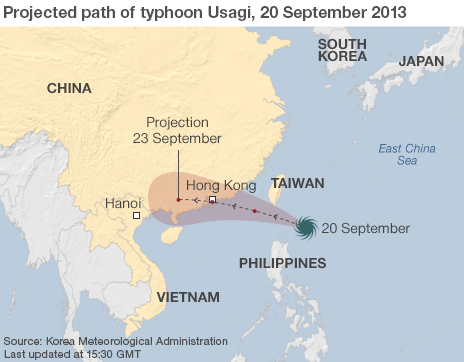
Category 2 Typhoon Usagi Hits China

Typhoon Usagi veers from Hong Kong at last minute, hits southern China. Usagi made landfall near Shanwei, China, about 90 miles east-northeast of Hong Kong, near 6 pm local time (6 am EDT) on Sunday. At landfall, Usagi was a powerful Category 2 typhoon with top sustained winds of 110 mph. Shanwei recorded a sea level pressure of about 941 mb at landfall. As of noon EDT, the top winds recorded at the Hong Hong Airport were sustained at 40 mph, with gusts to 53 mph.

The year's most powerful typhoon slammed into southern China on Sunday evening, forcing hundreds of flight cancellations, shutting down shipping and putting a nuclear power plant on alert after pummelling parts of the Philippines and Taiwan with heavy rains and fierce winds. Forecasters had warned earlier that it posed a "severe threat" to the southern Chinese city of Hong Kong.

Newly formed Tropical Storm Pabuk is a threat to Japan, but likely to have no impact on Taiwan, the Central Weather Bureau said Saturday. Pabuk strengthened from a tropical depression north of Guam on Saturday afternoon.

NewsBytes:

Dangerous storm hits Perth, Australia. About 20,000 homes have been left without power after violent 146km/h winds hit the South West and metropolitan Perth, Australia.

Tornado in Maungatapu, New Zealand has damaged houses and downed trees.

Wildfires

Bush Fires Across Queensland, Australia

Yesterday firefighters were at the scene of 28 fires across Queensland.

At the moment the State's high temperatures, low humidity and strong winds are ideal conditions for bushfires.

Sunday 22 September 2013

Earthquakes

Magnitude 5+ Earthquakes – Global

5.9 Earthquake hits south of the Kermedec Islands.

5.5 Earthquake hits the Near Islands in the Aleutian Islands.

5.4 Earthquake hits the Molucca Sea.

5.3 Earthquake hits Chihuahua, Mexico.

4.9 Earthquake hits Wyoming, USA.

Storms and Floods

Tropical Storms

In the Western Pacific:

Typhoon Usagi is located approximately 267 nm east of Hong Kong. Usagi - the year's most powerful typhoon - slammed into the Philippines' northernmost islands on Saturday Sept. 21, cutting communication and power lines, triggering landslides and inundating rice fields.

Typhoon Usagi weakened in Taiwan - No deaths have been reported from Typhoon Usagi but nine people have been injured by falling tree branches in Taiwan. The Central Weather Bureau has lifted a warning for Typhoon Usagi but says continued heavy rain is possible in the eastern and southern highlands.

Usagi brought heavy rains across the island on Saturday, causing floods in some low-lying areas in the southern regions. Accumulated rainfall in eastern Ilan county exceeded 500 millimetres. 3349 residents were evacuated and 1388 people stayed in 62 shelters. The storm had weakened but boats sailing on the Taiwan Strait and the Bashi Channel were warned remain cautious. The sea warning may be lifted this afternoon. The storm was moving west-northwest toward Hong Kong and southern China.

Usagi is likely to be one of the five strongest typhoons to affect Hong Hong in the past 50 years. If the eye of the storm hits just west of Hong Kong, a large storm surge capable of causing over a billion dollars in damage will inundate portions of the coast along the bay that Hong Kong, Macau, and Shenzhen share. Dangerous Category 3 Typhoon Usagi was charging through the Luzon Strait between Taiwan and the Philippines on its way towards China, where landfall is expected near 2 pm EDT on Sunday (early Monday morning local time ) near Hong Hong.

Rain, floods devastate Uruguay sheep farms

Stormy weather played havoc with Uruguayan agriculture and livestock farms, killing thousands of animals, disrupting electricity supplies and communications. Massive waves hit some outlying areas, prompting an orange alert from rescue teams on standby in the area. There were no immediate reports of any human casualties but officials said they were struggling to maintain contact with affected areas where sheep recently sheared for wool died in driving rain and cold. About 1,000 farmers were evacuated from flooded areas.

Trouble began after a cyclone hit parts of the country Sept. 17. Heavy downpours and flooding followed, and large tracts of farming regions were inundated by water. At least 30,000 sheep died in the first reports of impact on farms. The sudden death of thousands of sheep will result in wool shortfalls.

Some of the worst hit areas were Uruguay's north and northwest, where sustained rain, flooding and a sudden drop in temperatures claimed sheep that were recently sheared. Officials warned farmers against eating carcasses of animals killed in the storms. Uruguay has about 8 million sheep, most of the stock maintained for wool and meat exports and for the country's human population of about 3.4 million.

Environment

Oil Spills - Colorado, USA

More oil spills have been found in a Colorado oil field swamped by floodwaters and regulators caution that more oil releases are likely to be found in coming days. The latest spills include 9000 litres of oil spilled from a group of storage tanks, more than 12,000 litres from an oil tank that floated away and at least two others from damaged storage tanks involving unknown volumes. That brings the known volume of oil released since massive flooding began last week along Colorado's Front Range to at least an estimated 83,000 litres. That's about 525 barrels. Unknown yet is whether any pipelines have leaked.

An aerial survey of the flood area on Thursday revealed up to two dozen overturned oil storage tanks. Releases from those tanks could not be immediately confirmed. Also unknown yet is whether any pipelines have leaked.

Saturday 21 September 2013

Earthquakes

Magnitude 5+ Earthquakes – Global

5.7 Earthquake hits the Flores Sea.

5.2 Earthquake hits the South Sandwich Islands region.

5.1 Earthquake hits southwest of Africa.

5.0 Earthquake hits the Rat islands in the Aleutian islands.

5.0 Earthquake hits the Maug Islands in the northern Mariana Islands.

Disease

Poliovirus in Israel, West Bank and Gaza Strip

WHO considers the risk of further international spread of wild poliovirus type 1 (WPV1) from Israel to be high. The risk assessment reflects evidence of increasing geographic extent of WPV1 circulation in Israel over a prolonged period of time. Recently, WPV1 has also been isolated from sewage samples collected by the Palestinian Authority , both in West Bank and the Gaza Strip. No cases of paralytic polio have been reported by Israel or the Palestinian Authority.

Antibiotic Use Warning: Drug Resistance Growing

The U.S. Centres for Disease Control and Prevention (CDC) called on the health care industry and agriculture to cut back on the use of antibiotics to avoid worsening resistance to the medications. “If we don't act now, our medicine cabinet will be empty and we won't have the antibiotics we need to save lives,” warned CDC director Tom Frieden.

The centre estimates that 23,000 Americans die each year due to bacteria already resistant to even the most potent forms of the medicine.

It warns that patients need to understand that antibiotics are not the solution to every illness, and that half of the prescriptions written for them by doctors are not necessary.

Pressure is also mounting for the FDA to ban feeding antibiotics to livestock simply to fatten them up.

The CDC says such use is not necessary “and the practice should be phased out.”

Some farmers argue that when livestock are crammed into huge feedlots, antibiotics keep them from getting infections from other animals.

Storms and Floods

Tropical Storms

In the Atlantic Ocean

Invest 95L, the disturbance over the western Gulf of Mexico, has been hanging on by a thread and barely still exists. NHC has steadily reduced their forecast probability of development into at least a tropical depression, now down to 20%.

There is widespread rain, some of it heavy, in the south-central U.S., which, long meteorological story short, is the result of a long list of sources/ingredients: Ingrid's spin aloft (which helped Manuel reincarnate), Manuel's mid-level spin and mid-upper level moisture, and low-level Gulf moisture circulating northwestward around what's left of Invest 95L, all of which is now interacting with a cold front and a portion of the jet stream.

In the Western Pacific:

Usagi is as of this hour still a Typhoon and its outer fringes have arrived in Taiwan.

The typhoon is undergoing an eyewall replacement cycle, in which a small inner eyewall (ring of intense wind/rain around the eye) gives way to a larger-diameter outer eyewall. Though that can lead to a bit of a decrease in the velocity of the strongest winds in hurricanes/typhoons, it doesn't necessarily mean a decrease in the overall "intensity" i.e. power and destructive potential of the storm, as the size of the area of very strong winds can expand.

70026650 typhoon usagi 464

As Typhoon Usagi moves through SE Asia, heavy rain and howling winds are lashing the northern Philippines and Taiwan as Typhoon Usagi goes through the Luzon Strait which divides them.

Villages have been evacuated, ferries suspended and flights cancelled.

Meteorologists say the storm is the most powerful this year and will bring a cumulative rainfall of 1,000mm (39in) as it heads towards China.

The authorities there have announced a red alert ahead of the expected arrival of the storm on Monday.

The US Navy's Joint Typhoon Warning Centre said on Friday that Usagi was packing sustained winds of 240 km/h (150 mph), with gusts of up to 296 km/h (185mph), making it the equivalent of a strong category four Atlantic hurricane.

Taiwan is reported to have deployed more than 1,600 soldiers in "high risk" areas prone to flooding and landslides while placing 24,000 others on standby.

NewsBytes:

The death toll from the floods and mudslides in Mexico has risen to 100.

La Pintada 010

Wildlife

Honolulu Molasses Spill

Tens of thousands of fish died in Honolulu Harbour after 1,400 tons of molasses spilled from a leaky pipe as the sugary substance was being moved from storage tanks to a ship. The Hawaii Department of Health said that no endangered species have been identified among the more than 26,000 dead fish, shellfish and other marine life that have been collected.

Officials said the spill was one of the worst man-made disasters to strike Hawaii in recent memory.

“There's nothing you can do to clean up molasses,” said Jeff Hull, a spokesman for Matson Inc., the shipping company responsible for the leak. “It’s sunk to the bottom of the harbor. Unlike oil, which can be cleaned from the surface, molasses sinks.”

Matson said it would pay for the entire cleanup costs without passing the charges onto taxpayers or its clients.

Ew130920c

Friday 20 September 2013

Storms and Floods

Tropical Storms

In the Atlantic Ocean

The remnants of Humberto are located about 895 mi (1435 km) WSW of the Azores. The final advisory has been issued on this system.

Invest 95L in the Southwestern Gulf of Mexico's Bay of Campeche will bring more rain to Mexico and tropical moisture from 95L will likely stream northeastwards along the cold front over much of the U.S. Gulf Coast on Saturday and Sunday, bringing heavy rains of 2 - 4". Will likely become a tropical depression during the next day or two and be named Jerry.

In the Eastern Pacific:

The remnants of Manuel are located about 145 mi (235 km) E of Los Mochis, Mexico and could produce additional rainfall amounts of 1 to 2 inches over parts of the Mexican states of Sinaloa, Durango and Chihuahua. The final advisory has been issued on this system.

138 people dead or missing following Manuel's second landfall this week in storm-weary Mexico. Manuel hit the coast on Monday as a tropical storm with 70 mph winds northwest of Acapulco. Acapulco received 7.41" of rain from Manuel September 12 - 16, and up to a foot of rain fell in the surrounding mountains.

Manuel promised to bring 5 - 10" of rain to the Mexican state of Sinaloa, which is likely to cause additional flash floods and mudslides over the next few days. Manuel is moving very slowly inland, and should weaken significantly as long as the storm's eye stays ashore.

In the Western Pacific:

Super Typhoon Usagi is located approximately 360 km northeast of Manila, Philippines. Its track is towards southern Taiwan.

NewsBytes:

A mudslide in southern Russia has claimed the lives of at least seven people. Heavy rainfall triggered the mudslide in Derbent, a city in the North Caucasus republic of Dagestan. Around 300 houses have been flooded in the region.

Flash flooding has hit Guam with 40 centimetres of rain reported in 24 hours in some areas.

Earthquakes

Magnitude 5+ Earthquakes – Global

5.5 Earthquake hits Myanmar.

5.4 Earthquake hits eastern Honshu, Japan.

5.4 Earthquake hits northern Qinghai, China.

5.0 Earthquake hits Kyushu, Japan.

Environment

Colorado, USA Fracking

Colorado is one of the most densely fracked areas in the United States, and people are now beginning to worry about the stability of those fracking sites and wells, many of which have been completely covered by the floodwater. At least one pipeline has already been confirmed to be broken and leaking, and as the Colorado flooding subsides, it is only expected that more broken infrastructure and leaks will begin to surface.

Although no wells appear to be leaking, there are even more serious potential worries. Well sites often contain tanks of toxic wastewater and supplies of potentially hazardous chemicals used in the drilling or extraction processes, which might be damaged by floodwaters and spring leaks. The sites also contain a "spider web" of myriad pipes connecting the wells to tanks or processing equipment, any of which potentially can fracture. If such failures occur, these substances could be picked up by floodwaters, and then contaminate streams, rivers, reservoirs, and other bodies of surface water.

Groundwater contamination, however, probably isn't a major worry. Although the drilling practice of hydraulic fracturing creates fissures that critics say put groundwater at risk of contamination, almost all of the wells in the affected area appear to be active wells that already have been drilled, and little or no fracking currently is going on.

Potential leaks of chemicals and toxic wastewater from the well sites was a "reasonable concern," but so far, there's no evidence of it occurring. To the contrary, inspectors have found only "minor incidents" at the sites, including a free-floating tank that turned out to be empty, and other tanks that had been knocked askew on their foundations by floodwaters, but which hadn't failed. There also were two broken pipelines - one of which was repaired by an on-site crew, while the other was shut down remotely.

Global Warming

End of the Arctic Thaw: Earth Image of the Week

Arctic sea-ice coverage reached its annual minimum in mid-September, leaving Alaska’s North Slope coast with a wide corridor of open water that stretched far to the north. The image below was captured by NASA’s Aqua satellite on the rare sunny afternoon of Sept. 6, 2013.

While there was a deck of clouds far to the north of the Beaufort Sea coast, the various blue hues of the ice-free waters were clearly visible to the satellite’s MODIS sensors.

Summertime melt and rains over the northern slope of the Brooks Range and the Alaskan tundra, carried northward by dozens of small rivers, have brought vast amounts of sediment into the coastal waters over the past three months.

This is evident by the lighter blue colours that swirl along the shore. Some of the freshest runoff appears earthen brown around the mouths of the rivers and in adjacent areas.

The massive oil facilities at Prudhoe Bay use this time of ice-free waters to restock heavy and bulky supplies by ship that are impractical to be carried by truck on the Dalton Highway, which runs parallel to the Trans-Alaska Pipeline from Fairbanks to Deadhorse.

Many residents of Barrow (seen in the enlarged version) undoubtedly enjoyed what was the last sunny and mild day of summer before the Arctic winter season began to descend on the northernmost community in the United States.

The maximum temperature there on Sept. 6 was 51 degrees Fahrenheit, which was 12 degrees above normal. Temperatures have since plunged to freezing and below.

Ew130920xLARGE

Environment

Global Temperature Extremes

The week's hottest temperature was 115.3 degrees Fahrenheit (46.3 degrees Celsius) at Abu Hamed, Sudan.

The week's coldest temperature was minus 89.1 degrees Fahrenheit (minus 67.3 degrees Celsius) at Russia's Vostok Antarctic research station.

Temperatures were tabulated from the more than 10,000 worldwide synoptic weather stations. The United Nations World Meteorological Organization sets the standards for weather observations, and provides a global telecommunications circuit for data distribution.

Volcanos

Roundup of Global Volcanic Activity:

Klyuchevskoy (Kamchatka): Lava flows remain active on the SW upper flank and are often visible on the beautiful KVERT webcam.

KVERT had earlier this week stated that the lava flows may soon interact with glaciers, potentially producing tall ash plumes from phreatic explosions. The Aviation Colour Code was raised to Orange.

Bagana (Bougainville Island, Papua New Guinea): It seems that the volcano has entered a more active phase, producing several explosions in the past days that sent ash plumes to altitudes of 8-9,000 ft (2.4-2.7 km) altitude.

A recent Terra satellite image shows a degassing plume drifting SW, another indication of the presence of fresh magma at the volcano.

Kilauea (Hawai'i): Aloha potential lava viewers, with an eruption & access update,

There are signs of life on the Peace Day lava tube downhill of Pu`u `O`o, with scouts reporting lava flows at the surface around the 1600 foot elevation within but near the top of the abandoned Royal Gardens subdivision. This flow appears to be moving downhill and access will get closer & easier with coming days, but reportedly is already on private land belonging to one of the Kalapana ohana.

Reventador (Ecuador): Activity remains at moderate to high levels. The volcano produces degassing, ash venting and relatively frequent small (strombolian-type) explosions that generate small ash plumes rising a few 100 m. Incandescence can be seen at night, IGPEN reported.

Thursday 19 September 2013

Earthquakes

Magnitude 5+ Earthquakes - Global

5.5 Earthquake hits the Maug Islands in the Northern Mariana Islands.

5.4 Earthquake hits near the north coast of New Guinea, Papua New Guinea.

Storms and Floods

Tropical Storms

In the Atlantic Ocean:

Tropical storm Humberto is located about 1035 mi (1670 km) WSW of the Azores. There is still time for Humberto to strengthen some as it moves into a more favorable upper-level wind environment, but it is no threat to U.S. land areas.

Invest 95L , an area of disturbed weather over the Yucatan Peninsula, will emerge into the Southwestern Gulf of Mexico's Bay of Campeche by Wednesday night. Will bring more rain to Mexico and tropical moisture from 95L will likely stream northeastwards along the cold front over much of the U.S. Gulf Coast on Saturday and Sunday, bringing heavy rains of 2 - 4".

In the Western Pacific:

Tropical storm Usagi is located approximately 465 nm east-northeast of Manila, Philippines. Its track is towards southern Taiwan.

Typhoon Usagi has intensified to a Category 1 storm with 75 mph winds. Further intensification is likely over the next few days, as Usagi is over very warm waters of 29 - 30°C with high heat content, and is under light wind shear of 5 - 10 knots. The official JTWC forecast brings Usagi to a Category 3 storm before encountering Taiwan, when interaction with land could potentially weaken the storm. The typhoon is expected to pass north of the Philippines Islands on Friday, and will threaten southern Taiwan on Saturday.

Tropical depression Eighteen is located 21 nm north-northwest of Da Nang, Vietnam. The final advisory has already been issued on this system.

In the Eastern Pacific:

Tropical storm Manuel has regenerated and is quickly reaching hurricane strength. It is located about 120 mi (190 km) WNW of Mazatlan, Mexico. The centre of Manuel will approach the west-central coast of Mexico within the Hurricane Watch area Thursday afternoon.

The destructive storm promises to bring even more misery to a Mexican nation already reeling from the combined one-two punch of Manuel on its Pacific coast and Hurricane Ingrid on the Atlantic coast earlier this week. The two storms are now being blamed for the deaths of at least 57 people in Mexico.

NewsBytes:

Ukraine - Two people were killed after heavy rains hit southern Ukraine’s Odessa region over the weekend. The ensuing floods drowned some 4,000 farm animals and poultry, and destroyed or severely damaged more than 450 houses.

A tornado touched down near Lynden Pindling International Airport in Nassau in the Bahamas.

547226 699874366707790 1081614063 n

Environment

How Much Longer Can Earth Support Life?

Earth could continue to host life for at least another 1.75 billion years, as long as nuclear holocaust, an errant asteroid or some other disaster doesn't intervene, a new study calculates.

But even without such dramatic doomsday scenarios, astronomical forces will eventually render the planet uninhabitable. Somewhere between 1.75 billion and 3.25 billion years from now, Earth will travel out of the solar system's habitable zone and into the "hot zone," new research indicates.

These zones are defined by water. In the habitable zone, a planet (whether in this solar system or an alien one) is just the right distance from its star to have liquid water. Closer to the sun, in the "hot zone," the Earth's oceans would evaporate. Of course, conditions for complex life — including humans — would become untenable before the planet entered the hot zone.

Earth apocalypse

Global Warming

Arctic Sea Ice Closes In on Summer Low

The Arctic icepack appears to have reached its summer low this week. The annual summer melt season shrank the polar ice cap down to 5.10 million square kilometres (2.00 million square miles) on Sept. 16, according to the National Snow & Ice Data Centre (NSIDC) in Boulder, Colo. Now, NSIDC scientists are tracking the Arctic icepack's shifting boundaries via satellite to confirm whether the Sept. 16 extent was the minimum, a spokeswoman for the research centre said. The ice can wax and wane before heading into the fall refreeze.

This year saw much more ice cover than 2012, which set an all-time record for the lowest summer ice extent. The Northwest Passage was closed for the first time since 2007. But if Sept. 16 was the summer low, then 2013 was still a sixth place finisher for the lowest amount of summer ice since record-keeping started in the Arctic 30 years ago. And the overall volume of ice — a measure of its thickness — continues to decrease as well.

Climate models predict that climate change will cause large variations in the summer ice from year to year, according to a statement from the NSIDC. This year, cool summer weather in the Arctic helped the ice stick around for the summer, the NSIDC said. Air temperatures were colder than average in the Arctic, which helps retain a thin layer of ice, increasing the overall ice extent.

N stddev timeseries

Wildlife

Bees Reintroduced in Britain

A species of bee reintroduced to the UK after becoming extinct has nested for the first time in a quarter of a century. The short-haired bumblebee started dying out in Britain in the 1980s and officially became extinct in 2000. A reintroduction project saw queen bees brought over from Sweden.

After two releases of queens at the RSPB's Dungeness reserve in Kent, offspring worker bees have been recorded there for the first time. Short-haired bumblebees were once widespread across the south of England but declined as their wildflower rich grasslands disappeared. "This is a milestone for the project and a real victory for conservation. We now have proof that this bumblebee has nested and hatched young and we hope it is on the way to become a self-supporting wild species in the UK. It's been a long journey to get here, from creating the right habitat for them, collecting queens in the Swedish countryside, scanning them for diseases and then eventually releasing them at Dungeness. Seeing worker bees for the first time is a fantastic reward for all that hard work but we still have a long way to go to ensure this population is safe and viable."

A first generation of queens, which were released last year, struggled in the summer's cold, wet conditions. But a second release of queens from Sweden bolstered the colony. The reintroduction project has involved work with farmers to create flower-rich meadows in Dungeness and Romney Marsh which have also boosted the numbers of other threatened bumblebees. Further releases are planned to help build the population at Dungeness.

Disease

Novel Coronavirus - Saudi Arabia - Update

WHO has been informed of an additional 18 new laboratory-confirmed cases including three deaths with Middle East respiratory syndrome coronavirus (MERS-CoV) infection in Saudi Arabia.

Volcanos

Roundup of Global Volcanic Activity:

Batu Tara (Sunda Islands, Indonesia): Explosions that produce ash plumes large enough to be spotted on satellite images occur almost daily now. This could be merely an effect of better visibility due to currently better weather with less cloud cover, or indicate an increase of activity. This morning, an ash plume was seen extending 25 nautical miles to the NE, at an estimated altitude of 7,000 ft (2.1 km).

Dukono (Halmahera): An explosion yesterday produced an ash plume rising to about 10,000 ft (3 km) altitude and drifting 25 nautical miles to the NE. (VAAC Darwin)

Mauna Loa (Big Island, Hawai'i): A small earthquake swarm occurred last week under the volcano. During 5-7 September, HVO detected about 350 small earthquakes up to magnitude 2.4 in a tightly clustered area at about 7 km depth west of the summit caldera. Only about 25 were strong enough to be located (map). The swarm was in the same region where earthquakes began to occur a year or more before Mauna Loa's 1975 and 1984 eruptions. A likely interpretation is that the most recent swarm is a sign that some magma has intruded at the base of the volcano. It is certainly no sign of an impending eruption in the very near future, but suggests that Mauna Loa, which still is the world's largest ACTIVE volcano, on the medium term, continues to prepare itself for its next eruption.

Arenal (Costa Rica): OVSICORI mentioned that rockfalls with rumbling noises have increased at the volcano over the past weeks. This could suggest that the volcano has started to wake up from its 3 years of slumber.

Wednesday 18 September 2013

Earthquakes

Magnitude 5+ Earthquakes - Global

5.1 Earthquake hits eastern Turkey.

5.1 Earthquake hits near the east coast of Honshu, Japan.

5.0 Earthquake hits Eritrea.

5.0 Earthquake hits the Bali Sea.

5.0 Earthquake hits the Kepulauan Darat Baya, Indonesia.

Storms and Floods

Tropical Storms

In the Atlantic Ocean:

Tropical Storm Humberto is located about 1070 mi (1720 km) WSW of the Azores.

Remnants of Ingrid dissipating over the mountains of eastern Mexico, about 50 mi (75 km) W of Ciudad Victoria, Mexico. Heavy rainfall and flooding still possible.

In the Western Pacific:

Tropical storm Usagi is located approximately 552 nm south-southeast of Kadena Air Base, Okinawa, Japan. Usagi is forecast to strike Taiwan as a typhoon at about 16:00 GMT on September 21.

Mexico Floods

State of emergency in more than 20 towns in eastern Tamaulipas state after Tropical Storm Ingrid hit the area. Emergency funds also going to western Guerrero state, where Tropical Storm Manuel caused severe flooding. The two almost simultaneous storms have affected two-thirds of the country. At least 47 people have died in flooding and landslides.

Tropical Storm Manuel made landfall on Sunday near the port of Manzanillo, on Mexico's Pacific coast. It caused devastation in the resort town of Acapulco, where at least 21 people were killed in flash floods and landslides. Four thousand people are still in shelters. Thousands of tourists cannot get home as the airport remains closed.

Acapulco residents tried to get out of flooded areas however they could. 40,000 tourists were stranded in the city as the airport is still closed after a power cut and two main highways leading out of the city remain flooded. Manuel dissipated over south-western Mexico on Monday.

But residents of eastern Mexico were hit by Hurricane Ingrid, which was downgraded to a tropical storm shortly before it made landfall on Monday morning near the town of La Pesca. More than 20,000 people were evacuated in the state of Veracruz. Twelve people died when a landslide near the town of Altotonga buried workers trying to clear a road from debris and passengers waiting in a bus to pass. At least 20 highways and 12 bridges were damaged. In Guerrero, 9,000 people remain in shelters after their homes were flooded. Residents living along the river Panuco have been evacuated as it is feared it could break its banks later on Tuesday.

More than 2,000 tourists have been airlifted by the army from Mexico's resort of Acapulco, following deadly floods caused by Tropical Storm Manuel. But many more tourists and local residents remain stranded in the city and along the west coast after landslides blocked main roads. Manuel was almost immediately followed by Hurricane Ingrid, causing widespread devastation in the east of the country. It was the first time since 1958 that two powerful storms hit Mexico within 24 hours.

There are fears that remote hillside communities may be particularly affected. Mexicans are now hoping for a break in the weather to give them a chance to regroup and allow rescuers to operate more freely. But there seems to be no let up in the rain and powerful winds for the time being.

What’s left of Tropical Storm Ingrid promises to dump five inches of rain or more in the mountains west of Eagle Pass in Mexico. The possibility of rain and flooding along the Rio Grande in Eagle Pass conjured up memories of the record flooding in June. That storm dumped more than 13 inches of rain in a 24-hour span. FEMA denied Eagle Pass federal aid because not enough houses were damaged in the June floods. Officials said more than 500 homes were damaged. FEMA has a minimum requirement of 801 homes – regardless of the size of the entity applying for aid. As of now, the remnants of Ingrid have been damaging to interior Mexico and not along the border.

NewsBytes:

Lightning strikes in Odisha, India have claimed the lives of at least 11 people and injured 15 others. A flash of lightning hit a stone quarry at Kaipadar near Khurda, leaving four labourers dead. Another lightning at Kusumati village near Jatni claimed two lives. At least four people died in lightning at Choudwar and Jagatpur. Similarly a farmer died due to lightning in Sundargarh district. Lightning has claimed nearly 200 lives in Odisha in last eight months.

A small tornado touched down in Boca Raton, Florida, USA. No injuries were reported.

Global Warming

Antarctica Sea Ice Hitting Record Highs

Sea ice surrounding Antarctica hit a record high in August and is on track for another record-breaking month in September. Clocking in at a stunning 7.2 million square miles (18.7 million square kilometres), last month's sea ice extent was 4.5 percent above the 1981 to 2010 average and the largest extent since record-keeping started in 1979, according to data released today from the National Oceanic and Atmospheric Administration in its monthly State of the Climate Report.

The record sea ice doesn't contradict global warming. Because Antarctic sea ice encircles a frozen continent, the factors controlling its growth are complex, and include winds, warming air temperatures and even the ozone hole. Wind plays a greater role the size of the ice pack than air temperature or ocean currents, according to a study published in the Nov. 11, 2012, issue of the journal Nature Geoscience. The fierce circumpolar winds carry frigid air from the continent to the sea, freezing the ocean's surface and pushing the ice around. The August ice surge was likely due to weather patterns that favoured more ice, the Antarctic Sun reported.

Antarctica

Tuesday 17 September 2013

Earthquakes

Magnitude 5+ Earthquakes - Global

5.0 Earthquake hits Greece.

5.0 Earthquake hits Vanuatu.

5.0 Earthquake hits the Caucasus, Russia.

5.0 Earthquake hits the Gansu-Nei Mongol border region, China.

Storms and Floods

Tropical Storms

In the Atlantic Ocean:

Tropical storm Humberto is located about 1210 mi (1945 km) WSW of the Azores. No threat to land.

Tropical Depression Ingrid is located about 75 mi (125 km) W of La Pesca, Mexico. Expected to dissipate today.

The death toll from heavy rains and landslides caused by Tropical Storm Manuel and Hurricane Ingrid has risen to claim at least 21 lives in Mexico. The stormy conditions forced thousands to evacuate.

In the Western Pacific:

Tropical storm Man-Yi is located approximately 169 nm south of Misawa, Japan. The final warning has been issued on this system.

NewsBytes:

Floods in Odessa in the Ukraine have claimed the lives of at least two people and displaced around 600 families. Flood waters severely damaged more than 450 houses.

Some areas of New Mexico, USA received close to 10 inches of rain since a deluge that has caused widespread flooding started Tuesday. Parts of Albuquerque have seen more than 4 inches, marking the wettest September on record for the city.

Nature - Images

Interesting Images:

A rare tube-shaped cloud created a spectacle in northern Virginia yesterday (Sept. 16) as it crept across the sky.

Roll cloud 1

Roll clouds belong to a family of low-forming clouds known as arcus clouds. They are related to the more common, wedge-shaped shelf cloud.

Shelf clouds often form on the leading edges of thunderstorms (or sometimes a cold front) as rain-cooled air ploughs under the warm, moist air that's closer to the ground. This warm, moist air is forced upwards and its water vapor condenses into the scary-looking cloud formation.

Roll clouds are sometimes born out of a thunderstorm's gust front, too, and they are "rolled" into shape by storm winds. But unlike shelf clouds, rolls clouds are not attached to the rest of a storm or any other cloud formation.

Space Events

Another Near Miss Asteroid

A tiny asteroid discovered just last week is set to zip by Earth on Wednesday (Sept. 18), passing between our planet and the moon. It is small enough and distant enough that it poses no threat to people, scientists say.

Astronomers first observed the space rock, named 2013 RZ53, on Friday (Sept. 13), according to data from the Minor Planet Centre, a clearinghouse of information on comets and asteroids based in Cambridge, Mass.

The asteroid measures only 3 to 10 feet (1 to 3 meters) across, and it is expected to pass at a safe distance of more than 148,000 miles (230,800 kilometres) away from Earth when it makes its closest approach on Wednesday at 6:20 p.m. EDT (22:20 GMT). (The moon orbits Earth at an average distance of 239,000 miles, or 384,600 km.)

Volcanos

Roundup of Global Volcanic Activity:

Etna (Sicily, Italy): After a phase of complete quiet since 13 September, weak ash emissions occurred again at the New SE crater during the night 16-17 Sep, accompanied by a slight rise of tremor. This activity ceased again during the early hours of today.

Sinabung (Sumatra, Indonesia): A powerful explosion occurred this morning. An ash plume rose to about 6 km height. The volcano continued with near-constant ash venting following the eruption. There are no reports of victims, but ash fall in the area is damaging crops, and prices for vegetables have jumped up.

Monday 16 September 2013

Earthquakes

Magnitude 5+ Earthquakes - Global

5.7 Earthquake hits the Andreanof Islands in the Aleutian Islands.

5.0 Earthquake hits the Andreanof Islands in the Aleutian Islands.

Storms and Floods

Tropical Storms

In the Atlantic Ocean:

Hurricane Ingrid was located about 110 mi (175 km) ENE of Tampico, Mexico. The centre of Ingrid should be very near the coast of Mexico within the Hurricane Warning area this morning. Dangerous storm surge. Ingrid is expected to produce 10 to 15 inches of rain over a large part of eastern Mexico, with isolated amounts of 25 inches possible.

In the Western Pacific:

Tropical storm Man-yi is located approximately 237 nm southwest of Yokosuka, Japan.

Typhoon Man-yi made landfall in Japan bringing torrential rains this morning to western Japan. The major typhoon made landfall in the country’s central region, prompting the weather agency to warn of “unprecedented heavy rain” and urge people to take safety precautions.

The Japan Meteorological Agency issued a “special warning” in three western Japan prefectures of Fukui, Kyoto and Shiga, in the first such issuance since the warning system was introduced late last month. The special warnings were later lifted in Kyoto and Fukui. Local authorities issued evacuation orders to a total of nearly 400,000 residents in Kyoto, Shiga, Hyogo and Mie prefectures. In Kyoto Prefecture, some 260,000 residents were ordered to evacuate, including about 81,000 in Fukuchiyama.

Precipitation during 48 hours through Monday morning reached about 300 ml in parts of Kyoto city and Otsu city, surpassing a monthly average for the month of September. It topped 500 mm in parts of Mie and Nara prefectures. In eastern Japan, gusts in Saitama and Gunma prefectures broke windows and caused other damage.

In the Eastern Pacific:

Tropical storm Manuel was located about 15 mi (20 km) N of Manzanillo, Mexico. Dangerous storm surge. Manuel is expected to produce 10 to 15 inches of rain over portions of the Mexican states of Guerrero and Michoacan, with isolated maximum amounts of 25 inches possible. Manuel was weakening after landfall near Manzanillo on Sunday afternoon. Manuel is expected to dissipate today.

Hurricane Ingrid and Tropical Storm Manuel triggered rain, landslides and floods as they neared Mexico's east and west coasts Sunday, killing at least 19.

NewsBytes:

Colorado Floods Are Being Called 'Biblical' - Six people now confirmed dead. 500+ still unaccounted for. More than 19 000 homes have been damaged by the floods. Colorado's flooding may be linked to recent droughts, which have hardened the soil of the Colorado River Basin, preventing it from absorbing much of the rainfall. Forest fires may also shoulder some of the blame; a portion of the vegetation normally responsible for trapping rainwater burned to the ground in recent years.

Screen Shot 2013 09 16 at 2 35 08 PM

Volcanos

Roundup of New Global Volcanic Activity:

Batu Tara (Sunda Islands, Indonesia): Activity remains strong with frequent explosions of strombolian to vulcanian type. An eruption this morning produced an ash plume detected on satellite images. VAAC Darwin estimated the elevation at 7,000 ft (2.1 km).

Sinabung (Sumatra, Indonesia): A new and seemingly more or less unexpected eruption occurred over night at Sumatra's Sinabung volcano. The Volcanological Survey of Indonesia (VSI) raised the volcanic alert level to 3 (out of 4). Since its first historical eruption in September 2010, the volcano had been closely monitored, but the alert level had been reduced to 2 in October that year, after activity had subsided again.

Kliuchevskoi (Kamchatka): Lava effusion continues. Since the night 10-11 Sep, the lava has changed path and now feeds a second lava flow a bit to the north from the previous one, making it better visible from the KVERT webcam located north of the volcano.

Popocatépetl (Central Mexico): A moderate explosion occurred yesterday at 07:03 (local time), producing an ash plume that rose about 2 km above the crater. The event was accompanied by small amplitude volcanic tremor, and a volcano-tectonic earthquakes of magnitude 2.6. Other than that, the volcano has been fairly calm, with an average of 1-2 small emissions, mostly vapour and gas, per hour.

Nevado del Ruiz (Colombia): The volcano has had a phase of increased degassing producing an important SO2 plume visible on satellite data. No reports of other unusual activity have become known.

Reventador (Ecuador): Activity, both internal and external, remains high, with occasional ash explosions and possibly lava effusion from the summit vent.

Tungurahua (Ecuador): The volcano observatory reports a change in activity, which could herald a new eruptive phase in the near future. Starting from yesterday at approximately 17:00 (local time), increased steaming and gas emissions were visible, producing a column reaching about 1 km height. Incandescence in the crater area could be detected at night as well. Previously, activity had been consisting of weak steaming producing a column of less than 200 m height.

Sunday 15 September 2013

Earthquakes

Magnitude 5+ Earthquakes - Global

5.8 Earthquake hits the Andreanof Islands in the Aleutian Islands.

5.7 Earthquake hits the Bougainville Islands region, Papua New Guinea.

5.4 Earthquake hits the Komandorskiye Ostrova region, Russia.

5.2 Earthquake hits the Andreanof Islands in the Aleutian Islands.

Storms and Floods

Tropical Storms

In the Atlantic Ocean:

Hurricane Ingrid is located about 175 mi (280 km) E of Tampico, Mexico. Expected to make landfall on Monday. Ingird is expected to produce 10 to 15 inches of rain over a large part of eastern Mexico, with isolated amounts around 25 inches possible. A Hurricane Warning is in effect.

In the Western Pacific:

Tropical storm Man-Yi is located approximately 484 nm southwest of Yokosuka, Japan.

In the Eastern Pacific:

Tropical storm Manuel is located about 40 mi (65 km) SSW of Lazaro Cardenas, Mexico. Could be a hurricane when it makes landfall today. Manuel is expected to produce 10 to 15 inches of rain over portions of the Mexican states of Oaxaca and Guerrero, with isolated maximum amounts of 25 inches possible. A storm surge is expected to produce coastal flooding near and to the east of where the centre of Manuel makes landfall. Near the coast, the surge will be accompanied by large and destructive waves. A Hurricane Warning is in effect.

NewsBytes:

Landslide in Abbottabad in the Hazara region of the Khyber Pakhtunkhwa province of Pakistan has claimed the lives of at least four people.

Colorado, USA - Forecasters predict local downpours and flooding will persist through the weekend. Another round of storms swept into battered Colorado on Saturday as weary residents reeled from days of death and destruction wrought by historic flooding. Evacuations continued at a frantic pace as rescuers encountered swamped roads, inundated homes and the dark forecast of more rain to come.

Global Warming

Global Warming Threatens Sweden's Highest Peak

Sweden's highest peak risks losing its title as rising temperatures have eaten away at the glacier that forms the top of the mountain, a researcher said on Friday.

The southern peak of Kebnekaise mountain, the highest point in Sweden, has dropped by about 1m annually for the past 18 years, according to Gunhild Rosqvist, a geographer at Stockholm University.

"It's a clear trend," said Rosqvist, who also heads a research station in northern Sweden where the measurements are carried out. "There is no doubt that the melting process is caused by the warmer weather."

The first measurements of Kebnekaise's southern glacier top were done in 1902, when it was reported at 2 121m above sea level.

This year, it had dropped to 2 099m, giving it only a 3m lead over the mountain's northern summit, which consists of solid rock.

Based on current trends, the northern summit could overtake the title as the highest peak within the next two or three years, said Rosqvist.

Space Events

Meteor over Georgia, Alabama, USA.

NASA officials say brilliant lights in the sky and loud booms reported in Alabama and Georgia came from a meteor that streaked across the South.

A baseball-size fragment of a comet entered Earth's atmosphere above Alabama at 8:18 p.m. CDT Monday.

NASA officials say the meteor traveled at a speed of 76,000 mph. They say just three seconds after hitting the atmosphere, it disintegrated 25 miles above the central Alabama town of Woodstock, producing a flash of light. Because it penetrated so deep into Earth's atmosphere, eyewitnesses heard sonic booms.