Monday 31 July 2017

Earthquakes

Magnitude 5+ Earthquakes – Global

5.8 Earthquake hits the Kuril Islands.

5.3 Earthquake hits off the east coast of Honshu, Japan.

5.1 Earthquake hits the South Sandwich Islands.

5.0 Earthquake hits western Iran.

5.0 Earthquake hits the Kermedec Islands.

Storms and Floods

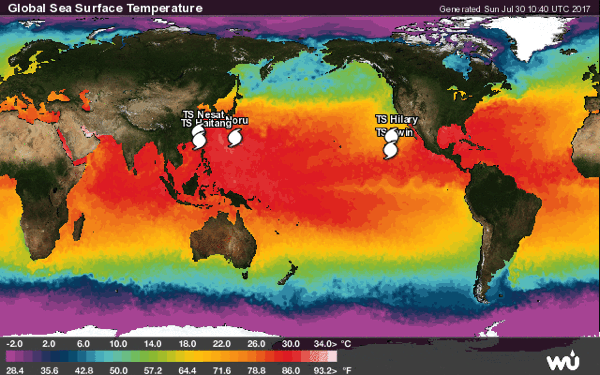
Tropical Storms - Roundup of Tropical Storms:

Gl sst mm

In the Atlantic Ocean: Tropical Depression Six is located about 65 mi...105 km WSW of Tampa Florida and about 65 mi...110 km WNW of Sarasota Florida with maximum sustained winds...35 mph...55 km/h. Present movement...E or 90 degrees at 8 mph...13 km/h.

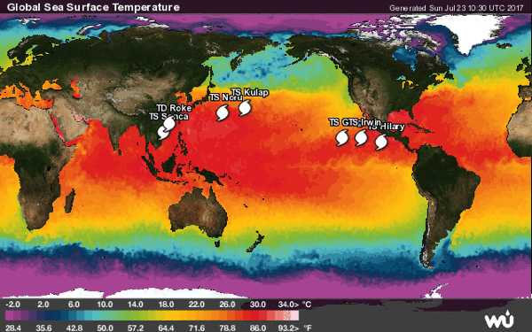
In the Eastern Pacific: Tropical Storm Irwin is located about 1085 mi...1750 km W of the southern tip of Baja California with maximum sustained winds...60 mph...95 km/h. Present movement...NNW or 335 degrees at 13 mph...20 km/h.

Post-Tropical Storm Hilary is located about 1185 mi...1905 km WNW of the southern tip of Baja California with maximum sustained winds...35 mph...55 km/h. Present movement...WNW or 300 degrees at 14 mph...22 km/h.

In the Western Pacific: Super Typhoon 07w (Noru), located approximately 141 nm southwest of Iwo To, is tracking westward at 07 knots.

Tropical storm 11w (Nesat), located approximately 128 nm west-northwest of Taipei, Taiwan, is tracking northwestward at 11 knots.

Tropical depression 12w (Haitang), located approximately 130 nm west-northwest of Taipei, Taiwan, is tracking northwestward at 15 knots.

NewsBytes:

India Floods Update - Severe monsoon flooding has now killed 213 people in western India, an official said Sunday, as rescuers continue to sift through villages devastated by torrential rains. The death toll in Gujarat state jumped from Wednesday's total of 123 as waters recede from low-lying areas, allowing workers to reach remote spots where bodies are starting to appear. Rescue workers have moved close to 130,000 people from low-lying, dangerous areas as helicopters and boats try to reach those still stranded. In Assam at least 77 people have been killed and a state-wide emergency relief operation has been underway since April. Tens of thousands of acres of crops have been destroyed. The flood toll in Odisha rose to seven with the death of three more persons in Jajpur district.

Global Warming

Rare mega-tsunami in Greenland

On the evening of June 17, residents in the Greenland village of Nuugaatsiaq felt a low rumble shake the ground.

Within five minutes, a giant tsunami arrived, caused by a massive landslide in Greenland’s Karrat Fjord. The wave washed away 11 homes, leaving four people in the town of 84 residents presumed dead. But because the tsunami struck in a remote location, researchers didn’t know how exactly it had originated and how big it had been. That’s crucial information, since another landslide is likely to happen in coastal Greenland very soon—and even more enormous waves will be on the way around the world as climate change worsens.

Tsunamis caused by landslides in bays can rise to incredible heights, travel at devastating speeds, and cause massive destruction. The biggest one ever recorded occurred in 1958 in Lituya Bay in Alaska, reaching more than 500 meters in height—almost as tall as the Sears Tower in Chicago or Canton Tower in Guangzhou. A similar, albeit smaller, tsunami is thought to have destroyed Geneva in 563 CE.

Disease

Sri Lanka dengue update

In the month of July, Sri Lankan health authorities have reported more than 27,000 dengue fever cases, almost triple the number of cases reported in July 2016 (10,715) bringing the 2017 year-to-date total to 114,215, including more than 300 deaths.

Sunday 30 July 2017

Earthquakes

Magnitude 5+ Earthquakes – Global

5.2 Earthquake hits Lake Edward, Uganda.

5.1 Earthquake hits Fiji.

5.0 Earthquake hits Colombia.

Storms and Floods

Tropical Storms - Roundup of Tropical Storms:

Gl sst mm

In the Eastern Pacific: Tropical Storm Irwin is located about 1060 mi...1700 km WSW of the southern tip of Baja California with maximum sustained winds...60 mph...95 km/h. Present movement...N or 350 degrees at 9 mph...15 km/h.

Tropical Storm Hilary is located about 940 mi...1510 km W of the southern tip of Baja California with maximum sustained winds...45 mph...75 km/h. Present movement...WNW or 300 degrees at 14 mph...22 km/h.

In the Western Pacific: Typhoon 07w (Noru), located approximately 91 nm south of Iwo To, is tracking south-southwestward at 04 knots.

Tropical storm 11w (Nesat), located approximately 128 nm west-northwest of Taipei, Taiwan, is tracking northwestward at 11 knots.

Tropical storm 12w (Haitang), located approximately 216 nm south-southwest of Taipei, Taiwan, is tracking north-northeastward at 17 knots.

NewsBytes:

China - At least 10 people were killed after a flood hit China's northwestern Shaanxi province. Heavy rains hit Yulin City in northern Shaanxi from Tuesday night and caused floods in a number of areas. Floods in China. ReutersFloods in China. More than 71,300 people were forced to evacuate, the provincial flood control headquarters said. Power supplies and telecommunications were also disrupted.

Taiwan - Taiwan suffered flooding, widespread power outages and winds of over a hundred miles an hour as it was battered by its first typhoon of the year on Saturday. Much of the island came to a standstill, with most train services suspended and as many as 249,230 households without electricity as Typhoon Nesat (Gorio in the Philippines) — packing gust of up to 180 kilometers (111.8 miles) an hour — blasted across the country. The storm made landfall at 1110 GMT in the eastern Yilan county, whipping up massive waves of over 15 meters (49.2 feet).

Disease

Canada cyclospora outbreak - Update

The number of cases in the Cyclospora outbreak in British Columbia and Ontario has nearly doubled since the last report two weeks ago. Since July 14, 47 additional cases were reported. A total of 104 cases have been reported in two provinces: British Columbia (6) and Ontario (98). The source of the outbreak has not been identified.

Texas: Cyclospora

Less than two weeks after issuing a health advisory, the Texas Department of State Health Services (DSHS) is reporting 145 cases of infection with the parasite, Cyclospora.

Long-lasting illnesses caused by the parasite, with symptoms like watery diarrhea, loss of appetite and fatigue, have been seen in various parts of the state and have prompted public health experts to advise health care providers and the public to be aware of the symptoms and pursue testing when needed.

Somalia: Cholera

The Ministry of Health of Somalia has reported 1068 acute watery diarrhea (AWD)/cholera cases and 3 deaths for week 28 (10 – 16 July 2017) with a case-fatality rate of 0.3%.

The cumulative number of cases stands at 58,524, including 812 deaths, in 15 regions across the country. The overall case-fatality rate of 1.4% remains above the emergency threshold of 1%. However, the cholera outbreak which started in January 2017 is slowing down, thanks to timely interventions by WHO, national health authorities and health partners.

Saturday 29 July 2017

Earthquakes

Magnitude 5+ Earthquakes – Global

5.1 Earthquake hits southeast of the Loyalty Islands.

5.0 Earthquake hits offshore northern California.

Storms and Floods

Tropical Storms - Roundup of Tropical Storms:

Gl sst mm

In the Eastern Pacific: Tropical Storm Irwin is located about 1125 mi...1810 km WSW of the southern tip of Baja California with maximum sustained winds...60 mph...95 km/h. Present movement...NW or 305 degrees at 1 mph...2 km/h.

Tropical Storm Hilary is located about 715 mi...1150 km W of the southern tip of Baja California with maximum sustained winds...65 mph...100 km/h. Present movement...NW or 305 degrees at 10 mph...17 km/h.

In the Western Pacific: Typhoon 07w (Noru), located approximately 60 nm south of Chichi Jima, is tracking south-southwestward at 09 knots.

Tropical storm 11w (Nesat), located approximately 342 nm southeast of Taipei, Taiwan, is tracking northwestward at 08 knots.

Tropical storm 12w (Haitang), located approximately 266 nm southeast of Hong Kong, is tracking north-eastward at 05 knots.

NewsBytes:

Thailand - A number of residential areas in the northeastern region were hit by flash floods Friday as a result of a tropical storm blowing from South China Sea. The flood – the worst in 40 years by some accounts – was particularly severe in the city of Sakon Nakhon, where residents found water rushing into their homes in a time span of less than a day. The local airport was also forced to shut down by Friday afternoon.

Maryland, USA - Montgomery County could see some flash flooding Friday and Saturday as heavy rains hit the area, according to the National Weather Service. By Saturday, the area could get up to three or four inches of rain, he said. Similar rainfall is expected throughout the state, but Baltimore and Washington, D.C., could get five or more inches.

Disease

Ohio, USA - Swine Flu

According to the Centers for Disease Control and Prevention (CDC), eleven human infections with novel influenza A viruses were detected in Ohio during the week of July 16.

All 11 persons were infected with influenza A (H3N2) variant (H3N2v) viruses and reported exposure to swine in a fair setting during the week preceding illness onset. Ten of the 11 patients were children less than 18 years of age and one patient was an adult aged 50-64 years. None were hospitalized and all have fully recovered from their illness.

No human-to-human transmission has been identified. Swine influenza A (H3N2) viruses were identified from respiratory samples collected from pigs at the same fair.

Friday 28 July 2017

Earthquakes

Magnitude 5+ Earthquakes – Global

5.8 Earthquake hits the North Atlantic Ocean.

5.7 Earthquake hits Buru, Indonesia.

5.3 Earthquake hits the Izu Islands off japan.

5.2 Earthquake hits the Komandorskiye Ostrova region, Russia.

5.0 Earthquake hits southern Sumatra, Indonesia.

5.0 Earthquake hits the Solomon Islands.

5.0 Earthquake hits Vanuatu.

Over 500 earthquakes in Reykjanes swarm

The swarm of earthquakes that originate in Fagradalsfjall mountain on the Reykjanes peninsula are now on the decrease. A few earthquakes occurred yesterday morning but they're diminishing.

According to the Iceland Met Office, over 500 earthquakes have been measured in the swarm which began Wednesday morning at 7 am. Three earthquakes were clearly felt in Reykjavik, especially the one at 13:55 which measured 4.1.

Geophysicist Páll Einarsson said speaking to today's Morgunblaðið that the earthquakes are at the point where the tectonic plates meet. He said that although earthquakes in Reykjanes are common, the swarm yesterday was one of the biggest that they've measured in a few years.

Storms and Floods

Tropical Storms - Roundup of Tropical Storms:

Gl sst mm

In the Eastern Pacific: Tropical Storm Irwin is located about 1120 mi...1800 km WSW of the southern tip of Baja California with maximum sustained winds...50 mph...85 km/h. Present movement...W or 270 degrees at 2 mph...4 km/h.

Tropical Storm Hilary is located about 590 mi...955 km WSW of the southern tip of Baja California with maximum sustained winds...70 mph...110 km/h. Present movement...WNW or 300 degrees at 8 mph...13 km/h.

In the Western Pacific: Typhoon 07w (Noru), located approximately 163 nm northeast of Chichi Jima, is tracking southwestward at 09 knots.

Tropical storm 11w (Nesat), located approximately 342 nm southeast of Taipei, Taiwan, is tracking northwestward at 08 knots.

Tropical depression 12w (Twelve), located approximately 220 nm south-southeast of Hong Kong, is tracking westward at 08 knots.

NewsBytes:

Ghana - Ghana has been hit by deadly floods in the northern region. Most areas of the regional capital, Tamale got flooded after heavy rains on Tuesday flooded major areas. Local media reported two deaths and the loss of properties.

Philippines - Heavy rains battered parts of the Philippines Thursday, July 27 due to southwest monsoon enhanced by a severe tropical storm. The country’s weather bureau said this year’s seventh cyclone ‘Noru,’ locally known as ‘Gorio,’ has intensified into a severe tropical storm. ‘Gorio’ is not expected to make landfall, but Batanes in northern Luzon is now placed under warning signal number one. Western Luzon has been damped with moderate to occasional heavy rains. The rest of Luzon and parts of the Visayas region have been affected as well. Many roads were impassable due to persisting floods. Floods in some parts of Quezon City are waist-deep. The weather has prompted dozens of cities and provinces to suspend classes in all levels of public and private schools.

Istanbul, Turkey - At least ten people were injured - two of them seriously - when a violent thunderstorm struck Istanbul, bombarding the city with hailstones the size of golf balls and submerging much of the city in knee-deep water. he unforgiving winds, rain and hail appear to have worn away the paint on the Turkish Airline jet's nose, with cracks visible on the pilots' window. he plane was forced to make an emergency landing in the Aegean city of Canakkale, around 170 miles flight from Istanbul which endured the worst of the freak storm.

42C04FF700000578 4737174 image a 10 1501195300387

Wildfires

Wildfires - Portugal

Portugal's Civil Protection Agency says firefighters have brought under control a major 5-day-old wildfire that blackened a wide area of pine and eucalyptus forest.

The blaze at Serta, about 200 kilometers (125 miles) northeast of Lisbon, is believed to have charred more than 25,000 hectares of woodland.

Other fires broke out Thursday, however, amid continuing hot and windy weather. The Weather Institute says more than 70 percent of Portugal is experiencing severe drought conditions. The Civil Protection Agency reports it has deployed more than 1,100 firefighters and 23 water-dropping aircraft to 13 blazes. Ten villages had already been evacuated after fires broke out on Sunday. By about midnight last night the fires had reached Macao, a town with a population of 2,000.

Environment

Sizzling Shanghai, China

Shanghai registered on July 21 its hottest day since records began in 1872 as a stubborn heat wave baked much of China. The new record of 40.9 degrees Celsius (106 F) broke the previous record of 40.8 set in 2013.

Chinese meteorologists say Shanghai is getting hotter, with eight of the 12 highest temperatures over the past century occurring during the past five years.

Shanghai’s weather bureau blamed the heat on a stubborn subtropical high and southwesterly winds that are predicted to last until early August. That’s when the typhoon season typically arrives in eastern China.

Atomic Paradise

Even though it’s still unsafe for people to live on Bikini Atoll, marine life is thriving 60 years after a series of 23 atomic blasts left it saturated with radiation.

Scientists from Stanford University say coconut crabs, coral and other species that have managed to re-emerge on Bikini show barely any genetic differences from those living in uncontaminated parts of the Pacific.

Lead researcher Stephen Palumbi believes that at least the coral have mechanisms to protect their genetic information from radiation.

Global Warming

Climate change drawing squid, anchovies and tuna into UK waters

Squid and anchovies, more commonly eaten by Britons holidaying abroad, are being drawn into UK waters in large numbers by climate change, according to major new report that suggests the nation’s long-lost bluefin tuna is also returning.

However, global warming is harming sea birds, such as puffins, fulmars, terns and razorbills, as the fish they rely on are driven north or deeper as waters warm. The analysis of the impact of climate on the UK’s seas, which draws on the work of 400 scientists, found a steady rise in water temperature.

It also found a clear rising trend in sea level, leading to much more frequent extreme high water events. Improved defences and forecasting have prevented an increase in coastal floods, but the report warns that sea level rise around the UK is likely to accelerate.

Squid were seen in the North Sea only occasionally in the past but have increased “dramatically”, according to the report, with thousands of tonnes now caught each year and mostly exported.

Anchovies have followed the same path northwards. “You now have an anchovy fishery, which is clearly linked to climate change – that is what the science is showing,” said Frost. The anchovies come from the Bay of Biscay, where there is a large Spanish and French fishery.

Bluefin tuna were common around the UK before the second world war, with the giant fish a popular target for “big game” fishermen. The decimation in later decades of the mackerel and herring that tuna eat then saw the giant fish disappear. But shifting mackerel and herring populations and warming waters have seen the tuna return.

Screen Shot 2017 07 28 at 1 11 03 PM

Nature - Images

Interesting Images

A curling tongue of clouds reaches out to touch Portugal on the Iberian Peninsula in a new satellite image.

Screen Shot 2017 07 28 at 12 44 17 PM

Environment

Global Temperature Extremes

The week's hottest temperature was 123.0 degrees Fahrenheit (50.5 degrees Celsius) in Death Valley, California.

The week's coldest temperature was minus 91.0 degrees Fahrenheit (minus 68.3 degrees Celsius) at Vostok, Antarctica.

Temperatures were tabulated from the more than 10,000 worldwide synoptic weather stations. The United Nations World Meteorological Organization sets the standards for weather observations, and provides a global telecommunications circuit for data distribution.

Volcanos

Roundup of Global Volcanic Activity - Ongoing Activity for the week of 19 July - 25 July 2017

Bagana | Bougainville (Papua New Guinea) : Based on analyses of satellite imagery and model data, the Darwin VAAC reported that on 23 July an ash plume from Bagana drifted W at an altitude of 2.1 km (7,000 ft) a.s.l.

Bezymianny | Central Kamchatka (Russia) : KVERT reported that during 14-21 July a thermal anomaly was identified daily over Bezymianny in satellite images. A lava flow continued to move down the W flank of the dome. The Aviation colour Code remained at Orange (the second highest level on a four-colour scale).

Bogoslof | Fox Islands (USA) : AVO reported that during 19-25 July no significant activity at Bogoslof was observed in cloudy or mostly cloudy satellite images, and no activity was detected in seismic, infrasound, or lightning data. The Aviation colour Code remained at Orange and the Volcano Alert Level remained at Watch.

Cleveland | Chuginadak Island (USA) : AVO reported that during 19-23 July elevated surface temperatures from Cleveland were identified in satellite images; no activity was observed in seismic, infrasound, or web-camera data although these data had been intermittent. On 21 July AVO noted that a new small lava dome, about 30 m in diameter and 10 m high, had appeared at the bottom of the summit crater within the previous week. The webcam recorded a weak steam plume rising from the summit crater on 25 July. The Aviation colour Code remained at Orange and the Volcano Alert Level remained at Watch.

Dukono | Halmahera (Indonesia) : Based on analyses of satellite imagery, wind model data, and notices from PVMBG, the Darwin VAAC reported that during 21-25 July ash plumes from Dukono rose to altitudes of 1.5-1.8 km (5,000-6,000 ft) a.s.l. and drifted E and NE.

Karymsky | Eastern Kamchatka (Russia) : KVERT reported that explosions at Karymsky on 18 July generated ash plumes that rose 1.7 km (5,600 ft) a.s.l. Satellite images showed a weak thermal anomaly over the volcano during 18-20 July, and ash plumes drifting 117 km E on 20 July. The Aviation colour Code remained at Orange (the second highest level on a four-colour scale).

Kilauea | Hawaiian Islands (USA) : During 19-25 July HVO reported that the lava lake continued to rise, fall, and spatter in Kilauea’s Overlook crater. Webcams recorded incandescence from long-active sources within Pu'u 'O'o Crater. The 61G lava flow, originating from a vent on Pu'u 'O'o Crater's E flank, continued to enter the ocean at Kamokuna. Several large cracks running parallel to the coastline spanned the width of the delta. Surface lava flows were active above the pali and on the coastal plain about 2 km upslope from the gravel emergency route.

Klyuchevskoy | Central Kamchatka (Russia) : KVERT reported that during 19-20 July a weak thermal anomaly over Klyuchevskoy was identified in satellite images, and ash plumes drifted 300 km SW, SE, E, and NE. The Aviation colour Code remained at Orange (the second highest level on a four-colour scale).

Nishinoshima | Japan : The Japan Coast Guard reported that visual observations of Nishinoshima from an aircraft during the afternoon of 11 July confirmed that the eruption was ongoing. Emissions from the center of the cone were grayish white and tephra was ejected. The lava flow on the W flank continued to enter the ocean. Based on a pilot observation the Tokyo VAAC reported that on 18 July an ash plume rose to 3 km (10,000 ft) a.s.l.

Poas | Costa Rica : OVSICORI-UNA reported that during 19-24 July plumes of magmatic gases, water vapor, and aerosols were emitted from Poás’s vent A (Boca Roja), and plumes of gases, water vapor, and abundant yellow particles of native sulfur rose from vent B (Boca Azufrada). Plumes rose 300-500 m above the vents and drifted W and SW.

Sabancaya | Peru : Observatorio Vulcanológico del Sur del IGP (OVS-IGP) and Observatorio Vulcanológico del INGEMMET (OVI) reported that since the beginning of July there had been a gradual increase in activity at Sabancaya associated with rising magma and increased sulfur dioxide gas emissions. Gas-and-ash plumes rose to moderate heights, between 2.5 and 4.5 km above the crater rim. On 22 July winds shifted S and SE, causing ashfall in Lluta (30 km SW), Huanca (75 km SSE), and in some parts of Arequipa (80 km SSE).

Sheveluch | Central Kamchatka (Russia) : KVERT reported that a thermal anomaly was identified daily during 14-21 July in satellite images over Sheveluch. Based on video and satellite data explosive activity lasting about 8 hours on 24 July generated ash plumes that rose 11.5-12 km (37,700-39,400 ft) a.s.l. and drifted almost 700 km NE. Strong pyroclastic flows were also observed. The Aviation colour Code was raised to Red (the highest level on a four-colour scale). Later that day only steam-and-gas emissions with a small amount of ash were noted; the Aviation colour Code was reduced to Orange.

Sinabung | Indonesia : Based on PVMBG and pilot observations, satellite and webcam images, and wind data, the Darwin VAAC reported that during 19-25 July ash plumes from Sinabung rose 2.7-6.1 km (9,000-20,000 ft) a.s.l. and drifted in multiple directions.

Suwanosejima | Ryukyu Islands (Japan) : Based on JMA notices and satellite-image analyses, the Tokyo VAAC reported that during 18-19 July ash plumes from Suwanosejima rose to altitudes of 1.8-2.1 km (6,000-7,000 ft) a.s.l. and drifted E.

Turrialba | Costa Rica : OVSICORI-UNA reported that during 19-24 July plumes of water vapor, aerosols, and magmatic gases rose as high as 500 m above Turrialba’s crater rim, and on most nights incandescence emanated from Cráter Oeste. The emissions contained ash during 20-22 July. Minor ashfall was reported in Coronado (San José) on 20 July, and in Sabanilla de Montes de Oca (30 km WSW) on 22 July.

Thursday 27 July 2017

Earthquakes

Magnitude 5+ Earthquakes – Global

5.1 Earthquake hits northern Peru.

Storms and Floods

Tropical Storms - Roundup of Tropical Storms:

Gl sst mm

In the Eastern Pacific: Tropical Storm Irwin is located about 1070 mi...1720 km WSW of the southern tip of Baja California with maximum sustained winds...60 mph...95 km/h. Present movement...WSW or 255 degrees at 6 mph...9 km/h.

Hurricane Hilary is located about 515 mi...825 km SW of the southern tip of Baja California with maximum sustained winds...85 mph...140 km/h. Present movement...WNW or 290 degrees at 12 mph...19 km/h.

In the Western Pacific: Typhoon 07w (Noru), located approximately 443 nm north-northwest of Minami Tori Shima, is tracking nwest-orthwestward at 13 knots.

Tropical storm 11w (Nesat), located approximately 422 nm east-northeast of Manila, Philippines, is tracking north-northwestward at 06 knots.

Dangerous Dance

Screen Shot 2017 07 27 at 1 21 05 PM

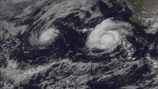
Several storms currently swirl in the Pacific Ocean, with two hurricanes on course for meteorological dance that may end in one dance partner cannibalizing the other.

The bigger storm, Hurricane Hilary, is located several hundred miles south of the Baja California peninsula and has wind speeds of up to 105 mph (165 km/h). Hurricane Irwin is farther west of Hilary and has been weakening, with maximum sustained winds of 80 mph (130 km/h).

Currently, the hurricanes aren't threatening any coastal areas, but they might get locked in a strange dance step known to meteorologists as the Fujiwhara effect. A binary interaction —another name for the Fujiwhara effect —happens when two hurricanes get very close to each other, within about 800 miles (1,290 km), so that their vortices, the spinning centers of the storms, interact.

Two vortices spinning in the same direction will start to orbit around a single center of mass if they get close enough to each other. With two hurricanes that are similar in strength, this center of mass will be the midpoint between the two storms. But if one vortex is stronger, that storm will be closer to the center of the action and could swallow the smaller storm. In this case, Irwin is the smaller storm, and it is expected to pinwheel around the eastern edge of Hilary in the coming days, according to the National Hurricane Center.

NewsBytes:

Screen Shot 2017 07 27 at 1 27 40 PM

Germany - Heavy rains led to flooding Wednesday in some parts of northern Germany, forcing some evacuations and prompting residents to pile sandbags in front of their homes to protect themselves from a swollen river. The center of the town of Goslar, in the mountainous Harz region of northern Germany, west of Berlin, was closed off and a hotel and a home for the elderly were evacuated as its central market square was flooded. Elsewhere, streets were flooded and basements had to be pumped dry of water in the Harz region, and two stretches of railway lines were closed.

Salt Late City, Utah, USA - Flooding from an early morning storm led to some road closures, TRAX delays, flooded basements and power outages Wednesday morning. An inch of rain fell in 40 minutes, according to KSL TV meteorologist Dan Guthrie, causing standing water and flooded areas, particularly in the Salt Lake Valley. Several streets turned into rivers. “The sudden occurrence and intensity of this storm is a 200-year event in Salt Lake City,” said Laura Briefer, Department of Public Utilities director, in a released statement.

Disease

Yemen: Cholera outbreak Update

Through July 25, 2017, the number of suspected cholera cases reported in the Yemen epidemic has surpassed 400,000 since April, 27, 2017. In three months, 402,484 suspected cholera cases and 1,880 deaths (CFR: 0.5%) have been reported in 91.3% (21/23) of Yemen governorates, and 88.9% (296/333) of the districts.

Volcanos

Roundup of Global Volcanic Activity - New Activity for the week of 19 July - 25 July 2017

Piton de la Fournaise | Reunion Island (France) : OVPF reported that seismicity at Piton de la Fournaise increased on 10 July and was followed by a seismic crisis that began around 1250 on 13 July. Events were mainly located below the S edge of Dolomieu Crater, between 500 and 1,000 m a.s.l. Inflation was also detected, concurrent with increased seismicity. An eruption began at 0050 on 14 July in an area 750 m E of the Kala-Pélé peak, 850 m W of Château Fort, and 2.2 km NE of Piton de Bert. During a survey at 0930 scientists observed a fissure about 450 m long with seven lava fountains rising as high as 30 m. The fountain on the downhill end had built up a cone and produced two lava flows. A sulfur dioxide plume drifted E. On 15 July only three fountains were active. The intensity of the eruption fluctuated during 15-17 July, and by 17 July activity was concentrated at one eastern cone. During 18-19 July a few vents within the cone were active, ejecting lava no higher than 20 m above the cone’s rim. By 21 July several lava tubes had formed, and fractures within the tubes produced small lava flows. During an overflight on 22 July scientists noted that the lava flow was over 2.8 km long with a maximum width of 0.6 km; the front of the flow had not advanced in the past seven days. Three main vents were active within the main cone and a fourth was just sporadically active. The eruption continued at least through 25 July.

Planchon-Peteroa | Central Chile-Argentina border : Observatorio Volcanológico de los Andes del Sur (OVDAS) - SERNAGEOMIN reported that the Alert Level for Planchón-Peteroa was raised to Yellow (the middle level on a three-colour scale) on 10 July, noting elevated seismicity (above baseline levels) on 8 July.

Sangay | Ecuador : Based on satellite images and information from the Guayaquil MWO, the Washington VAAC reported that on 20 July an ash plume from Sangay rose to an altitude of 8.2 km (27,000 ft) a.s.l. and drifted W.

Sangeang Api | Indonesia : Based on analyses of satellite imagery, PVMBG observations, and wind data, the Darwin VAAC reported that during 19-20 July ash plumes from Sangeang Api rose to altitudes of 2.4-4.3 km (8,000-14,000 ft) a.s.l. and drifted NW.

Wednesday 26 July 2017

Earthquakes

Magnitude 5+ Earthquakes – Global

5.9 Earthquake hits southeast of the Ryukyu Islands off Japan.

5.8 Earthquake hits eastern Turkey.

5.5 Earthquake hits southwest of Sumatra, Indonesia.

5.3 Earthquake hits Antofagasta, Chile.

5.1 Earthquake hits Minahasa, Sulawesi, Indonesia.

5.0 Earthquake hits west of Macquarie island.

5.0 Earthquake hits Panay in the Philippines.

Storms and Floods

Tropical Storms - Roundup of Tropical Storms:

Gl sst mm

In the Eastern Pacific: Tropical Depression Greg is located about 1065 mi...1715 km E of South Point Hawaii with maximum sustained winds...35 mph...55 km/h. Present movement...NW or 305 degrees at 13 mph...20 km/h.

Hurricane Irwin is located about 905 mi...1455 km WSW of the southern tip of Baja California with maximum sustained winds...80 mph...130 km/h. Present movement...WSW or 255 degrees at 7 mph...11 km/h.

Hurricane Hilary is located about 460 mi...740 km S of the southern tip of Baja California with maximum sustained winds...105 mph...165 km/h. Present movement...WNW or 285 degrees at 12 mph...19 km/h.

In the Western Pacific: Typhoon 07w (Noru), located approximately 327 nm north-northeast of Minami Tori Shima, is tracking northwestward at 13 knots.

Tropical Depression 09w (Kulap), located approximately 475 nm north-northwest of Minami Tori Shima, is tracking west-southwestward at 11 knots.

Tropical storm 11w (Nesat), located approximately 427 nm east-northeast of Manila, Philippines, is tracking northward at 04 knots.

NewsBytes:

Illinois, USA - Severe thunderstorms that brought heavy rain, hail and strong winds to northern Illinois on Monday and Tuesday have exacerbated recent flooding in some areas. The storms caused flood levels to rise, just as they were starting to go down.

Global Warming

Alien species invasions and global warming a 'deadly duo', warn scientists

Invasions by alien species and global warming form a “deadly duo”, scientists have warned, with the march of Argentine ants in the UK a new example. The public are being asked to be on alert for invaders such as the raccoon dog and Asian hornet, as eradication can be near impossible after a species becomes established.

As trade and human travel has become globalised many thousands of species have crossed oceans or mountain ranges and become established in new regions. Recent research shows that ever more animals and plants are finding their way to foreign lands and that invasive species are a “primary threat” to economies, human wellbeing and wildlife.

For example, the Argentine ant is a species that has some indoor populations in London [and elsewhere], but in the last couple of years we have seen those indoor populations spread outdoors. A little bit more climate warming for the UK and we could see the Argentine ant settling in very well.

Screen Shot 2017 07 26 at 3 50 43 PM

Nature - Images

Interesting Images

Wild rabbits surf on sheep to stay alive after a flood strikes New Zealand. Animals riding on others is not unusual in nature in 2015 an image of a weasel riding on a woodpecker went viral.

Wire 1024877 1501056295 716 634x422

Screen Shot 2017 07 26 at 3 40 23 PM

Wildfires

Wildfires - Southern France

Parts of the French Riviera were evacuated late Tuesday and into Wednesday as forest fires burned swathes of land and threatened thousands of people, according to local police.

More than 10,000 residents and tourists were moved after a forest fire started near the coastal commune of Bormes-les-Mimosas, around 40 km (nearly 25 miles) from Toulon, one of the country's southernmost towns.

A combination of strong Mistral winds and a lack of rain have fueled the fires, which took hold in the French Riviera and on the island of Corsica, off the southern French coast.

Tuesday 25 July 2017

Earthquakes

Magnitude 5+ Earthquakes – Global

5.0 Earthquake hits south of Fiji.

5.0 Earthquake hits the Balleny Islands.

5.0 Earthquake hits the southern Mid-Atlantic ridge.

Storms and Floods

Tropical Storms - Roundup of Tropical Storms:

Gl sst mm

In the Eastern Pacific: Tropical Storm Greg is located about 1345 mi...2165 km E of South Point Hawaii and about 1765 mi...2835 km WSW of the southern tip of Baja California with maximum sustained winds...45 mph...75 km/h. Present movement...WNW or 295 degrees at 9 mph...15 km/h.

Hurricane Irwin is located about 770 mi...1235 km SW of the southern tip of Baja California with maximum sustained winds...75 mph...120 km/h. Present movement...WNW or 300 degrees at 5 mph...7 km/h.

Hurricane Hilary is located about 360 mi...575 km S of Cabo Corrientes Mexico and about 565 mi...910 km SSE of the southern tip of Baja California with maximum sustained winds...105 mph...165 km/h. Present movement...WNW or 290 degrees at 10 mph...17 km/h.

In the Western Pacific: Typoon 07w (Noru), located approximately 221 nm east-northeast of Minami Tori Shima, is tracking east-northeastward at 08 knots.

Tropical storm 09w (Kulap), located approximately 512 nm north of Minami Tori Shima, is tracking westward at 15 knots.

Tropical storm 08w (Sonca), located approximately 87 nm northwest of Da Nang, Vietnam, is tracking westward at 12 knots.

NewsBytes:

Jummu and Kashmir, India - A flash flood in Thathri village, Doda district of Jammu and Kashmir has claimed the lives of at least six people. The flash flood damaged the Batote-Kishtwar National Highway, washing away half a dozen houses.

India - More than 25,000 people have been moved to higher ground and at least three are reported to have died in this latest period of floods in Gujarat. Water depths are typically a half to one metre in Banaskantha district, with many rural areas cut off as road, rail and power are all affected. The latest wave of floods in Assam has affected 90,000 people: 160 square km of land is underwater. This is a normal wet season in northeast India which contains the wettest place on earth. In West Bengal, Rajasthan and Gujarat, this recent amount of rain is abnormal. Another metre of rain is possible in western India over the next three days.

Myanmar - Flooding across large parts of Myanmar has displaced more than 100,000 people, causing two deaths, while dramatic riverbank erosion has washed away a Buddhist pagoda. Water levels have risen steadily since unrelenting monsoon rain began to lash the heart of the Southeast Asian country in early July, driving some people to higher land or seek shelter in Buddhist monasteries.

Global Warming

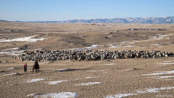
How Mongolia's nomads are adapting to climate change

Harsh winters and dry summers are threatening the livelihoods of Mongolia's nomadic herders. Some are banding together to safeguard their herds - and communities - from the extreme conditions.

For centuries, nomadic families have driven their livestock across Mongolia's steppe, preserving a way of life that goes back generations. But changes in this vast, desolate landscape have forced them to adapt. Winters have become harsher, and extreme weather events more frequent.

Global warming is affecting Mongolia faster than other parts of the world. "Over the last 70 years, the average air temperature has risen by 2.1 degrees Celsius [3.8 degrees Fahrenheit] - one of the highest increases recorded on Earth

Mongolia is one of the last pastoral countries left on Earth. Its economy is dependent on the production of livestock, and around 80 percent of its territory is covered in grasslands. Living at the edge of the habitable world, pastoral nomadic people are highly vulnerable to changes. In response, some herders are forming communities and pooling their resources, in hopes that this will allow their traditional nomadic lifestyles to survive.

Around 28 percent of the Mongolian population lives at or below the poverty line, and many people survive on a subsistence basis. Because of this, and the fragile nature of pastures, extreme weather events are often disastrous in Mongolia. Experts are warning that pastures are at further risk due to overgrazing and climate change. A few centimeters more snow than average locks the forage under a thick frozen layer, and causes high mortality among the livestock.

Due to dzud, (a summer drought followed by a severe winter, generally causing serious loss of livestock) the winter of 1999 to 2000 resulted in the country losing 30 percent of its herds nationwide. As reported by Ulambayar in the scientific journal "World Development," 2 million head of livestock, or 20 percent of the national herd, were lost in the dzud of 2009. And dzud events are projected to increase due to climate change.

Many nomads are abandoning their traditional lifestyle and migrating to the cities. The capital of Mongolia, Ulaanbaatar, is already reeling under the impacts of rapid urbanization, which include off-the-charts air pollution.

39308091 401

Wildfires

Wildfires - Southern France and Corsica

Hundreds of firefighters were battling blazes across southern France on Monday, with one inferno spreading across 900 hectares of forest and threatening homes on the island of Corsica, emergency services said.

Residents were evacuated from homes at the edge of the town of Biguglia, on the island's northeastern coast.

Another fire on the south of the island, which destroyed 110 hectares around the town of Aleria, was brought under control on Monday.

Elsewhere in France, a fire raged in the forests around Luberon in the Vaucluse region, covering 650 hectares. Several homes in the village of Mirabeau had to be evacuated, according to officials.

In the nearby Var region, another fire burned over 200 hectares at Gigaro, close to the Mediterranean resort of Saint-Tropez.

Disease

Vietnam: High hepatitis numbers, Dengue in the Mekong Delta

Vietnam’s health ministry recently reported the viral hepatitis burden in the country of less than 100 million people. According to Xinhua report Monday, the southeast Asian nation currently has 7.8 million of hepatitis B patients and 991,000 hepatitis C cases.

Among the hepatitis B patients, over 51,000 suffer from cirrhosis and over 14,000 others from liver cancer; and among the hepatitis C patients, more than 13,000 suffer from cirrhosis, and nearly 6,000 from liver cancer.

Vietnam has reported nearly 60,000 dengue fever cases year-to-date and according to local media, dengue cases are up in the Mekong Delta.

Dengue fever has increased sharply this year among children aged between 10-15 in the Mekong Delta, especially in Can Tho city. Since the beginning of this year, dengue-related deaths have been reported in Dong Thap, Tien Giang and Tra Vinh provinces.

Romania measles update:

Between 1 January 2016 and 21 July 2017, the Romania National Center for Communicable Disease Control and Control has reported 8,246 measles cases and 32 deaths. Last week, the Health Ministry and the Interior Ministry started a vaccination campaign against measles. There are about 180,000 unvaccinated kids in Romania, according to the Health Ministry.

Swine Flu in Myanmar

A six-year-old boy died and 13 more people were infected in a new outbreak of H1N1 influenza in Myanmar, health authorities said Monday. News about the rise in H1N1 infection spread quickly in Yangon, with some people wearing masks on their faces.

Monday 24 July 2017

Earthquakes

Magnitude 5+ Earthquakes – Global

5.6 Earthquake hits off the east coast of Honshu, Japan.

5.0 Earthquake hits Tonga. 

5.0 Earthquake hits the Kermedec Islands. 

5.0 Earthquake hits the Dodecanese Islands-Turkey border region.

5.0 Earthquake hits southeastern Iran. 

Storms and Floods

Tropical Storms - Roundup of Tropical Storms:

Gl sst mm

In the Eastern Pacific: Tropical Storm Greg is located about 1565 mi...2515 km WSW of the southern tip of Baja California with maximum sustained winds...45 mph...75 km/h. Present movement...WNW or 285 degrees at 9 mph...15 km/h.

Tropical Storm Irwin is located about 745 mi...1195 km SW of the southern tip of Baja California with maximum sustained winds...50 mph...85 km/h. Present movement...W or 270 degrees at 5 mph...7 km/h.

Hurricane Hilary is located about 345 mi...560 km S of Manzanillo Mexico with maximum sustained winds...75 mph...120 km/h. Present movement...WNW or 300 degrees at 8 mph...13 km/h.

In the Western Pacific: Typoon 07w (Noru), located approximately 162 nm north-northwest of Minami Tori Shima, is tracking east-southeastward at 09 knots.

Tropical storm 09w (Kulap), located approximately 664 nm northwest of Minami Tori Shima, is tracking west-northwestward at 14 knots.

Tropical storm 08w (Sonca), located approximately 161 nm east-northeast of Da Nang, Vietnam, is tracking westward at 05 knots.

NewsBytes:

Kentucky, USA - Cars and a home were swept away in floodwaters after a bout of heavy rains pummeled parts of Northern Kentucky early Sunday. The flood waters were so powerful that they sent cars smashing into one another. A mobile home was also swept away by the floodwaters. 5 inches of rain were recorded in the Maysville area.

Nature - Images.txt

Interesting Images

Sleeping dogs lie, but sleeping whales … "stand" on their tails?

Screen Shot 2017 07 24 at 2 20 45 PM

Global Warming

Climate change challenges sinking city of Venice

The Italian city of Venice is prone to frequent flooding because it has sunk five inches over the last century, but it is also grappling with a new challenge: sea-level rise, caused by climate change, which increases the severity.

“Acqua Alta,” meaning high water, has always been a fact of life here. Several times a year, high tides and storm surges flood the city, especially the famous Piazza San Marco. The worst flood occurred in November 1966, when the Venice lagoon rose more than six feet above sea level.

Acqua Alta events are usually less than boot high, last just a few hours, and the city cleans up and goes back to normal. But floods also eat away at the soft, permeable bricks that sit above the foundations of the buildings. Over time, Venetians have raised their doorways and in some cases abandoned their ground floors. But the flooding is getting worse as the water level in the Adriatic Sea and Venice Lagoon rises due to climate change. The sea level alone has risen five and half inches since 1900, according to city officials.

The Italian government does have a plan to protect Venice. It’s called the MOSE project. Conceived in the 1970s, it’s a series of 78 underwater gates secured to the floor of the Venice lagoon. During especially high tides, they will be pumped with air and rise to the surface to block rising water from reaching the city. Four giant barriers across three inlets are scheduled to be operational by 2019.

Screen Shot 2017 07 24 at 2 08 07 PM

Wildlife

New Species Of Sunfish

A new species of sunfish has been discovered for the first time in 130 years after washing up on a New Zealand beach. The two-tonne creature has been named Hoodwinker sunfish (Mola tecta) because of its elusiveness.

Iconic ocean sunfishes are the heaviest and most distinctive of all bony fishes, with some species weighing in excess of two tonnes and growing to three metres in length. The newly discovered species, named the Hoodwinker Sunfish, is thought to approach a similar size, researchers said. Marianne Nyegaard from Murdoch University in Australia uncovered the new species while researching the population genetics of ocean sunfish in the Indo-pacific region.

Fish 630 630

Sunday 23 July 2017

Earthquakes

Magnitude 5+ Earthquakes – Global

5.4 Earthquake hits Minahasa, Sulawesi, Indonesia.

5.1 Earthquake hits the Near Islands in the Aleutian Islands.

5.1 Earthquake hits near the east coast of Honshu, Japan.

5.0 Earthquake hits near the east coast of Honshu, Japan.

5.0 Earthquake hits the Izu Islands off Japan.

Aftershocks hit Greece

Two strong aftershocks have struck the Greek island of Kos within minutes of each other, sending startled residents and tourists scurrying away from homes and restaurants. A tremor measuring a preliminary 4.4 magnitude struck at 8.09pm local time (6.09on BST), sending restaurant customers scurrying toward the middle of the town's main square, as far away as possible from buildings. Sixteen minutes later, a second 4.6-magnitude tremor struck, the Athens Geodynamics Institute reported. The first tremor had its epicentre only 13 miles northeast of Kos at a depth of 6 miles.

Storms and Floods

Tropical Storms - Roundup of Tropical Storms:

Gl sst mm

In the Central Pacific: Post Tropical Cyclone Fernanda is dissipating - the final warning has been issued for this system.

In the Eastern Pacific: Tropical Storm Greg is located about 1290 mi...2080 km WSW of the southern tip of Baja California with maximum sustained winds...50 mph...85 km/h. Present movement...W or 270 degrees at 14 mph...22 km/h.

Tropical Storm Irwin is located about 665 mi...1070 km SSW of the southern tip of Baja California with maximum sustained winds...40 mph...65 km/h. Present movement...WNW or 285 degrees at 9 mph...15 km/h.

Tropical Storm Hilary is located about 485 mi...780 km SSE of Manzanillo Mexico and about 325 mi...520 km SSW of Acapulco Mexico with maximum sustained winds...40 mph...65 km/h. Present movement...WNW or 300 degrees at 15 mph...24 km/h.

In the Western Pacific: Tropical storm 10w (Roke), located approximately 33 nm east of Hong Kong, is tracking west-northwestward at 12 knots.

Tropical depression 07w (Noru), located approximately 268 nm north-west of Minami Tori Shima, is tracking westward at 05 knots.

Tropical storm 09w (Kulap), located approximately 696 nm north of Wake Island, is tracking west-northwestward at 09 knots.

Tropical storm 08w (Sonca), located approximately 197 nm east-northeast of Da Nang, Vietnam, is tracking westward at 03 knots.

NewsBytes:

New Zealand - A ferocious storm has buffeted the lower South Island of New Zealand overnight (Friday-Saturday), with three states of emergency declared in Christchurch, Timaru and Otago and the city of Dunedin accessible only by air. The southern city of 120,000 people was cut off by road after major landslips blocked access. Small coastal communities on the Otago Penninsula are also cut off. Livestock in Canterbury and Otago were urgently being moved to higher ground with numerous rivers rising to near historic levels and threatening to burst their banks. It is the second largest flood of the Taieri River in Otago on record.

Iowa, USA - Heavy rains Friday night and Saturday deluged the community of Sumner, and basement flooding and sandbagging were taking place in several Northeast Iowa communities. As much as 10 inches of rain fell near Fredericksburg during the stretch, according to one calculation. Fairbank and other area communities also were hard hit, many receiving 5 or more inches of rain Friday night and Saturday.

Disease

Hawaii mumps outbreak

Hawaii state health officials reported an additional 18 confirmed mumps cases, bringing the total to 172 in 2017 to date. Twelve of the cases are from Oahu, four are from Kauai and two are from Hawaii Island. Nine of the new cases of individuals are adults.

Saturday 22 July 2017

Earthquakes

Magnitude 5+ Earthquakes – Global

5.3 Earthquake hits Tarapaca, Chile.

5,000-Year-Long Earthquake-Tsunami Record

The discovery of sediment layers in a seaside cave represents the longest record of tsunamis in the Indian Ocean, and the clearest record of tsunamis anywhere in the world.

When the December 26, 2004 Indian Ocean earthquake occurred off the west coast of Sumatra, Indonesia, the 9.1 magnitude event — the third-largest tremor ever recorded on a seismograph — was so strong that it caused the entire planet to vibrate by as much as 0.4 inches. The quake triggered a series of devastating tsunamis that killed up to 280,000 people in fourteen countries, inundating some coastal communities with 100-foot-tall waves. The tsunamis are now regarded as being among the deadliest natural disasters in all of recorded history.

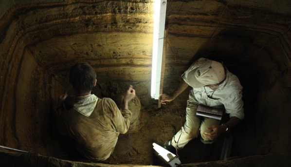
Motivated to better understand quake and tsunami dynamics, scientists Charles Rubin, Benjamin Horton, and their colleagues have been studying the seismic history of the region. Archaeologist Patrick Daly at the Earth Observatory of Singapore (EOS) suggested that they excavate a sea cave about 22 miles south of Banda Aceh, Sumatra.

Analysis of the find, published in the journal Nature Communications, provides a 5,000-year-long sedimentary snapshot of tsunamis in the region. The record shows that eleven tsunamis were generated between 7,900 and 2,900 years ago by earthquakes along the Sunda Megathrust, a 3,300-mile-long fault running from Myanmar to Sumatra along the floor of the Indian Ocean.

The investigation additionally determined that there were two tsunami-free millennia during the 5,000 years, and one century in which four tsunamis struck the coast. The scientists could see that smaller tsunamis tend to occur relatively close together, followed by long dormant periods. These, in turn, tend to be followed by very strong quakes and tsunamis, such as the one that struck in 2004.

According to the researchers, the 5,000-year record of tsunamis represents the first such discovery in a sea cave, the first record of tsunamis over this long of a period in the Indian Ocean, and the clearest record of tsunamis from anywhere in the world.

Sk 2017 04 article text width desktop

The stratigraphy of the sea cave in Sumatra excavated by scientists from the Earth Observatory of Singapore, Rutgers, and other institutions shows lighter bands of sand deposited by tsunamis over a period of 5,000 years and darker bands of organic material, largely consisting of bat guano.

Sk 2017 04 article main desktop

Storms and Floods

Tropical Storms - Roundup of Tropical Storms:

In the Central Pacific: Tropical Storm Fernanda is located about 635 mi...1020 km E of Hilo Hawaii and about 825 mi...1330 km E of Honolulu Hawaii with maximum sustained winds...40 mph...65 km/h. Present movement...WNW or 285 degrees at 8 mph...13 km/h.

In the Eastern Pacific: Tropical Storm Greg is located about 1010 mi...1630 km WSW of the southern tip of Baja California with maximum sustained winds...50 mph...85 km/h. Present movement...W or 275 degrees at 13 mph...20 km/h.

Tropical Depression Nine-E is located about 420 mi...680 km S of Puerto Angel Mexico and about 550 mi...885 km SSE of Acapulco Mexico with maximum sustained winds...35 mph...55 km/h. Present movement...WNW or 285 degrees at 13 mph...20 km/h.

In the Western Pacific: Tropical storm 10w (Roke), located approximately 252 nm east-southeast of Hong Kong, is tracking west-northwestward at 20 knots.

Tropical depression 07w (Noru), located approximately 245 nm north of Minami Tori Shima, is tracking westward at 05 knots.

Tropical storm 09w (Kulap), located approximately 675 nm north-northeast of Wake Island, is tracking westward at 18 knots.

Tropical depression 08w (Eight), located approximately 238 nm east-northeast of Da Nang, Vietnam, is tracking westward at 06 knots.

Gl sst mm

Nature - Images

Interesting Images

Mars Moon - Phobos

Over the course of 22 minutes, Hubble took 13 separate exposures, allowing astronomers to create a time-lapse image showing the tiny moon Phobos during its orbital trek (white dots) around Mars. The grooves on Mars’s moon Phobos could have been produced by tidal forces—the mutual gravitational pull of the planet and the moon.

7 21 17 mars phobos

7 21 17 mars phobos 2

Wildfires

Wildfires - Montana, USA

A series of wildfires burning in Eastern Montana blew up on Thursday and now have torched approximately 48,000 acres — or 75 square miles.

The Bridge Coulee Fire was discovered Wednesday afternoon 16 miles north of Mosby and grew from 2,500 acres Thursday afternoon to over 32,000 acres by late evening.

There are three other fires in Garfield County that are being combined with the Bridge Coulee into the Lodgepole Complex which are estimated to cover nearly 48,000 acres.

The Baker fire, 20 miles north of Sand Springs, has burned 10,000 acres while the South Breaks fire, which is 27 miles northeast of Mosby has burned over 5,000 acres. The third blaze is the Square Butte fire which has burned over 800 acres 19 miles north of Sand Springs.

Disease

Dengue fever – Sri Lanka

Sri Lanka’s dengue epidemic has gone over the 100,000 cases mark with the health ministry putting the tally at 101,698 as of today. This is more than 4-times higher than the average number of cases for the same period between 2010 and 2016.

Dengue Fever - Vietnam

Vietnam has seen in excess of 50,000 dengue fever cases in 2017 to date, including 15 deaths and the capital city of Hanoi has been struck hard in recent weeks by the mosquito borne viral disease, according the Strait Times. The report notes that in just the past week, 1,100 cases have been reported.

Kenya cholera update

In a follow-up on the cholera situation in Kenya, the World Health Organization (WHO) reports a total of 1216 suspected cases including 14 deaths (case fatality rate: 1.2%) have been reported since 1 January 2017.

The cholera outbreak has appeared in Kenya in two waves. The first cholera outbreak reported in 2017 was in Tana River County. The outbreak started on 10 October 2016 and was controlled by April 2017.

A second wave of cholera outbreaks started in Garissa County on 2 April 2017 and was reported later in nine other counties including Nairobi, Murang’a, Vihiga, Mombasa, Turkana, Kericho, Nakuru, Kiambu, and Narok. The outbreak is being reported in the general population and in refugee camps.

Nigeria Cholera Update

Seventeen persons have been confirmed dead in 1,617 reported suspected cases as a cholera outbreak continues to ravage Kwara State in North-central Nigeria.

Friday 21 July 2017

Earthquakes

Magnitude 5+ Earthquakes – Global

6.7 Earthquake hits the Dodecanese Islands - Turkish border region.

At least two tourists have been killed and around 200 others injured after a powerful earthquake shook the Greek Islands and Turkish coast, triggering a small tsunami.

The 6.7-magnitude quake struck in the Aegean Sea on Thursday night south of the Turkish city of Bodrum and east of the small Greek island of Kos - both areas popular with British holidaymakers.

The earthquake triggered a small tsunami that caused flooding in Bodrum and parts of Kos, which took the brunt of the impact with significant damage to buildings.

Tens of thousands of tourists spent the night outdoors on Kos, many sleeping on sunbeds along beaches and in squares.

TELEMMGLPICT000135329390 1 large trans NvBQzQNjv4BqEDjTm7JpzhSGR1 8ApEWQA1vLvhkMtVb21dMmpQBfEs

5.7 Earthquake hits the Pacific-Antarctic ridge.

5.5 Earthquakehits Vanuatu.

5.2 Earthquake hits the Komandorskiye Ostrova region, Russia.

5.2 Earthquake hits the Mariana Islands.

5.1 Earthquake hits the Dodecanese Islands - Turkish border region.

5.0 Earthquake hits off the west coast of northern Sumatra, Indonesia.

5.0 Earthquake hits New Guinea, Papua New Guinea.

Yellowstone Earthquake Swarm Continues

Researchers have now recorded more than 1,200 earthquakes at Yellowstone National Park, part of an ongoing earthquake swarm now in its sixth week.

Storms and Floods

Tropical Storms - Roundup of Tropical Storms:

Gl sst mm

In the Central Pacific: Tropical Storm Fernanda is located about 825 mi...1330 km E of Hilo Hawaii and about 1020 mi...1640 km E of Honolulu Hawaii with maximum sustained winds...50 mph...85 km/h. Present movement...W or 280 degrees at 12 mph...19 km/h.

In the Eastern Pacific: Tropical Storm Greg is located about 800 mi...1285 km SW of the southern tip of Baja California with maximum sustained winds...50 mph...85 km/h. Present movement...W or 280 degrees at 10 mph...17 km/h.

Post Tropical Depression Eight-E is dissipating. The final warning has been issued for this system.

In the Western Pacific: Tropical depression 07w (Noru), located approximately 257 nm north-northeast of Minami Tori Shima, is tracking westward at 10 knots.

Tropical storm 09w (Kulap), located approximately 723 nm northeast of Wake Island, is tracking northward at 10 knots.

Tropical depression 08w (Eight), located approximately 271 nm south of Hong Kong, is tracking west-northwestward at 11 knots.

NewsBytes:

Lancashire, England - Flash floods have hit several homes and businesses in parts of Lancashire. Torrential downpours affected properties in Blackpool, Lancaster and Carnforth on Wednesday night, leaving some homes swamped in up to six inches of water. Firefighters attended several properties to pump out water or isolate electrics. There were no reports of any injuries.

Environment

Global Temperature Extremes

The week's hottest temperature was 124.0 degrees Fahrenheit (51.1 degrees Celsius) in Death Valley, California.

The week's coldest temperature was minus 100.0 degrees Fahrenheit (minus 73.3 degrees Celsius) at Vostok, Antarctica.

Temperatures were tabulated from the more than 10,000 worldwide synoptic weather stations. The United Nations World Meteorological Organization sets the standards for weather observations, and provides a global telecommunications circuit for data distribution.

Wildlife

Ocean Sanctuary

About 735,000 square miles of the Pacific Ocean have been declared one of the world’s largest marine sanctuaries as the Cook Islands moves to help protect its territorial waters for future generations.

The island nation has a population of only about 10,000, living on 15 islands. But its position between New Zealand and Hawaii with no nearby neighbors means it controls a huge maritime territory.

The move to establish the marine reserve, known as Marae Moana, was approved by the country’s traditional leaders.

Wildfires

Wildfires - California

Wildfires across California have now forced the evacuation of 5,000 people as the blaze threatens 1,500 homes across the state's historic Gold Rush region.

A blaze burning in foothills west of Yosemite National Park destroyed dozens of structures and forced thousands to flee Gold Rush-era towns but fire crews have been able to stop it from reaching a threatened community on the foothills of the Sierra Nevada.

The fire was threatening about 1,500 homes and other buildings, after already destroying 29 structures.

Volcanos

Roundup of Global Volcanic Activity - Ongoing Activity for the week of 12 July - 18 July 2017

Bagana | Bougainville (Papua New Guinea) : Based on analyses of satellite imagery and model data, the Darwin VAAC reported that on 16 July an ash plume from Bagana drifted W at an altitude of 2.1 km (7,000 ft) a.s.l.

Bezymianny | Central Kamchatka (Russia) : KVERT reported that a thermal anomaly was identified over Bezymianny daily in satellite images. A lava flow continued to flow down the W flank of the dome. The Aviation colour Code remained at Orange (the second highest level on a four-colour scale).

Cleveland | Chuginadak Island (USA) : AVO reported that during 12-18 July no significant activity at Cleveland was observed in cloudy or mostly cloudy satellite and web camera images; some minor steaming was noted. Moderately elevated surface temperatures were identified in satellite images on 14 July. Aviation colour Code remained at Orange and the Volcano Alert Level remained at Watch.

Copahue | Central Chile-Argentina border : Based on webcam and satellite images the Buenos Aires VAAC reported that during 16-17 July steam-and-ash plumes rose from Copahue to altitudes of 3-3.4 km (10,000-11,000 ft) a.s.l. and drifted N and NW.

Dukono | Halmahera (Indonesia) : Based on analyses of satellite imagery, wind model data, and notices from PVMBG, the Darwin VAAC reported that during 12-15 July ash plumes from Dukono rose to an altitude of 2.1 km (7,000 ft) a.s.l. and drifted W, NW, and S. Ash plumes on 17 July rose 1.5 km (5,000 ft) a.s.l. and drifted E.

Ebeko | Paramushir Island (Russia) : Based on observations by residents of Severo-Kurilsk (Paramushir Island), about 7 km E of Ebeko, explosions during 7-8 July generated ash plumes that rose as high as 1.5 km (4,900 ft) a.s.l. The Aviation colour Code remained at Orange (the second highest level on a four-colour scale).

Karymsky | Eastern Kamchatka (Russia) : KVERT reported that a weak thermal anomaly over Karymsky was identified in satellite images during 7 and 11-12 July. Ash plumes drifted 170 km SW and SE on 10 and 11 July, respectively. The Aviation colour Code remained at Orange (the second highest level on a four-colour scale).

Kilauea | Hawaiian Islands (USA) : During 12-18 July HVO reported that the lava lake continued to rise, fall, and spatter in Kilauea’s Overlook crater. Webcams recorded incandescence from long-active sources within Pu'u 'O'o Crater, from a vent high on the NE flank of the cone, and from a small lava pond (which had many small spattering sites along the margin) in a pit on the W side of the crater. The 61G lava flow, originating from a vent on Pu'u 'O'o Crater's E flank, continued to enter the ocean at Kamokuna. Several large cracks running parallel to the coastline spanned the width of the delta; several small collapses at the leading edge of the delta were noted on 11 July. Surface lava flows were active above and on the pali, and on the coastal plain within 1 km of the base of the pali.

Klyuchevskoy | Central Kamchatka (Russia) : KVERT reported that during 8 and 12-13 July explosions at Klyuchevskoy generated ash plumes that rose as high as 5 km (16,400 ft) a.s.l. and drifted about 50 km SE. A weak thermal anomaly was identified in satellite images during 10-12 July. The Aviation colour Code remained at Orange (the second highest level on a four-colour scale).

Poas | Costa Rica : OVSICORI-UNA reported that during 12-17July gas plumes that rose as high as 1 km above Poás’s vents A (Boca Roja) and B (Boca Azufrada) drifted SW and NW.

Sabancaya | Peru : Observatorio Vulcanológico del Sur del IGP (OVS-IGP) and Observatorio Vulcanológico del INGEMMET (OVI) reported that explosive activity at Sabancaya increased compared to the previous week; there was an average of 19 explosions recorded per day during 10-16 July. Gas-and-ash plumes rose 3.5 km above the crater rim and drifted more than 40 km NW and E. Sulfur dioxide flux was as high as 2,959 tons per day, recorded on 16 July. The MIROVA system detected six thermal anomalies. An explosion at 0931 on 19 July generated an ash plume that rose 4 km above the crater rim and drifted N.

Sheveluch | Central Kamchatka (Russia) : KVERT reported that a thermal anomaly was identified daily in satellite images over Sheveluch during 7-11 July; cloud cover prevented views during 12-14 July. The Aviation colour Code remained at Orange (the second highest level on a four-colour scale).

Sinabung | Indonesia : Based on PVMBG observations, satellite and webcam images, and wind data, the Darwin VAAC reported that during 14-15 July ash plumes from Sinabung rose 3.3-4.9 km (11,000-16,000 ft) a.s.l. and drifted E, ESE, SE, and W.

Turrialba | Costa Rica : OVSICORI-UNA reported eruptive events at Turrialba daily during 12-17 July. Gas and ash plumes rose 200-500 m above the vent and generally drifted NW, W, and SW. There were multiple events on 15 July, causing ashfall in Sabanilla de Montes de Oca (30 km WSW), Ipis (27 km SW), El Carmen de Guadalupe, Purral (26 km WSW), Guadalupe (32 km WSW), and Tibás (35 km WSW). A sulfur dioxide odor was also reported that day, in San José (36 km WSW), Tibas (35 km WSW), Guadalupe, Escazú (42 km WSW), and Puriscal (65 km WSW).

Thursday 20 July 2017

Earthquakes

Magnitude 5+ Earthquakes – Global

5.9 Earthquake hits the Mauritius-Reunion region.

5.4 Earthquake hits near the east coast of Honshu, Japan.

5.3 Earthquake hits Tonga.

5.2 Earthquake hits Antofagasta, Chile.

5.1 Earthquake hits Barbados in the Windward Islands.

Storms and Floods

Tropical Storms - Roundup of Tropical Storms:

In the Eastern Pacific: Tropical Storm Fernanda is located about 1140 mi...1835 km E of Hilo Hawaii with maximum sustained winds...70 mph...110 km/h. Present movement...WNW or 290 degrees at 9 mph...15 km/h.

Tropical Storm Greg is located about 685 mi...1100 km SSW of the southern tip of Baja California with maximum sustained winds...40 mph...65 km/h. Present movement...W or 270 degrees at 10 mph...17 km/h.

Tropical Depression Eight-E is located about 1045 mi...1685 km SW of the southern tip of Baja California with maximum sustained winds...30 mph...45 km/h. Present movement...WSW or 245 degrees at 6 mph...9 km/h.

NewsBytes:

London, England - London was hit by spectacular lightning and torrential downpours throughout Tuesday night. Ruislip Manor station was particularly badly hit, with images showing the turnstiles and ticket office under water. Cars parked under the bridge outside the station were submerged after the thundery downpours began after 10pm.

Global Warming

The Larsen C Iceberg Is Already Cracking Up

The trillion-ton iceberg that broke off Antarctica last week will not go quietly into the night. New satellite imagery reveals that the iceberg, dubbed A68, is already shifting shape along with the remaining Larsen C ice shelf itself.

The iceberg has traveled about 1.5 miles from the ice shelf it was formerly attached to. A piece of ice the size of Delaware moving across the choppy waters of the Weddell Sea was bound to experience an almost unbearable amount of stress. And on Tuesday, the European Space Agency showed the iceberg has begun to crack up.

Satellite images show that the massive iceberg is splintering and a constellation of smaller icebergs are surrounding it. The vagaries of ocean currents and buoyancy of ice will dictate how long the pack of ‘bergs travels together. It’s possible the smaller chunks could be the first drift north toward warmer waters in the South Atlantic where they would meet their likely demise.

LarsenCA68 Frame2

Wildlife

Climate change threatening survival of African wild dogs

Climate change is threatening the survival of African wild dogs.

Rising temperatures have cut the endangered animals’ hunting time‚ and pups’ survival rate is plunging as a result.

The warning‚ by a team of researchers led by Rosie Woodroffe of the Zoological Society of London‚ comes soon after scientists suggested a “biological annihilation” of wildlife means Earth’s sixth mass extinction is under way.

Woodroffe’s paper‚ published in the Journal of Animal Ecology‚ is one of the first to show the impact of global warming on wildlife thought to be well adapted to heat.

Only 6‚600 African wild dogs survive in the wild‚ and the 1‚400 adults leave their pups in dens when they set off on early morning and late evening hunts‚ avoiding the worst heat of the day.

The scientists found rising temperatures in Kenya‚ Zimbabwe and Botswana cut the time the dogs were active‚ reducing the amount of meat they were able to regurgitate into the mouths’ of their young‚ thereby endangering the survival of pups.

In Botswana‚ the average number of pups that reached their first birthday fell by 35% from 5.1 per litter between 1989-2000 to 3.3 between 2001-2012‚ with temperatures rising 1.1C in the same period. Yearlings fell by 31% in Kenya and 14% in Zimbabwe.

Unnamed

Environment

Humans Have Produced Whopping 9 Billion Tons of Plastic

A new study, which is the first global analysis of all mass-produced plastics ever made, finds that since large-scale manufacturing of plastics took off in the 1950s and until 2015, humans have produced approximately 9 billion tons (8.3 billion metric tons) of plastic.

To put that in perspective, all that plastic would be equivalent to 85,567 aircraft "supercarriers" like the USS Gerald R. Ford, which weighs 107,000 tons (97,000 metric tons).

Of those 9 billion tons, half was made in the last 13 years, said Roland Geyer, an associate professor of industrial ecology at the University of California, Santa Barbara, and lead author of the new study, which was published online today (July 19) in the journal Science Advances.

As of 2015, about 7 billion tons (6.3 billion metric tons) of plastic have been disposed of as waste, with only 9 percent of it recycled, 12 percent incinerated, and a whopping 79 percent finding its way into landfills, the researchers report.

AHR0cDovL3d3dy5saXZlc2NpZW5jZS5jb20vaW1hZ2VzL2kvMDAwLzA5My85ODYvb3JpZ2luYWwvcGxhc3RpYy1wb2xsdXRpb24uanBlZw==

Wildfires

Wildfires - California

A wildfire that has forced thousands of Californians to flee their homes exploded in size on Wednesday, threatening a picturesque gold rush town outside Yosemite National Park as dozens of blazes scorched the U.S. West.

More than 2,000 firefighters have contained just 7 percent of the Detwiler Fire, which is approaching the town of Mariposa and tiny communities in the foothills of the Sierra Nevada mountains.

The blaze has mushroomed to 48,000 acres (19,424 hectares), an increase of about 23,000 acres (9,307 hectares) compared with the day before. The fire has destroyed 29 structures and is threatening some 1,500 more structures. Flames have destroyed eight structures southwest of Yosemite National Park and the fire is threatening power lines to the park, but no one has been injured.

Wildfires - British Columbia, Canada

As forest fires raged Wednesday in western Canada, the provincial government extended a state of emergency and announced aid for tens of thousands of people evacuated because of the disaster.

Around 150 fires were burning in British Columbia on the Pacific coast, and more than half of them remained out of control, firefighting officials said.

The fires have forced at least 46,000 people from their homes.

Nearly 3,000 firefighters aided by 200 water-dumping helicopters and planes are fighting the fires, and reinforcements are on the way.

Disease

Dengue fever – Sri Lanka

From 1 January to 7 July 2017, the Epidemiology Unit of the Ministry of Health (MoH) Sri Lanka reported 80 732 dengue fever cases, including 215 deaths.

Human infection with avian influenza A(H7N9) virus – China

On 19 June 2017, the National Health and Family Planning Commission of China (NHFPC) notified WHO of five additional laboratory-confirmed cases of human infection with avian influenza A(H7N9) virus in China. On 24 June 2017, the NHFPC notified WHO of 10 additional laboratory-confirmed cases of human infection with avian influenza A(H7N9) virus in China. On 30 June 2017, the NHFPC notified WHO of six additional laboratory-confirmed cases of human infection with avian influenza A(H7N9) virus in China.

Volcanos

Roundup of Global Volcanic Activity - New Activity for the week of 12 July - 18 July 2017

Bogoslof | Fox Islands (USA) : AVO reported that during 12-18 July no significant activity at Bogoslof was observed in cloudy or mostly cloudy satellite images; weakly elevated surface temperatures were noted on 12 and 16 July. In addition no activity was detected in seismic, infrasound, or lightning data. The Aviation colour Code remained at Orange and the Volcano Alert Level remained at Watch.

Fuego | Guatemala : INSIVUMEH reported that multiple explosions at Fuego during 13-14 July generated ash plumes that rose as high as 950 m above the crater and drifted 8-10 km NW and W. Incandescent material was ejected 100 m above the crater rim, and caused avalanches of material that traveled down the Ceniza (SSW), Taniluyá (SW), and Trinidad (S) drainages. On 16 July a 30-m-wide, 2-m-deep, hot lahar descended tributaries of the Pantaleón (W) drainage, carrying blocks more than 2 m in diameter, branches, and tree trunks. The lahars again overtook the road between communities on the SW flank, isolating the village of Sangre de Cristo (8 km WSW) and the Palo Verde estate. Vulcanian explosions during 17-18 July produced dense ash plumes that rose almost 1 km above the crater rim and drifted 15 km W and NW. Ash fell in Panimache (8 km SW), Morelia (9 km SW), and Santa Sofía (12 km SW).

Sangeang Api | Indonesia : PVMBG reported a small eruption at Sangeang Api at 1154 on 15 July characterized by Strombolian activity, and an ash plume that rose 100-200 m above the crater rim and drifted SW. Prior to the event, thermal anomalies had increased beginning in March, and seismicity had increased starting in April. Based on analyses of satellite imagery, PVMBG observations, and wind data, the Darwin VAAC reported that on 16 July an ash plume rose to an altitude of 2.1 km (7,000 ft) a.s.l., or 200 m above the crater rim, and drifted NW.

Wednesday 19 July 2017

Earthquakes

Magnitude 5+ Earthquakes – Global

5.2 Earthquake hits the Ryukyu Islands off Japan.

5.1 Earthquake hits the Near Islands in the Aleutian Islands.

5.0 Earthquake hits the Komandorskiye Ostrova region, Russia.

Storms and Floods

Tropical Storms - Roundup of Tropical Storms:

Gl sst mm

In the Eastern Pacific: Hurricane Fernanda is located about 1330 mi...2140 km E of Hilo Hawaii with maximum sustained winds...90 mph...150 km/h. Present movement...NW or 310 degrees at 9 mph...15 km/h.

Tropical Storm Greg is located about 550 mi...885 km SW of Manzanillo Mexico with maximum sustained winds...45 mph...75 km/h. Present movement...W or 270 degrees at 10 mph...17 km/h.

Tropical Depression Eight-E is located about 915 mi...1470 km SW of the southern tip of Baja California with maximum sustained winds...35 mph...55 km/h. Present movement...WSW or 250 degrees at 6 mph...9 km/h.

In the North Atlantic: The Remnants of Tropical Storm Don are located about 55 mi...90 km WSW of Grenada with maximum sustained winds...40 mph...65 km/h. Present movement...W or 275 degrees at 25 mph...41 km/h.

NewsBytes:

Cornwall, England - A flash flood has swept through the Cornish Village of Coverack filling homes with water and causing extensive damage. Emergency services said floodwaters which are as high as four feet in some places. Residents said that rain and hailstones as wide as 50p pieces lashed the town with the storm lasting an hour and a half. The main road into the village has been completely destroyed by the volume of water surging over it, and residents can not get into or out of the village.

Istanbul, Turkey - Heavy rainfall has caused floods in Istanbul, inundating roads, underpasses and subway lines and causing havoc in the city. People stranded in homes due to flooding in the district of Silivri — one of the worst-hit areas — were helped out in boats. The Eurasia Tunnel, connecting Istanbul's Asian and European sides under the Bosporus strait, was temporarily closed to traffic.

Wildfires

Wildfires - Portugal

Portuguese emergency services say they are gradually bringing under control a spate of wildfires that erupted after temperatures exceeded 40 degrees Celsius (104 Fahrenheit).

The Civil Protection Agency says almost 1,700 firefighters are tackling eight large countryside blazes with the help of 20 water-dropping aircraft. It said seven other wildfires are being brought under control and 19 are almost out. Most of the wildfires are in northern Portugal, where thick forests of pine and eucalyptus trees and steep ridges make firefighting especially hard.

Wildfires - Croatia and Montenegro

Croatian authorities say firefighters have battled throughout the night to contain raging wildfires that threatened a key port on the country's Adriatic coast. Parts of the coastal town of Split were enveloped in thick smoke Tuesday after flames reached suburban areas the previous evening. Residents have joined firefighters to defend the houses and stop the fire from spreading. Emergency services say some 80 people have been lightly injured. They say the situation has improved in the morning after firefighting planes took off and the wind slowed down.

In neighboring Montenegro to the south, authorities say they might have to evacuate a village on the Lustica peninsula. About 100 people already have been evacuated the area as fires spread.

Tuesday 18 July 2017

Earthquakes

Magnitude 5+ Earthquakes – Global

7.4 Earthquake hits the Komandorskiye Ostrova region, Russia.

6.6 Earthquake hits near the coast of southern Peru.

6.6 Earthquake hits the Komandorskiye Ostrova region, Russia.

5.6 Earthquake hits the Near Islands in the Aleutian Islands.

5.3 Earthquake hits the Komandorskiye Ostrova region, Russia.

Three 5.2 Earthquakes hit the Komandorskiye Ostrova region, Russia.

5.2 Earthquake hits the Near Islands in the Aleutian Islands.

Two 5.1 Earthquakes hit the Near Islands in the Aleutian Islands.

Two 5.1 Earthquakes hit the Komandorskiye Ostrova region, Russia.

Storms and Floods

Tropical Storms - Roundup of Tropical Storms:

In the Eastern Pacific: Hurricane Fernanda is located about 1495 mi...2410 km E of Hilo Hawaii and about 1580 mi...2540 km WSW of the southern tip of Baja California with maximum sustained winds...105 mph...165 km/h. Present movement...NW or 310 degrees at 9 mph...15 km/h.

Tropical Storm Greg is located about 375 mi...600 km SW of Manzanillo Mexico with maximum sustained winds...40 mph...65 km/h. Present movement...WNW or 285 degrees at 9 mph...15 km/h.

In the North Atlantic: Tropical Storm Don is located about 210 mi...335 km se of Barbados and about 320 mi...515 km E of Grenada with maximum sustained winds...50 mph...85 km/h. Present movement...W or 280 degrees at 18 mph...30 km/h.

Gl sst mm

Wildfires

Wildfires - British Columbia, Canada

Fast-moving wildfires in British Columbia have forced nearly 40,000 people to leave their homes and residents are flooding into crowded evacuation centers amid a provincial state of emergency.

The entire city of Williams Lake, six hours northeast of Vancouver, was ordered evacuated on the weekend. The community has a population of over 10,000.

Wind over the weekend also caused a flare-up of a huge fire that started near the Ashcroft Indian Band reserve, which has charred just over 154-square miles (400-square kilometers) west of Kamloops.

Near Kelowna, about 60 homes remained on evacuation alert in the community of Lake Country after a human-caused fire was sparked Friday, destroying eight homes.

Wildfires - California, USA

A wildfire burning in central California tripled in size Monday, forcing more people from their homes as firefighters battle the day-old blaze burning in steep areas with heavy brush and tall grass. The fire, burning near Lake McClure, a reservoir about 50 miles (80 kilometers) east of Modesto, has scorched 17 square miles (44 square kilometers) since it broke out Sunday afternoon. Officials have ordered evacuations for an unknown number of homes. The fire has destroyed one home and damaged another.

In Northern California, a 900-acre wildfire in Mendocino County has also triggered an evacuation of homes. That fire is 25 percent contained.

To the south, crews are struggling to surround a 28-square-mile (72-square-kilometer) blaze burning for more than a week in the mountains of Santa Barbara County. It is just 49 percent contained after destroying 16 homes.

Disease

Yemen - Cholera Cases Continue to Increase

The cholera epidemic sweeping across Yemen is currently the worst such outbreak in the world. From 27 April to 16 July 2017, 351,045 suspected cholera cases and 1,790 deaths (CFR: 0.5%) have been reported.

Monday 17 July 2017

Earthquakes

Magnitude 5+ Earthquakes – Global

5.6 Earthquake hits Tonga.

5.5 Earthquake hits Tonga.

5.1 Earthquake hits Kepulauan Barat Daya, Indonesia.

Storms and Floods

Tropical Storms - Roundup of Tropical Storms:

In the Eastern Pacific: Hurricane Fernanda is located about 1475 mi...2375 km WSW of the southern tip of Baja California with maximum sustained winds...120 mph...195 km/h. Present movement...WNW or 290 degrees at 12 mph...19 km/h.

In the Western Pacific: Tropical Storm 06w (Talas), located approximately 150 nm south of Hanoi, Vietnam, is tracking westward at 14 knots.

In the North Atlantic: Tropical Low Four remains an area of disturbed weather in the North Atlantic that has the potential (20%) for further tropical development.

NewsBytes:

Arizona, USA - At least nine people were killed and one person was still missing on Sunday night after flash flooding interrupted a family gathering in central Arizona over the weekend. The storm hit on Saturday, the first day of the region’s monsoon season, which lasts from mid-July through September. Flash flooding is common in Arizona during those months. The state’s low-lying roads and dry rivers and creek beds are particularly vulnerable to sudden downpours, with vegetation too sparse to slow the water’s sudden onset. Along with the flooding, Saturday’s storm caused several power failures, leaving thousands of people without electricity.

India - Heavy rains swelled two major rivers causing flash floods in Odisha's Rayagada district, prompting the state government to seek the help of defence forces. A railway bridge was also washed away. The flash floods resulted from an alarming rise in the water levels in the Nagavalli and the Kalyani rivers.

Wildfires

Wildfires - Croatia and Montenegro

Firefighters in Croatia and Montenegro have been struggling to contain wild fires that have erupted along the Adriatic coast in the two countries at the height of the tourism season.

In Croatia, the blazes have spread over several locations along the coast and on the islands, engulfing pine forests and low shrubbery in extremely dry and windy weather. Near the coastal town of Sibenik, a fire almost reached houses, but firefighting planes managed to stop the flames from spreading any further. Thick smoke has closed down the main road in the area. More fires have been reported further north, near the town of Pula, and on the islands of Pag and Vir.

In Montenegro, strong winds hampered efforts to battle several fires along the coast and near the capital, Podgorica.

Wildfires - California, USA

Two wildfires that began Sunday afternoon in Northern and Central California are prompting evacuations.

The Detwiller Fire, which began shortly before 4 p.m. just east of Lake McClure in Mariposa County, has spread to 2,500 acres and is forcing evacuations of residents on Hunters Valley road and parts of Bear Valley Road.

In Mendocino County the Grade Fire, which started shortly before 3 p.m., was burning along U.S. 101 about five miles northwest of Redwood Valley. By 8:45 p.m. the fire had burned about 1,000 acres and was 10% contained. Residents of the Baker Creek subdivision were under mandatory evacuation orders.

Sunday 16 July 2017

Earthquakes

Magnitude 5+ Earthquakes – Global

5.9 Earthquake hits Minahasa, Sulawesi, Indonesia.

5.3 Earthquake hits Crete, Greece.

5.1 Earthquake hits west of Macquarie Island.

5.0 Earthquake hits south of Fiji.

Storms and Floods

Tropical Storms - Roundup of Tropical Storms:

In the Eastern Pacific: Hurricane Fernanda is about 1305 mi...2100 km WSW of the southern tip of Baja California with maximum sustained winds...130 mph...215 km/h. Present movement...WNW or 285 degrees at 12 mph...19 km/h.

In the Western Pacific: Tropical Storm 06w (Talas), located approximately 126 nm north of Da Nang, Vietnam, is tracking west-northwestward at 10 knots.

In the North Atlantic: Tropical Low Four remains an area of disturbed weather in the North Atlantic that has the potential (20%) for further tropical development.

NewsBytes:

Illinois, USA - Flooding north of Chicago could worsen on Sunday as rivers keep rising after a deluge earlier this week that damaged thousands of homes and sent water cascading into streets and basements, officials said. Thousands of homes were affected by flooding after storms dumped more than 7 inches (18 cm) of rain in the area on Tuesday and Wednesday.

India - Update - At least 80 people have been killed across 58 districts in Arunachal Pradesh, Assam and Manipur due to severe flooding in the region. Assam is worst hit as the flood has affected over 17 lakh people and claimed over 49 lives. Other Northeastern states have also been badly hit. Arunachal Pradesh has taken a major hit to its road infrastructure while crops and plantations have been destroyed in Nagaland and Manipur. Not only people, animals too are facing brunt of the floods as 58 animals have lost their lives in Assam’s Kaziranga National Park alone. Around 77% of the park, which the home to largest concentration of the world’s remaining one horned rhinoceros, has been inundated, forcing animals to move to nearby highlands.

Wildfires

Wildfires - British Columbia, Canada

Thousands of Williams Lake, B.C., residents are being forced from their homes as high winds fan a wildfire burning next to the community. An evacuation order was issued Saturday evening for the entire City of Williams Lake and numerous surrounding areas including the village of 150 Mile House that have been under threat from nearby fires for almost a week.

BC Wildfire Service said Saturday there are about 161 active wildfires in the province, 14 of which pose a direct threat to communities.

Saturday 15 July 2017

Earthquakes

Magnitude 5+ Earthquakes – Global

5.3 Earthquake hits the Mariana Islands.

5.3 Earthquake hits offshore Valparaiso, Chile.

5.0 Earthquake hits southwest of Africa.

Storms and Floods

Tropical Storms - Roundup of Tropical Storms:

In the Eastern Pacific: Hurricane Fernanda is located approximately 1334 nm south of San Diego, is tracking westward at 10 knots.

In the North Atlantic: Tropical Low Four is an area of disturbed weather in the North Atlantic that has the potential for further tropical development.

In the western Pacific: Invest 94W is an area of disturbed weather in the western Pacific that has the potential for further tropical development.

Nature - Images

Interesting Images

These animals can survive until the end of the Earth, astrophysicists say. Tardigrades, small animals which are about 1 mm in length and live in water and in moss and lichens, have a reputation as the toughest animals on the planet. Some of these microscopic invertebrates shrug off temperatures of minus 272 Celsius, one degree warmer than absolute zero. Other species can endure powerful radiation and the vacuum of space. In 2007, the European Space Agency sent 3,000 animals into low Earth orbit, where the tardigrades survived for 12 days on the outside of the capsule. The tardigrade lineage is ancient. Tardigrade microfossils are reported from the Early Cambrian to the Early Cretaceous, 520 million to 100 million years ago. They have seen the dinosaurs come and go.

Screen Shot 2017 07 15 at 11 32 50 AM