Tropical Storms - Roundup of Tropical Storms:

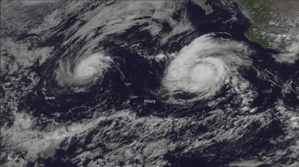
In the Eastern Pacific: Tropical Storm Irwin is located about 1070 mi...1720 km WSW of the southern tip of Baja California with maximum sustained winds...60 mph...95 km/h. Present movement...WSW or 255 degrees at 6 mph...9 km/h.
Hurricane Hilary is located about 515 mi...825 km SW of the southern tip of Baja California with maximum sustained winds...85 mph...140 km/h. Present movement...WNW or 290 degrees at 12 mph...19 km/h.
In the Western Pacific: Typhoon 07w (Noru), located approximately 443 nm north-northwest of Minami Tori Shima, is tracking nwest-orthwestward at 13 knots.
Tropical storm 11w (Nesat), located approximately 422 nm east-northeast of Manila, Philippines, is tracking north-northwestward at 06 knots.
Dangerous Dance

Several storms currently swirl in the Pacific Ocean, with two hurricanes on course for meteorological dance that may end in one dance partner cannibalizing the other.
The bigger storm, Hurricane Hilary, is located several hundred miles south of the Baja California peninsula and has wind speeds of up to 105 mph (165 km/h). Hurricane Irwin is farther west of Hilary and has been weakening, with maximum sustained winds of 80 mph (130 km/h).
Currently, the hurricanes aren't threatening any coastal areas, but they might get locked in a strange dance step known to meteorologists as the Fujiwhara effect. A binary interaction —another name for the Fujiwhara effect —happens when two hurricanes get very close to each other, within about 800 miles (1,290 km), so that their vortices, the spinning centers of the storms, interact.
Two vortices spinning in the same direction will start to orbit around a single center of mass if they get close enough to each other. With two hurricanes that are similar in strength, this center of mass will be the midpoint between the two storms. But if one vortex is stronger, that storm will be closer to the center of the action and could swallow the smaller storm. In this case, Irwin is the smaller storm, and it is expected to pinwheel around the eastern edge of Hilary in the coming days, according to the National Hurricane Center.
NewsBytes:

Germany - Heavy rains led to flooding Wednesday in some parts of northern Germany, forcing some evacuations and prompting residents to pile sandbags in front of their homes to protect themselves from a swollen river. The center of the town of Goslar, in the mountainous Harz region of northern Germany, west of Berlin, was closed off and a hotel and a home for the elderly were evacuated as its central market square was flooded. Elsewhere, streets were flooded and basements had to be pumped dry of water in the Harz region, and two stretches of railway lines were closed.
Salt Late City, Utah, USA - Flooding from an early morning storm led to some road closures, TRAX delays, flooded basements and power outages Wednesday morning. An inch of rain fell in 40 minutes, according to KSL TV meteorologist Dan Guthrie, causing standing water and flooded areas, particularly in the Salt Lake Valley. Several streets turned into rivers. “The sudden occurrence and intensity of this storm is a 200-year event in Salt Lake City,” said Laura Briefer, Department of Public Utilities director, in a released statement.
No comments:
Post a Comment