Saturday 31 August 2013

Earthquakes

Magnitude 5+ Earthquakes - Global

7.0 Earthquake hits the Andreanof Islands in the Aleutian Islands.

No tsunami warning was issued, although authorities are monitoring conditions.

5.8 Earthquake hits Sichuan-Yunnan Border, China.

The earthquake hit a mountainous area of south-western China on Saturday morning, killing at least four people and injuring 10 others. The quake also destroyed 600 residential units and damaged 55,500 others. More than 9,000 residents were forced to relocate.

5.7 Earthquake hits the Andreanof Islands in the Aleutian Islands.

5.5 Earthquake hits the Andreanof Islands in the Aleutian Islands.

5.2 Earthquake hits the Andreanof Islands in the Aleutian Islands.

5.2 Earthquake hits the Andreanof Islands in the Aleutian Islands.

5.2 Earthquake hits the Andreanof Islands in the Aleutian Islands.

5.2 Earthquake hits the Andreanof Islands in the Aleutian Islands.

5.1 Earthquake hits the Banda Sea.

5.1 Earthquake hits the Andreanof Islands in the Aleutian Islands.

5.1 Earthquake hits the Andreanof Islands in the Aleutian Islands.

5.1 Earthquake hits the Andreanof Islands in the Aleutian Islands.

5.1 Earthquake hits the Andreanof Islands in the Aleutian Islands.

5.1 Earthquake hits Sichuan-Yunnan Border, China.

5.0 Earthquake hits the Andreanof Islands in the Aleutian Islands.

5.0 Earthquake hits the Andreanof Islands in the Aleutian Islands.

5.0 Earthquake hits western Xizang, China.

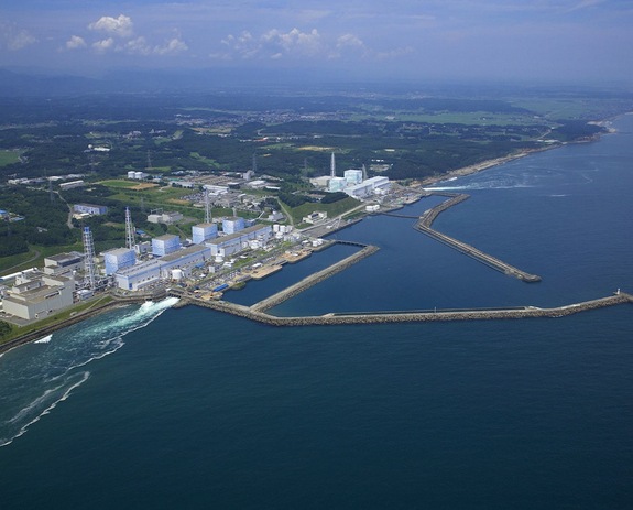
Fukushima Radioactive Plume

The plume of radioactive water in the Pacific Ocean generated by a leak in the Fukushima nuclear power plant crippled by the 2011 earthquake and tsunami will reach the U.S. by 2014, and could help scientists study ocean circulation.

Storms and Floods

Tropical Storms

In the Western Pacific:

Kong-rey is losing its tropical characteristics as it accelerates northeastward over Japan while merging with a frontal system.

In the Eastern Pacific:

Invest 98-E strengthened into Tropical Depression Eleven-E well southwest of Mexico late Friday night. Some slow development is possible over the next day or so before it moves over cooler ocean waters. Tropical Depression Eleven-E is no threat to land.

Disease

Novel Coronavirus - Saudi Arabia (MERS)

WHO has been informed of an additional four laboratory-confirmed cases of Middle East respiratory syndrome coronavirus (MERS-CoV) infection in Saudi Arabia.

Volcanos

Roundup of Global Volcanic Activity:

Veniaminof (Alaska Peninsula, USA): A strong eruptive phase (paroxysm) with lava fountains and associated ash emissions reaching 15-20,000 ft (4.5-6 km) altitude occurred yesterday. This episode of activity, accompanied by elevated levels of continuous tremor, has so far been the strongest since the start of the eruption on 10 June.

Friday 30 August 2013

Earthquakes

Magnitude 5+ Earthquakes - Global

5.8 Earthquake hits New Britain, Papua New Guinea.

5.3 Earthquake hits Fiji.

5.1 Earthquake hits northern Xinjiang, China.

5.1 Earthquake hits Vanuatu.

5.1 Earthquake hits Libertador O'Higgins, Chile.

Storms and Floods

Tropical Storms

In the Western Pacific:

Tropical storm Kong-rey is located about 410 nm southwest of Sasebo, Japan.

Three people in Taiwan perished as a result of heavy rains spawned by a destructive tropical storm. Tropical Storm Kong-Rey battered the island Thursday, dumping more than 500 millimeters (19 inches) of rain on the heavily populated west coast and causing widespread flooding.

In the Eastern Pacific:

Post-Tropical cyclone Juliette is located about 205 mi (330 km) NW of Cabo San Lazaro, Mexico. The final advisory has been issued on this system.

Tropical Storm Juliette blew through the Pacific Mexican tourist resort of Cabo San Lucas early on Thursday, killing one man. Juliette blew down trees and power lines as it blasted across the tourist resorts at the tip of Mexico's Baja California Peninsula.

The storm's maximum sustained winds decreased to near 40 mph (65 kph) near midday Thursday after hitting 50 mph (85 kph) overnight. It was centered about 95 miles (160 kilometers) northwest of Cabo San Lazaro, but it was projected to weaken and curve away from land, into the Pacific. The storm flooded low-lying areas and collapsed at least one house.

Much of the area is without power, including the communities of Todos Santos and Pescadero, as well as parts of Cabo San Lucas and San Jose del Cabo. Firefighters reported helping various people trapped in their cars on flooded streets. One man died because of an electrical shock in a neighborhood where people commonly draw power with jury-rigged, illegal taps into electricity lines. Emergency workers went door to door urging people in high-risk areas to go to shelters, but many refused.

NewsBytes:

Landslide in La Chicharronera village in Honduras has claimed the lives of at least six children and injured two others Wednesday night. Heavy rain caused the landslide. The landslide site is located 93 miles north of the capital city of Tegucigalpa.

Small tornado touches down in Livingston County, Michigan, USA.

Environment

Global Temperature Extremes

The week's hottest temperature was 114.8 degrees Fahrenheit (46.0 degrees Celsius) at Akjoujt, Mauritania.

The week's coldest temperature was minus 108.2 degrees Fahrenheit (minus 77.9 degrees Celsius) at Russia's Vostok Antarctic research station.

Temperatures were tabulated from the more than 10,000 worldwide synoptic weather stations. The United Nations World Meteorological Organization sets the standards for weather observations, and provides a global telecommunications circuit for data distribution.

Wildlife

1.5 Million Roaches Escape Chinese Breeding Farm

At least 1.5 million cockroaches escaped a breeding facility in eastern China’s Jiangsu province, infesting nearby farmland and homes.

The province’s board of health investigators are at a loss on how to rid the region of the pests.

Wang Pengsheng began raising the insects so their extracts could be used as a traditional Chinese medicine treatment for cancer and inflammation, and to allegedly improve immunity.

He had been raising the roaches on a diet of fruits and biscuits when something destroyed the plastic greenhouses he was using for the enterprise.

Local villagers were reported to be worried that the escaped hexapods would damage their crops and bring diseases.

Local authorities were working to calm those fears.

According to the website YinYangHouse.com, roach parts or extracts can renew “joints, sinews and bones, (heal) contusions, fractures and lacerations” and are also used for a “wide variety of blood stasis such as abdominal masses and amenorrhea, (as well as) numb and swollen tongue.”

Ew130830g

Disease

Novel Coronavirus - Saudi Arabia (MERS)

WHO has been informed of an additional two laboratory-confirmed cases of Middle East respiratory syndrome coronavirus (MERS-CoV) infection in Qatar.

US Disease Outbreaks Linked to Vaccine-Shy Parents

The number of Americans requesting exemptions for vaccinations is continuing to rise, a 2012 study found. The current measles outbreak connected to Eagle Mountain International Church case in Newark, Texas, is a perfect example of how diseases that can be controlled through vaccinations are making comebacks in pockets, experts said. Before the outbreak, ministers had encouraged members to question vaccinations; they’ve changed their tune now that 21 people, including a 4-month-old baby, are sick.

Vaccination rates vary throughout the United States, in part because each state has its own requirements for exemption. Outbreaks usually occur where there are clusters of unvaccinated people, Emory University vaccine expert Saad Omer said. So even if an overall vaccination rate is high (in the Texas county home to the megachurch, for example, the overall rate is about 98 percent), a disease can spread quickly throughout a close community such as a school or church with a pocket of unvaccinated people.

Vaccine needle 660

Wildfires

Portugal burns as wildfires rage

Wildfires are continuing to affect Portugal with at least eleven still active in northern and central areas of the country. More than 1,000 firefighters and 250 vehicles are tackling the flames. Around 12.00 local some 500 firefighters are on site trying to tackle the blazes at Serra do Caramulo, with two active fronts, backed by 139 vehicles and five water-dropping aircrafts. Six villages are surrounded by fire. Some of the villagers lost their houses, corrals and cattle. One more female firefighter, 21, died today in the fire at Serra do Caramulo, while two others are seriously wounded and four are reported missing.

In some areas, strong winds are feeding the flames of the forest fires.

The French government is allowing two planes to stay in Portugal until September 3 to aid the relief effort.

Volcanos

Roundup of Global Volcanic Activity:

El Hierro (Canary Islands, Spain): Small earthquakes (mostly below magnitude 2) continue to occur frequently (10-20 per day), mostly under the central part of the island. Right now, this activity seems to be picking up, but it is too early to see if this evolves into another swarm.

Manam (Papua New Guinea): Explosions occurred this morning, producing ash plumes rising to 8,000 ft (2.4 km) altitude, VAAC Darwin reported.

Ijen (East Java, Indonesia): CVGHM reported that during 1 July-25 August diffuse white plumes rose 100-150 m above Ijen's crater, the lake water was light green, and seismicity decreased.

Dukono (Halmahera): VAAC Darwin reported an ash plume from the volcano at 8,000 ft (2.4 km) altitude yesterday morning. This might have originated from a larger than usual explosion. The rarely visited volcano is one of Indonesia's almost permanently active volcanoes and often has strombolian to vulcanian activity.

Ambrym (Vanuatu): A large SO2 plume is drifting NW from the volcano, where at least two lava lakes in the Benbow and Marum craters remain active.

Veniaminof (Alaska Peninsula, USA): The eruption at the intracaldera cone of Veniaminof Volcano continues. The seismicity over the past 24 hours has been characterized by discreet episodic bursts of tremor, likely associated with lava effusion and minor ash emission. Satellite images of the volcano over the past 24 hours have shown prominent thermal signals at the intracaldera cone, although views of the volcano have been infrequent due to cloud cover.

Popocatépetl (Central Mexico): Activity remains low with few (less than 1 per hour) weak emissions of steam and gas. Abundant SO2 output and glow at the summit indicate continuing lava extrusion.

Santa María / Santiaguito (Guatemala): INSIVUMEH reports strong rockfall activity from the steep-sided lava flows, suggesting that several of them are being alimented at the moment. Strong degassing produces a steam column rising up to about 1 km above the dome.

Pacaya (Guatemala): Weak strombolian activity and the effusion of lava flows continues. The activity can be seen from the capital and the coast.

Fuego (Guatemala): The lava flows were no longer active yesterday morning. Activity consisted in weak to moderate strombolian explosions with incandescent material projected to up to 150 m above the crater, and ash plumes of a few 100 m height.

Momotombo (Nicaragua): A swarm of quakes including a shallow magnitude 3.8 felt earthquake occurred yesterday morning (16:38 GMT) at 3.5 km depth under the NW flank of the volcano. There are no reports of other unusual activity at the volcano.

Thursday 29 August 2013

Earthquakes

Magnitude 5+ Earthquakes - Global

5.1 Earthquake hits Fiji.

Storms and Floods

Tropical Storms

In the Atlantic Ocean:

Tropical wave midway between Africa and the Lesser Antilles downgraded - A tropical wave that came off the coast of Africa on Sunday is midway between Africa and the Lesser Antilles Islands. This disturbance is moving westward at 10 - 15 mph, has a modest amount of spin, but has lost nearly all of the limited heavy thunderstorm activity it had. Wednesday the National Hurricane Centre downgraded the 5-day odds of formation of this disturbance from 30% to 20%. The wave could spread heavy rains and gusty winds to the Lesser Antilles Islands as early as Sunday.

A tropical wave expected to emerge from the coast of Africa on Friday and track over the Cape Verde Islands is developed by some models. This wave is expected to take a northwesterly track, and would likely not be able to make the long trek across the Atlantic to threaten North America or the Caribbean Islands.

In the Western Pacific:

Tropical Storm Juliette formed in the Pacific Ocean about 130 miles (210 kilometers) southeast of the resort town of Cabo San Lucas, Mexico.

On the forecast track, the centre of Juliette will continue to move near or along the West Coast of the southern Baja California peninsula early today. Juliette is expected to weaken to a depression tonight.

Tropical storm Kong-rey is located approximately 49 nm east of Taipei, Taiwan.

The outlook now calls for Kong-rey to deviate farther south than earlier forecast, skimming the east coasts of Kyushu, Shikoku and Honshu islands in Japan before exiting the Kanto Plain and dissipating Monday in the western Pacific. Kong-rey will weaken as it interacts with land and moves over cooler northern waters, passing 16 miles south of Yokosuka Naval Base at 5 p.m. Sunday, packing tropical depression-strength 35-mph sustained winds and 46-mph gusts.

Tropical storm Fernand: Mexico landslides, flooding kill 14

Landslides and flooding in Veracruz and Oaxaca have claimed the lives of at least 14 people.

Landslide in Gold Rock in Yecuatla Township buried six homes with nine people inside. Landslides in Tuxpan and Atzalan claimed lives of four others.

Fast-flowing flood waters swept away a man in Oaxaca.

NewsBytes:

Flash flood in an underground cave in western Austria has trapped at least 27 hikers. The flood waters closed the entrance to the cave about 320 kilometres west of Vienna. Emergency crews are in voice contact with those trapped inside the cave, rescue officials said. Rescue workers further added that they are not in danger.

Flash floods in Mali's capital Bamako have claimed the lives of at least 24 people.

Flash floods and heavy monsoon rains have battered Laos, killing at least 20 people, washing away roads and damaging crops.

Global Warming

Spy Satellite Data Reveals Antarctic Ice Vulnerability

Declassified spy satellite imagery of Antarctica dating back to the 1960s has revealed that the world's largest ice sheet may be more susceptible to climate change than once thought.

East Antarctica reaches higher elevations than elsewhere on the continent and experiences some of the coldest temperatures on Earth, hitting well below zero degrees Fahrenheit throughout much of the year. As a result, a massive ice sheet has accumulated, measuring more than 2.5 miles (4 kilometers) thick in some regions, holding enough water to raise global sea level by more than 160 feet (50 meters) if it were to completely melt.

Due to its thickness and high elevation, researchers have regarded the East Antarctic Ice Sheet as relatively stable and more resilient against climate change than the West Antarctic Ice Sheet, which sits much closer to sea level and experiences warmer average temperatures.

Now, researchers from Durham University in the United Kingdom have used declassified spy satellite imagery covering the years from 1963 to 2012 to study changes in the outer margin of the East Antarctic Ice Sheet, and have compared these patterns with climate data from the region. The team has found that periods of expansion and retreat of the ice sheet's glaciers, essentially rivers of ice, appear to correspond with periods of warming and cooling in the atmosphere within the past 50 years.

"We've shown for the first time that these glaciers are in concert with climate," Chris Stokes, a professor of geography at Durham University and an author of the paper, told LiveScience. "So the concern would be that if it does start to get warmer, then we would expect to see the glacier retreat."

While the researchers did note periods of growth and retreat, they did not detect a notable net change in the size of the ice sheet during the study period. Future warming could, however, push the region into a more significant retreat phase that could potentially cause net reduction in ice thickness in the region, Stokes said.

Glacier

Environment

Cooler Pacific Ocean May Explain Climate Change Paradox

Cooling sea-surface temperatures in the tropical Pacific Ocean — a phase that is part of a natural warm and cold cycle — may explain why global average temperatures have stabilized in recent years, even as greenhouse gas emissions have been warming the planet, according to new research.

The findings suggest that the flattening in the rise of global temperatures recorded over the past 15 years are not signs of a "hiatus" in global warming, but are tied to cooling temperatures in the tropical or equatorial Pacific Ocean. When the tropical Pacific naturally switches back into a warm phase, the long-term trends in global warming, including more steeply rising global temperatures, will likely increase, said study co-author Shang-Ping Xie, a climate scientist at the University of California, San Diego.

"The engine driving atmospheric circulation on global scales resides in the tropical Pacific," Xie told LiveScience. "When the natural cycle shifts the next time to a warmer state, we're going to see more extreme warming on the global scale."

In early May, a carbon dioxide monitor in Hawaii recorded the proportion of carbon dioxide in the atmosphere as being more than 400 parts per million (ppm) for the first time in human history, breaking a 3-million-year-old record. (Parts per million means that, in this example, for every million molecules of air, 400 of them are carbon dioxide.) But, over the past 15 years, global average temperatures have stabilized rather than sharply increased, as previous predictions suggested they should have, mystifying climate scientists and adding fuel to the fire for climate change skeptics.

"We had this puzzle — the concentration of carbon dioxide was over 400 ppm, last year we had record summer heat waves in the U.S., record retreat of Arctic sea ice. All of these things are consistent with the general warming of the climate," Xie said. "Yet, if you plot the global temperature, you see a flattening average over the last 15 years. On the one hand, scientists are saying carbon dioxide is causing the general rise of global temperatures, but on the other hand, in recent years there is no warming, so something very strange is going on."

Xie and his colleagues set out to solve this mystery using climate models to reproduce the long- and short-term trends based on global climate records from the past 130 years. The researchers found that sea-surface temperatures in the tropical Pacific Ocean, in spite of anthropogenic or manmade effects of global warming, were key ingredients in creating the flattening global temperatures seen in the past 15 years.

"In our model, we were able to show two forces: anthropogenic forces to raise global average temperature, and equatorial Pacific cooling, which tries to pull the temperature curve down, almost like in equilibrium," Xie said.

The effect is similar to the El Niño and La Niña cycles, which are parts of a natural oscillation in the ocean-atmosphere system that occur every three to four years, and can impact global weather and climate conditions, Xie explained. El Niño is characterized by warmer-than-average temperatures in the waters of the equatorial Pacific Ocean, while La Niña typically features colder-than-average waters.

The warm and cool phases in the Pacific Ocean studied by Xie and his colleagues appear to last much longer than the El Niño and La Niña cycles. Previously, the Earth experienced cooling in the tropical Pacific from the 1940s to the 1970s, before oscillating into a warm state from the 1970s to the 1990s.

Current scientific models are unable to predict when the current cooling period will end, Xie said, but when the ocean swings back into a warm phase, parts of the planet may experience warmer temperatures.

"The equatorial Pacific Ocean is associated with distinct regional patterns, like the Pacific coast of North America," Xie said. "Because of equatorial cooling, this area has not been warming as rapidly as before, but when the equatorial Pacific shifts into a warm state, those regions might expect rapid warming, on the order of 2 degrees Celsius [3.6 degrees Fahrenheit] over 15 years."

Earth temperature

Wildfires

Wildfires in California. USA

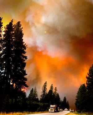
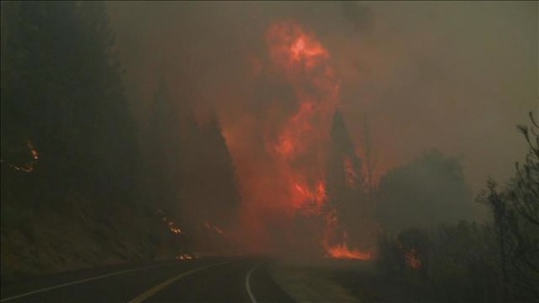
California's massive Rim Fire in Yosemite National Park continues to grow, but firefighters took advantage of less windy conditions on Tuesday and had attained 23% containment of the fire as of 9:20 am EDT on Wednesday. The Rim Fire has burned 187,000 acres. This ranks as the 7th largest fire in state history, and largest fire on record in the California Sierra Mountains.

California's Rim Fire as captured by a member of the International Space Station on August 26, 2013. Lake Tahoe is visible at the top, and smoke from the fire obscures the northern portion of Yosemite National Park, and streams into Nevada. Image credit: NASA.

Rimfire iss aug26

Disease

Novel Coronavirus - Saudi Arabia (MERS)

WHO has been informed of an additional eight laboratory-confirmed cases of Middle East respiratory syndrome coronavirus (MERS-CoV) infection in Saudi Arabia.

Polio in Pakistan

Health officials in Pakistan on Wednesday warned of a serious polio outbreak after the disease was detected in 16 children in a tribal district.

Volcanos

Rome airport volcano erupts!

A small volcano vent has suddenly appeared near Rome’s International Fiumicino airport.

The geyser-like vent has been shooting out steam and mud over the weekend. The little volcano is nearly two metres wide.

Geologists and engineers expect it to be a fumarole, a vent of steaming-hot hydrothermal water that erupts at the Earth's surface.

Volcano rome airport

Wednesday 28 August 2013

Earthquakes

Magnitude 5+ Earthquakes - Global

6.1 Earthquake hits the Kermedec Islands off New Zealand.

5.9 Earthquake hits the North Pacific Ocean.

5.5 Earthquake hits southern Sumatra, Indonesia.

5.1 Earthquake hits central Alaska.

5.0 Earthquake hits central Iran.

5.0 Earthquake hits off the east coast of Honshu, Japan.

5.0 Earthquake hits Fiji.

5.0 Earthquake hits Sichuan-Yunnan border region, China.

Fukushima Update

Japan's nuclear regulator has upgraded the rating of a leak of radiation-contaminated water at its tsunami-wrecked nuclear plant to a "serious incident" on an international scale.

Nuclear Regulation Authority official Yukiko Fukui said on Wednesday the severity of the August 19's leak was raised to level 3 from the original level 1.

300 tons (300,000 liters, 80,000 gallons) of water had escaped from one tank and some may have reached the sea through a rainwater gutter.

Storms and Floods

Tropical Storms

In the Western Pacific:

Tropical storm Kong-rey is located approximately 275 nm south-southeast of Taipei, Taiwan. Forecast to turn and reach Japan on Friday.

'Nando' [Kong-rey] won't make landfall in the Philippines. The cyclone will continue to move upward via the eastern side of the country and head towards Taiwan by Thursday. Public storm warning signal number 1 has been raised over the Batanes Group of Islands. The cyclone will enhance the southwest monsoon and bring light to moderate rains and thunderstorms over Southern Luzon, Metro Manila and Western Visayas.

Wildfires

Wildfires in California. USA

More than 3,500 firefighters are still battling a raging wildfire in California's Yosemite National Park, which has rained ash on the reservoir that is the chief source of water to San Francisco.

Wildfires rage in Spain and Portugal.

Firefighters and local residents struggled on Tuesday to tackle raging wildfires amid hot weather and strong night-time winds that have consumed large swathes of forest in Portugal and Spain and cost the lives of four emergency workers.

Volcanos

Roundup of Global Volcanic Activity:

Kliuchevskoi (Kamchatka): A small lava flow has started to descend on the upper northern flank of the volcano. Sometimes intense strombolian continues at the summit vent. Glowing blocks from the lava flow often detach from the front and roll down the steep slope of the volcano. No significant ash emissions have occurred so far.

Tolbachik (Kamchatka): The eruption seems to be coming to an end. Seismic activity dropped from still moderately high levels (2.4 mcm/s) to very low (0.12 mcm/s) on 24 Aug, and the effusion of lava has stopped. No incandescence was spotted in the area of the vent during the past days. The Aviation Colour Code was lowered to yellow.

Sakurajima (Kyushu, Japan): Activity remains at high levels. Over the past 24 hours, the volcano has had 8 explosions recorded by VAAC Tokyo, with ash plumes rising to up to 12,000 ft altitude. The following shows an explosion this morning seen from Kagoshima:

Suwanose-jima (Ryukyu Islands): The volcano has entered an eruptive phase with frequent explosions, which over the past 2 days produced several ash plumes rising as high as 12,000 ft (3.6 km) altitude.

Manam (Papua New Guinea): Another ash plume was spotted earlier today reaching 10,000 ft and suggesting that the volcano has stepped up its activity recently.

Popocatépetl (Central Mexico): Activity has been low over the past days with little changes overall. The volcano continues to produce important degassing and has occasional small explosions. Glow at the summit can be seen when the weather is clear, indicating that lava continues to slowly extrude in the crater.

Santa María / Santiaguito (Guatemala): A moderate explosion took place yesterday morning at 03:24 h local time, generating an eruption column rising 1.3 km, a pyroclastic flow on the SW flank of the dome, and an ash plume that drifted southwest and caused ashfall on Palajunoj. The viscous lava flow on the southern flank of the dome remained active.

Pacaya (Guatemala): INSIVUMEH reports ongoing mild strombolian activity and the appearance of a new lava flow yesterday. The explosions occurred at rhythms of 4-10 minute intervals and ejected glowing lava to about 75 m height. The lava flow on the western flank of the Mackenney crater reached a length of 150-200 m. Judging from the seismogram, activity has decreased a bit today.

Fuego (Guatemala): Activity has not seen significant changes over the past days. Mild to moderate explosions (14 during 26-27 Aug counted) produce ash plumes of 200-500 m height and weak to moderate glowing avalanches of bombs on the upper slopes.

Tuesday 27 August 2013

Earthquakes

Magnitude 5+ Earthquakes - Global

5.4 Earthquake hits the Kuril Islands.

Storms and Floods

Tropical Storms

In the Atlantic Ocean:

Fernand has moved inland over Mexico and is currently located sixty miles from Veracruz, Mexico. The system is ninety miles from Tuxpan, with maximum winds of 30kts. TS Fernand is moving slowly towards the NW at 8kts.

Fernand is expected to weaken and eventually dissipate over the next 12-18hrs over Mexico.

In the Western Pacific:

Tropical Storm Kong-rey has formed. Its centre of circulation is offshore but thunderstorms are bursting on the southwest side of that, which could result in heavy rain in the flash-flood-prone northern Philippines.

Kong-rey (Nando) is expected to accelerate toward Japan by later this week but weaken and become non-tropical in the process.

NewsBytes:

A rain-triggered landslide in Yiliang in Yunnan province, China damaged part of the People's Hospital, Monday morning. Patients and residents were evacuated. No casualties have been reported.

Yunnan china landslide hospital

Disease

Foot and Mouth Disease in Eastern Russia

Cases of foot-and-mouth disease (FMD) involving several hundred cattle and sheep have been reported in two villages in the Amur region of eastern Russia.

Dealing with the outbreaks has been made difficult by severe flooding in the area, according to the National Veterinary Authority.

Bubonic Plague in Kyrgyzstan

Kyrgyzstan’s health officials are on alert after a local teenager died of bubonic plague caught from eating barbecued marmot, the apparent vector for the deadly disease.

A medical check confirmed a 15-year-old boy, who died last Thursday, died of bubonic plague, Kyrgyzstan’s Health Minister said Monday.

The teenager told doctors upon hospitalization that he got sick after eating marmot meat he ate while visiting relatives in the country’s south.

The 105 people Isakunov contacted since his ill-fated rodent meal have all been quarantined, although none have showed symptoms of the disease so far.

Kyrgyzstan’s sanitary services have launched a marmot extermination campaign in the country in response.

Bubonic plague – the disease behind the Black Death epidemic that ravaged Europe in the 14th century – is transmitted by fleas living on small rodents. Humans can catch the disease through flea bites or close contact with infected rodents, such as dressing or consuming their meat. It is transmitted between people via coughs or sneezes once they are infected.

Though no major epidemics of bubonic plague have taken place since the early 20th century, small-scale outbreaks of the disease – which can be treated by antibiotics – continue to occur across the world, particularly in Asia. Mountainous Kyrgyzstan last saw a death from a bubonic plague in 1981, though no epidemic followed.

Monday 26 August 2013

Earthquakes

Magnitude 5+ Earthquakes - Global

5.6 Earth hits the north Pacific Ocean.

5.4 Earthquake hits the southwest Indian Ridge.

5.1 Earthquake hits the Kuril Islands.

5.0 Earthquake hits northern Colombia.

Earthquakes

Magnitude 5+ Earthquakes - Global

5.6 Earth hits the north Pacific Ocean.

5.4 Earthquake hits the southwest Indian Ridge.

5.1 Earthquake hits the Kuril Islands.

5.0 Earthquake hits northern Colombia.

Storms and Floods

Tropical Storms

In the Atlantic Ocean:

Tropical storm Fernand is located about 5 mi (10 km) N of Veracruz, Mexico. Tropical Storm Warning is in effect for the Gulf Coast of Mexico from Veracruz northward to Barra de Nautla. Some additional strengthening is possible before Fernand makes landfall along the Gulf Coast of Mexico early this morning.

In the Eastern Pacific:

Post-Tropical storm Ivo is located about 190 mi (310 km) WNW of Cabo San Lucas, Mexico. The remnants of Ivo are expected to produce total rainfall accumulations of 1 to 3 inches, with possible isolated maximum amounts of 5 inches, across the central and northern portions of the Baja California peninsula. Moisture from this system will also spread into the southwestern United States during the next day or so, bringing a threat of heavy rain and flash flooding. The last advisory has been issued on this system.

In the Western Pacific:

Tropical Depression Fourteen is located approximately 300 nm east-northeastward of Manila, Philippines.

Philippines - Cyclone develops near Surigao, named 'Nando'. "Nando" is the 14th cyclone to enter the Philippine Area of Responsibility this year and the fourth this August.

Punjab's Chenab River floods 170 villages

170 villages have been flooded along Larkana Aqil Agani Loop embankment in Punjab, Pakistan.

The water flow at Head Panjnad in the river Chenab was recorded at 3,00,000 cusecs.

According to the disaster management officials, Pakistan floods and heavy monsoon rains have claimed the lives of 178 people and affected 1.5 million in the last three weeks. More than 350 relief camps have been set up in Punjab, Sindh and Balochistan areas of Pakistan.

14163 687141434647750 2145868325 n

NewsBytes:

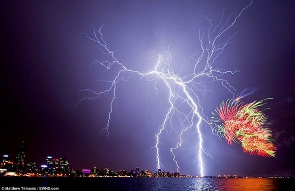
Lightning strike has claimed the life of two brothers on a beach in northern Colombia; and lightning in Jefferson County in eastern Oregon, USA has injured at least one person.

Image of lightning over Sydney Harbour wit Fireworks

1234603 687143234647570 1667619153 n

Global Warming

Rising ocean acidity will exacerbate global warming

German scientists say they've identified a previously overlooked factor in climate change.

In a study published today, they say one effect of global warming is that the oceans will release less of a gas which helps shield the Earth from the sun's radiation. Carbon dioxide soaked up by seawater will cause plankton to release less cloud-forming compounds back into atmosphere.

The slow and inexorable increase in the oceans’ acidity as they soak up carbon dioxide from the atmosphere could itself have an effect on climate and amplify global warming, according to a new study. Acidification would lead certain marine organisms to emit less of the sulphur compounds that help to seed the formation of clouds and so keep the planet cool.

Atmospheric sulphur, most of which comes from the sea, is a check against global warming. Phytoplankton — photosynthetic microbes that drift in sunlit water — produces a compound called dimethylsulphide (DMS). Some of this enters the atmosphere and reacts to make sulphuric acid, which clumps into aerosols, or microscopic airborne particles. Aerosols seed the formation of clouds, which help cool the Earth by reflecting sunlight.

As more CO2 enters the atmosphere, some dissolves in seawater, forming carbonic acid. This is decreasing the pH of the oceans, which is already down by 0.1 pH units on pre-industrial times, and could be down by another 0.5 in some places by 2100. And studies using 'mesocosms' — enclosed volumes of seawater — show that seawater with a lower pH produces less DMS2. On a global scale, a fall in DMS emissions due to acidification could have a major effect on climate, creating a positive-feedback loop and enhancing warming.

Researchers agree that despite the dangers of extrapolating data accumulated over a relatively short time to changes that occur over decades, it remains important to recognize that marine organisms will be affected by environmental changes and that this may impact the climate in return. CO2 that is absorbed by the ocean should be considered to be climate-relevant.

HIRES small C0060535 Marine phytoplankton Diatom bloom SPL

Wildfires

Wildfires in California. USA

Yosemite National Park Wildfires Continue to Spread

The California wildfire is threatening a major reservoir providing 85% of San Francisco's water. The fire is burning some four miles away from the reservoir which serves some 2.6 million customers. More than 5000 homes in danger. Only 7% contained. So far it is the 16th-largest wildfire on record in California. The blaze is also threatening power lines that bring electricity to San Francisco.

Evacuations, some voluntary and some mandatory, are taking place.

The "Beaver Creek" fire in Idaho has destroyed some 45,000 hectares near the ski resort of Sun Valley. Meanwhile, five wildfires in Yellowstone National Park have scorched about 18 square miles of mostly remote areas.

Disease

Novel Coronavirus - Saudi Arabia (MERS)

The global Middle East Respiratory Syndrome coronavirus (MERS-CoV) outbreak has topped 100 cases this week as the Centers for Disease Control and Prevention (CDC) put the total count at 103 as of Friday.

The Saudi Arabia Ministry of Health announced registering two new virus-injured incidences in Asir.

Volcanos

Roundup of Global Volcanic Activity:

Monte Albano (Italy): What appears to be a new fumarole appeared near Rome's International Fiumicino airport Saturday morning. A vent producing small geyser-like fountains of steam, water and mud suddenly opened in the ground near a road crossing near Fiumicino. Geologists are currently examining the phenomenon. It is still a bit unclear whether it is not a man-made accident caused by a broken pipe or similar (which might well be the case). As La Repubblica statess, first inspections however indicate that ii is in fact a new natural vent. Obviously, there are also already some speculations whether it could be related to volcanic activity.

Kliuchevskoi (Kamchatka): Relatively intense strombolian activity continues at the summit. Bright glow can be seen at night. Both webcam images and MODIS hot spot data indicate the occurrence of hot avalanches on the slopes of the volcano as well.

Suwanose-jima (Ryukyu Islands): An explosion at 01:54 GMT was reported by VAAC Tokyo earlier today. The height of the ash plume could not be determined.

Rabaul (Tavurvur) (New Britain, Papua New Guinea): Mild to moderate explosive activity continues. During the past days, several ash plumes reaching 6,000 ft (1,8 km) altitude were reported. MODIS data show a hot spot at Tavurvur cone.

Bagana (Bougainville Island, Papua New Guinea): A hot spot remains visible at the volcano, indicating that some activity continues. This is likely mostly effusive in style, because no recent significant ash emissions have been detected.

Manam (Papua New Guinea): Activity at the volcano continues. An explosion earlier today produced an ash plume rising to 10,000 ft (3 km) altitude extending 80 nautical miles to the NW, VAAC Darwin reported. A recent NASA satellite image from 21 August shows two active vents at the summit of the stratovolcano, possibly containing lava lakes.

Sunday 25 August 2013

Earthquakes

Magnitude 5+ Earthquakes - Global

5.2 Earthquake hits Tonga.

5.1 Earthquake hits off the west coast of Sumatra, Indonesia.

5.1 Earthquake hits the Kermedec Islands off New Zealand.

5.0 Earthquake hits Tajikistan.

5.0 Earthquake hits Seram, Indonesia.

5.0 Earthquake hits east of the Izu Islands off Japan.

More Troubling Developments at Fukushima, Japan

Contaminated water from earthquake-damaged Japanese nuclear plant could could taint Pacific Ocean. Deep beneath Fukushima's crippled nuclear power station a massive underground reservoir of contaminated water that began spilling from the plant's reactors after the 2011 earthquake and tsunami has been creeping slowly toward the sea. Now, two-and-a-half years later, experts fear it is about to reach the Pacific and greatly worsen what is fast becoming a new crisis at Fukushima: the inability to contain vast quantities of radioactive water.

The looming crisis is potentially far greater than the discovery earlier this week of a leak from a tank used to store contaminated water used to cool the reactor cores. That 300-ton (80,000 gallon) leak is the fifth and most serious since the disaster of 2011. But experts believe the underground seepage from the reactor and turbine building area is much bigger and possibly more radioactive, confronting the plant's operator, Tokyo Electric Power Co., with an invisible, chronic problem and few viable solutions. Many also believe it is another example of how TEPCO has repeatedly failed to acknowledge problems that it could almost certainly have foreseen - and could have taken action to mitigate before they got out of control.

It remains unclear what the impact of the contamination on the environment will be because the radioactivity will be diluted as it spreads further into the sea. Most fishing in the area is already banned.

To keep the melted nuclear fuel from overheating, TEPCO has rigged a makeshift system of pipes and hoses to funnel water into the broken reactors. The radioactive water is then treated and stored in the aboveground tanks that have developed leaks. But far more leaks into the reactor basements during the cooling process — then through cracks into the surrounding earth and ground water.

The turbine buildings at the Fukushima Dai-ichi plant are about 150 meters (500 feet) from the ocean. The contaminated underground water is spreading toward the sea at a rate of about 4 meters (13 feet) a month.

Storms and Floods

Tropical Storms

In the Eastern Pacific:

Tropical storm Ivo is located about 290 mi (465 km) W of Cabo San Lucas, Mexico. Swells generated by Ivo still are affecting the southern portion of the Baja California peninsula. These swells are expected to subside on Sunday. Ivo is expected to become a remnant low on Sunday.

Winds and rain from Ivo are spreading across portions of Mexico's Baja California peninsula. The National Hurricane Center in Miami said early Saturday that Ivo was located about 185 miles (300 kilometers) west of Cabo San Lucas. It had maximum sustained winds of 45 mph (75 kph) and was moving north-northwest at 12 mph (19 kph).

A tropical storm warning is in effect for the Pacific coast of the peninsula from Punta Abreojos to Cabo San Lucas, and for the Gulf of California coast of the peninsula from Loreto to Cabo San Lucas. A tropical storm watch is in effect for the Pacific coast of Baja California north of Punta Abreojos to Punta Eugenia. The Hurricane Center called Ivo a large storm and said it would likely bring more rain as well as surf swells.

In the Western Pacific:

Tropical storm Pewa is located approximately 552 nm northward of Wake Island.

Floods in North-East China

A river flood has killed 76 people and another 88 remain missing in Fushun.

At least 21 construction workers in north-west China have been killed by flash flooding that swept through a remote part of the province of Qinghai. They were "washed away" after a sudden torrential rain storm.

The area lies in high mountains 2,500km (1,500 miles) west of Beijing. Flash floods are a frequent threat both to residents there and to travellers drawn by its mountain scenery. On Monday at least 105 people were killed and 115 were missing after floods and a typhoon hit various parts of north-eastern and southern China. The Chinese government has called for "persistent efforts" to save people in the north-east from what was described as "The worst floods in decades".

NewsBytes:

At least one person has been missing in floods in Gotsu in Shimane Prefecture in Japan. Exceptional 201 mm of rain in three hours also caused mudslides in the area and collapsed one house each in Gotsu and Hamada city. An evacuation order has been issued for around 36,000 residents as of 9:30 a.m.

Wildfires

Wildfires in California. USA

The wildfire in Stanislaus National Forest in the US continued to expand, growing to 164 sq miles (424 sq km) by Friday morning. The Governor of California declared a state of emergency and the fire has forced thousands of residents and tourists to flee.

More than 2,000 firefighters have been tackling the blaze, known as the Rim Fire, which has encroached into Yosemite National Park, one of the most popular tourist attractions in California.

After burning for nearly a week on the edges of Yosemite, the massive wildfire has now crossed into it, and firefighters have barely begun to contain it.

The governor issued a declaration of emergency late Friday for San Francisco 150 miles away because of the threat the fire posed to utility transmission to the city, and the fire caused smoke warnings and event cancellations in Nevada as smoke blew over the Sierra Nevada and across state lines. Health district officials raised an air quality alert to the "red" unhealthy level, Friday afternoon in Reno, Nevada.

Yosemite stopped issuing backcountry permits to backpackers and had warned those who already had them to stay out of the area.

1013275 686896494672244 757064338 n

Drought

Drought in Yemen

Yemen is facing a severe water crisis with some estimates suggesting the capital, Sanaa, could run dry in 10 years.

Saturday 24 August 2013

Earthquakes

Magnitude 5+ Earthquakes - Global

5.7 Earthquake hits Tonga.

5.0 Earthquake hits the Kermedec Islands off New Zealand.

5.0 Earthquake hits Kyrgyzstan.

5.0 Earthquake hits Tajikistan.

Storms and Floods

Tropical Storms

In the Eastern Pacific:

Tropical Storm Ivo forms in the eastern Pacific and continued on its path along the west coast of Mexico on Saturday.

As of 11 a.m. ET, the storm had maximum sustained winds of 45 mph and was moving to the north-northwest at 12 mph. It's located about 225 miles west of Cabo San Lucas, Mexico.

The government of Mexico has issued tropical storm warnings and watches for most of the coast of Baja California.

While most tropical storms and hurricanes that form in the eastern Pacific have little or no impact on the USA, this one could bring rain and flooding to the Southwest US.

Sudan's worst floods for 25 years

Forty-eight people have been killed and more than 500,000 affected by the worst floods in Sudan in quarter of a century.

The region around the capital, Khartoum, was particularly badly hit, with at least 15,000 homes destroyed and thousands of others damaged. Across Sudan, at least 25,000 homes are no longer habitable. A UN official described the situation as a disaster.

The flooding, caused by continuous rains, has damaged public buildings, including schools, clinics, offices, shops, markets and water and sanitation facilities. Roads have been inundated, disrupting transport.

One of the major health worries is the collapse of more than 53,000 latrines; the World Health Organisation (WHO) has warned of an increase in malaria cases in the past two weeks.

NewsBytes:

Landslides in Laos have claimed the lives of at least sixteen people and washed away 38 houses. The landslides were caused by two days of heavy rain and buried several houses in Pakbaeng district, Oudomxay province in Laos.

Over 15 villages were submerged in flood waters on Friday affecting a population of ten thousand in the Malda district of West Bengal, India.

Friday 23 August 2013

Earthquakes

Magnitude 5+ Earthquakes - Global

5.6 Earthquake hits Antofagasta, Chile.

5.2 Earthquake hits southern Sumatra, Indonesia.

5.1 Earthquake hits south of Bali.

5.0 Earthquake hits the South Sandwich Islands.

Japan Earthquake & Tsunami of 2011: Amazing facts

Here are some of the amazing facts about the Japan earthquake and tsunami.

The earthquake shifted Earth on its axis of rotation by redistributing mass, like putting a dent in a wobbling top.

The temblor also shortened the length of day by about a microsecond.

More than 1,000 aftershocks have hit Japan since the earthquake, the largest a magnitude 7.9.

About 250 miles (400 km) of Japan's northern Honshu coastline dropped by 2 feet (0.6 meters). The jolt moved Japan's main island of Honshu eastward by 8 feet (2.4 meters).

The Pacific Plate slid westward near the epicenter by 79 feet (24 m).

In Antarctica, the seismic waves from the earthquake sped up the Whillans Ice Stream, jolting it by about 1.5 feet (0.5 meters).

The tsunami broke icebergs off the Sulzberger Ice Shelf in Antarctica.

As the tsunami crossed the Pacific Ocean, a 5-foot high (1.5 m) high wave killed more than 110,000 nesting seabirds at the Midway Atoll National Wildlife Refuge.

In Norway, water in some fjords pointing northeast toward Japan (up and over the pole) sloshed back and forth as seismic waves from the earthquake raced through.

The earthquake produced a low-frequency rumble called infrasound, which traveled into space and was detected by the Goce satellite.

Japan tsunami damage

Storms and Floods

Tropical Storms

In the Western Pacific:

Tropical storm Pewa is located approximately 242 nm northeastward of Wake Island.

Typhoon Trami hit Southeast China on Wednesday as a Category 1 storm with 85 mph winds, after dumping torrential rains in the Philippines that killed 17 people. Trami's rains are creating new flooding flooding problems for a Chinese nation already reeling from a week of deadly floods that have left over 250 people dead or missing. Twenty-one of the deaths came on Tuesday evening, due to a flash flood in northwest China's Qinghai Province.

Much of Hong Kong was shrouded in a haze on Thursday as a continental air stream associated with Tropical Cyclone Trami contributed to the trapping of pollutants in the city’s air. The air pollution index remained a “very high level” for most parts of the city on Thursday as smog and pollutants accumulated.

In the Eastern Pacific:

Tropical depression Nine-E is located about 390 mi (630 km) SSW of Cabo San Lucas, Mexico. Forecast to become a tropical storm on Friday.

Severe Flooding in Colorado, USA

Severe flash floods have been reported throughout Southern Colorado Thursday night.

Parts of Voyager Parkway, Black Forest Road, Squirrel Creek Road, West Colorado Avenue and Bandley Road have been closed. Power outages have also been reported in Colorado Springs.

There are reports of serious road damage in Black Forest.

The flood warning has been issued for Fountain Creek through El Paso County and into Pueblo County until Friday afternoon.

1185877 685854244776469 286397714 n

NewsBytes:

Flash floods in Odisha, India have claimed lives of two people and displaced about 1,000 others,


Nature - Images

Interesting Images:

Awesome picture of a fallstreak hole, also known as a punch hole cloud.

1150943 685754544786439 1911341273 n

Environment

Global Temperature Extremes

The week's hottest temperature was 121.0 degrees Fahrenheit (49.4 degrees Celsius) at Death Valley, California, USA.

The week's coldest temperature was minus 96.9 degrees Fahrenheit (minus 71.6 degrees Celsius) at Russia's Vostok Antarctic research station.

Temperatures were tabulated from the more than 10,000 worldwide synoptic weather stations. The United Nations World Meteorological Organization sets the standards for weather observations, and provides a global telecommunications circuit for data distribution.

Volcanos

Roundup of Global Volcanic Activity:

Sakurajima (Kyushu, Japan): On 21 August, the volcano had at least 8 (!) vulcanian-type explosions with ash plumes rising up to 15,000 ft (4,5 km) altitude that often drifted over the bay and Kagoshima city, causing ash fall there. Some of the explosions can be seen on the following time-lapse video. The volcano has been in an elevated state of activity during the past weeks. A significant hot spot is visible on MODIS data, suggesting that magma levels are high in the crater and the presence of significant amounts of still hot fresh deposits on the flanks.

Santa María / Santiaguito (Guatemala): A major eruption occurred yesterday evening. Starting at 17:45 (local time), the top part of the Caliente lava dome collapsed and produced a series of relatively large pyroclastic flows and explosions. Ash plumes rose more than 2 km to elevations of 4 km altitude. The cause of the eruption was likely the accumulation of pressurized magma and gas under the dome composed of viscous (solid) lava.

Wildfires

Wildfires in Portugal

One firefighter dead, 6 hurt in wildfire in a remote and hilly region in Portugal. Information was not immediately available about what happened to the firefighters sent on Thursday to put out a fire in the municipality of Tondela, in north central Portugal.

Numerous fires have broken out in three regions of north central and northern Portugal in recent days, and 700 firefighters are battling the blazes.

Significant Wildfires Burning in the Western US

Fifty large wildfires burned un-contained Thursday in the U.S.

Notable fires, with location, containment, size, fuel, personnel and cost to date:

—Rim, Stanislaus National Forest, Calif.; 2 percent contained, 84 square miles, timber and brush, 1,356 personnel, $2.8 million.

—Lolo Creek Complex, outside Lolo, Mont.; 0 percent contained, 14.8 square miles, timber and grass, 508 personnel, $805,000.

—Government Flat Complex, outside The Dalles, Ore.; 15 percent contained, 17 square miles, timber and grass, 853 personnel, $4.6 million.

—Beaver Creek , outside Sun Valley, Idaho; 47 percent contained, 172 square miles, timber and brush, 1,721 personnel, $16.6 million.

—American, Tahoe National Forest, Calif.; 60 percent contained, 26 square miles, timber, 1,866 personnel, $14.5 million.

—Eagle, Okanogan/Wenatchee National Forest, Wash.; 10 percent contained, 1.2 square miles, 596 personnel, $1 million.

—Spring Peak, Humboldt-Toiyabe National Forest, Nev.; 68 percent contained, 22 square miles, pinyon pine, juniper and brush; 270 personnel, $1 million.

—Mississippi, outside Delta; containment not available, 105 square miles, timber brush and grass; 335 personnel, $4.4 million.

Thursday 22 August 2013

Earthquakes

Magnitude 5+ Earthquakes - Global

5.0 Earthquake hits the northern Mid-Atlantic ridge.

At least one person has been missing after a 4.4 magnitude earthquake caused a landslide in Ancona, Italy. The Earthquake also damaged one government building and a fire station.

Storms and Floods

Tropical Storms

In the Western Pacific:

Tropical storm Pewa is located approximately 242 nm northeastward of Wake Island.

Tropical storm Trami is located approximately 107 nm west-northwestward of Taipei, Taiwan.

Severe Tropical Storm Trami has struck a heavily populated northern Taiwan, prompting schools and offices to close down as heavy rains - up to 2 feet - triggered landslides. A deadly combination of monsoon rains and heavy rainfall from Tropical Storm Trami swamped the northern Philippines on Monday and Tuesday.

Typhoon Trami batters China - Packing winds of 126 km/h, the 12th tropical storm to hit China this year made landfall in the coastal areas of Fuqing City early on Thursday. Trami has slammed into China, bringing more rain and threatening to worsen severe flooding that has so far left 575 dead and 340 missing.

NewsBytes:

Floods in Darfur, Sudan have claimed the lives of at least five people and injured seventeen others.

Environment

Global sea level rise temporarily dampened by 2010-11 Australia floods

Three atmospheric patterns came together above the Indian and Pacific Oceans in 2010 and 2011. When they did, they drove so much precipitation over Australia that the world's ocean levels dropped measurably.

Unlike other continents, the soils and topography of Australia prevent almost all its precipitation from flowing into the ocean.

Australia's vast interior, called the Outback, is ringed by coastal mountains and is often quite dry.

Because of the low-lying nature of the continent's eastern interior, and the lack of river runoff in its western dry environment, most of the heavy rainfall of 2010-11 remained inland rather than flowing to the oceans.

While some of it evaporated in the desert sun, much of it sank into the dry, granular soil of the Western Plateau or filled the Lake Eyre basin in the east.

The 2010-11 event temporarily halted a long-term trend of rising sea levels caused by higher temperatures and melting ice sheets, according to a team of researchers at the National Center for Atmospheric Research (NCAR) in Boulder, Colo., and other institutions.

Now that the atmosphere's circulation has returned to its previous patterns, the seas are again rising.

The scientists conclude that the Outback region in Australia played a crucial role in trapping a large amount of rainfall when widespread floods occurred over the continent.

The researchers concluded that the smallest continent in the world can affect sea level worldwide. Its influence is so strong that it can temporarily overcome the background trend of rising sea levels we see with climate change.

As the climate warms, the world's oceans have been rising in recent decades by just over three millimetres annually.

This is partly because heat causes water to expand, and partly because runoff from retreating glaciers and ice sheets is making its way into the oceans.

But for an 18-month period beginning in 2010, the oceans mysteriously dropped by about seven millimetres, more than offsetting the annual rise.

Fasullo and co-authors published research results last year demonstrating that the reason was related to the increased rainfall over tropical continents.

They also showed that the drop coincided with the atmospheric oscillation known as La Niña, which cooled tropical surface waters in the eastern Pacific and suppressed rainfall there--while enhancing it over portions of the tropical Pacific, Africa, South America and Australia.

However, an analysis of the historical record showed that past La Niña events only rarely accompanied such a pronounced drop in sea level.

Nature - Images

Interesting Images:

University of Alaska, Fairbanks, graduate student Jason Ahrns captured stunning images of red sprites during several flights over the Midwest this summer aboard the National Center for Atmospheric Research’s Gulfstream V research plane.

Red sprites 2 columnar

Red sprites 4 big red

Wildfires

Wildfires - USA

Strong and shifting winds are pushing an Oregon wildfire that has burned across 5,000 acres in the Columbia River Gorge, forcing the evacuation of a several dozen structures.

For the second time in as many days, residents of Atlanta, Idaho, were told to evacuate late Aug. 20 as the Little Queens Fire grew in strength, burning more than 9,500 acres and reported to be within two miles of the town's limits. Officials had previously said that they believed the fire was human-caused.

Meanwhile, the nation's highest wildfire priority, the Beaver Creek Fire, continues to rage in Blaine County, burning more than 106,000 acres. Close to 2,000 firefighters have been working the fire lines and as of the night of Aug. 20, the fire was 30 percent contained.

Approximately 1,800 homes still remain under mandatory evacuation in and around the communities of Ketchum, Hailey and Sun Valley. Another 8,150 remain on pre-evacuation notice.

Closer to Boise, wildfire erupted late Aug. 20 near Lucky Peak, burning about 600 acres and destroying six structures.

Forest fires near two of the nation's most popular national parks have forced evacuations and closed roads. A large fire near Yosemite National Park in Northern California was only 5% contained Wednesday morning. Four fires burning in the Wyoming part of Yellowstone National Park have closed several roads into the park.

130821034101 Yosemite wildfire

Huge Wildfires near Sofia, Bulgaria

A huge wildfire is raging by the village of Lokorsko in Sofia district. Firefighters are currently putting the fire down and trying to localize it in order to prevent it from reaching the nearest settlements.

Fires are also burning in the districts of Stara Zagora, Kyustendil, Plovdiv and Yambol.

Disease

Novel Coronavirus - Saudi Arabia (MERS)

The virus that causes Middle East Respiratory Syndrome (MERS) has been found in bats in Saudi Arabia, suggesting a potential origin for the disease, according to a new study.

Researchers tested samples from bats living about 7 miles away from the home of the first person known to be infected with MERS in Saudi Arabia.

A virus found in one of the bats was 100 percent identical to the MERS virus seen in people, the researchers said.

Cholera in Cuba?

The U.S. diplomatic mission in Havana has issued an alert for cholera, triggering fresh allegations that Havana is hushing up an outbreak of the potentially fatal disease to avoid damaging its $2.5 billion-a-year tourism industry.

Volcanos

Roundup of Global Volcanic Activity:

Kizimen (Kamchatka): The lava dome continues to grow at the top of the volcano and produce incandescent rockfalls and small pyroclastic flows, generating ash plumes. A new prominent spine is being extruded at the top and visible on the webcam. The following time-lapse movies show this activity during the day and night:

Karymsky (Kamchatka): Activity has remained elevated. A series of ash emissions caused by moderately strong vulcanian-type explosions occurred over the past days. This morning, an ash plume rose to 8,000 ft (2.4 km) altitude and drifted east.

Shiveluch (Kamchatka): The volcano continues to extrude a new lobe of viscous lava (visible as the dark patch in the webcam image) at the lava dome, as well as produce occasional (usually small) ash explosions.

Poas (Costa Rica): A series of small phreatic eruptions occurred on 20 August at the crater lake. The first occurred at 09:55 (local time), ejecting mud and water to 2-3 m height, and a second one, more powerful, at 11:16 reached heights of 10-20 m.

Wednesday 21 August 2013

Earthquakes

Magnitude 5+ Earthquakes - Global

6.1 Earthquake hits Guerrero, Mexico.

5.6 Earthquake hits southeast of the Loyalty Islands.

5.5 Earthquake hits the Kuril Islands.

5.3 Earthquake hits the Bougainville region, Papua New Guinea.

5.2 Earthquake hits Guerrero, Mexico.

Earthquakes and Fracking

Since records began in 1776, the people of Youngstown, Ohio had never experienced an earthquake. However, from January 2011, 109 tremors have been recorded - reportedly due to shale fracking.

Storms and Floods

Tropical Storms

In the Western Pacific:

Tropical storm Pewa is located approximately 260 nm northeastward of Wake Island.

Tropical depression Three is located approximately 747 nm eastward of Wake Island. The final warning has been issued on this system.

Tropical storm Trami is located approximately 158 nm eastward of Taipei, Taiwan.

Drought

Drought USA

For the first time in history, the U.S. Government has ordered that flow of Colorado River water from the 50-year-old Glen Canyon Dam be slashed, due to a water crisis brought about by the region's historic 14-year drought. On Friday, the Federal Bureau of Reclamation announced that it would cut water released from Lake Powell's Glen Canyon Dam by 750,000 acre-feet in 2014. An acre-foot is the amount of water that will cover an acre of land one foot deep; 750,000 acre-feet is enough water to supply at least 750,000 homes for one year.

The flow reduction will leave the Colorado River 9% below the 8.23 million acre feet that is supposed to be supplied downstream to Lake Mead for use in California, Nevada, Arizona and Mexico under the Colorado River Compact of 1922 and later agreements. "This is the worst 14-year drought period in the last hundred years.

Tuesday 20 August 2013

Earthquakes

Magnitude 5+ Earthquakes - Global

5.5 Earthquake hits Antofagasta, Chile.

More Fukushima Troubles - Japan

One of the tanks storing highly radioactive water from Japan's Earthquake damaged Fukushima nuclear power plant has leaked about 300 tons of contaminated radioactive water.

The radiation is about five times the annual exposure limit for plant workers. Seawater contamination is not an immediate concern, because the tank is 330 feet (100 meters) from the coast, but Japan's nuclear watchdog said the leaked water could enter the ocean by a drain gutter.

Four other tanks had similar leaks in 2012, but this leak is the worst one yet. Sandbags were piled around to soak up the flow, but radioactive water still soaked into the ground. Workers are racing to pump the water out of the puddle and tank before the arrival of heavy rain predicted for later in the day.

Fukushima daiichi nuclear plant

Storms and Floods

Tropical Storms

In the Western Pacific:

Tropical Storm Trami is expected to strengthen to a typhoon Wednesday, as it continues a brisk west-northwest track.

On this track, Trami's centre will track pass near or over northern Taiwan, including its capital, Taipei, on Wednesday. Most likely, Trami will be a Category 1 equivalent typhoon by that time.

From there, Trami will track toward southeast China by early Thursday, most likely remaining well south of Shanghai and north of Hong Kong.

Some surge flooding is expected along Taiwan's east coast as Trami approaches, and damaging winds will also be a threat, particularly over Taiwan's higher elevations.

The most serious threat from Trami may be from additional flash flooding and mudslides.

Map specnews14 ltst 4namus enus 650x366

In the Central Pacific:

Two storms, Pewa and Unala, formed in the central Pacific and moved into the western Pacific. The former has become a typhoon but is way out at sea between Hawaii and the Philippines and its core will pass well northeast of Wake Island; the latter has dissipated and the final advisory on it has been issued.

Floods in the Philippines:

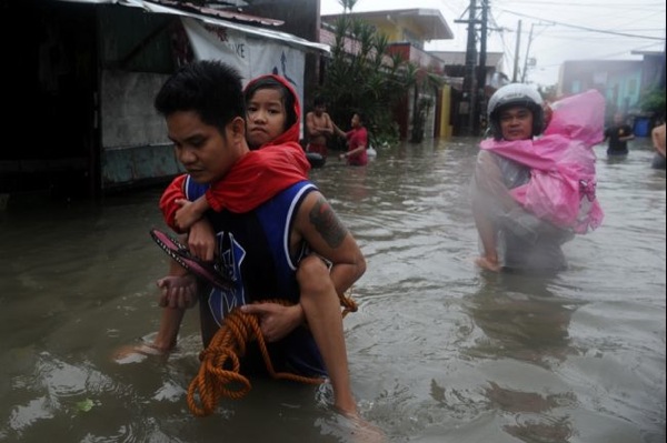
Flooding caused by some of the Philippines' heaviest rains on record submerged more than half the capital Tuesday, turning roads into rivers and trapping tens of thousands of people in homes and shelters. The government suspended all work except rescues and disaster response for a second day.

176912896

Throughout the sprawling, low-lying capital region of 12 million people, floodwaters made most of the roads impassable and reached waist- or neck-deep along rivers and creeks. Authorities opened more than 200 evacuation centers in Manila and surrounding provinces filled with tens of thousands of people, Social Welfare Secretary Corazon Soliman said. Overall, more than 600,000 people have been affected by the floods.

NewsBytes:

A tornado swept through a children's camp in Baden-Wurttemberg in Germany, injuring 27 child campers and staff.

Volcanos

Roundup of Global Volcanic Activity:

Popocatépetl (Central Mexico): Activity has not changed much and been relatively calm with 1-2 usually small emissions on average per hour. Glow remains visible at the summit. Accompanied by low-amplitude high frequency tremor, stronger ash emissions on 17 August occurred between 11:20 and 13:30(local time) and produced a plume of 1.5 km height, drifting WSW. Ash fall occurred in Tetela del volcán, Ocuituco, Yecapixtla, Tlayacapan, Cuautla, Ayala and Cuernavaca.

Fuego (Guatemala): A surge in effusive activity has occurred overnight. The two active lava flows towards the Taniluya (western flank) and Ceniza (southern flank) canyons increased to 600 and 800 m length, respectively. Numerous incandescent avalanches detach from the flow fronts and glowing blocks reach the vegetation limit.

Iliwerung (Lesser Sunda Islands): A submarine eruption has likely occurred this morning in Indonesia. VSI raised the alert level of Iliwerung volcano from 1 (normal) to 2 (watch) following increased seismic and visual activity from an underwater flank vent called Gunung Hobal. Iliwerung volcano forms a peninsula on the south coast of Lembata (Lomblen) Island (East Indonesia). Mount Hobal (Gunung Hobal) is a submarine flank vent of Iliwerung located about 800 m from the coast. It has had several historic eruptions during which several temporary islands were formed.

White Island (New Zealand): A small phreatic or hydrothermal eruption occurred at in the active crater earlier today (10:23 on Tuesday 20 August 2013 NZ local time). The explosion lasted for about 10 minutes and produced a steam plume mixed with small amounts of ash that rose about 4 km a.s.l. The activity at White Island has now returned to levels of high hydrothermal activity as before this morning's eruption.

Monday 19 August 2013

Earthquakes

Magnitude 5+ Earthquakes - Global

5.5 Earthquake hits Salta, Argentina.

5.3 Earthquake hits Mindanao in the Philippines.

5.2 Earthquake hits the Kermedec Islands, New Zealand.

5.0 Earthquake hits Halmahera, Indonesia.

5.0 Earthquake hits Fiji.

5.0 Earthquake hits the South Sandwich Islands.

Storms and Floods

Tropical Storms

In the Atlantic:

Post-tropical cyclone Erin has degenerated into a remnant low about 1080 mi (1740 km) WNW of the Cape Verde Islands.

In the Western Pacific:

Tropical storm Pewa is located approximately 769 nm east-southeastward of Wake Island.

Tropical storm Trami is located approximately 420 nm southward of Kadena Air Base, Japan. Trami is forecast to strike China at about 06:00 GMT on 22 August.

Tropical Storm Trami (Maring) has caused heavy rainfall and widespread flooding in Metro Manila and nearby provinces.

In the Central Pacific:

Tropical storm Unala is located about 1360 mi (2190 km) W of Honolulu, Hawaii.

NewsBytes:

Floods in Yobe state in Nigeria destroy more than 300 houses.

Worst flooding in three decades in Heilongjiang Province in China has claimed the lives of at least 11 people and left 3 others missing. Flooding has destroyed more than 1 million hectares of farmland and affected two million people.

Global Warming

European forests near 'carbon saturation point'

European forests are showing signs of reaching a saturation point as carbon sinks, a study has suggested. Since 2005, the amount of atmospheric CO2 absorbed by the continent's trees has been slowing. This was a result of a declining volume of trees, deforestation and the impact of natural disturbances.

Carbon sinks play a key role in the global carbon cycle and are promoted as a way to offset rising emissions. The carbon cycle is the process by which carbon - essential for life on the planet - is transferred between land (geosphere and terrestrial biosphere), sea (hydrosphere) and the atmosphere. Carbon sinks refers to the capacity of key components in the cycle - such as the soil, oceans, rock and fossil fuels - to store carbon, preventing it from being recycled, eg between the land and the atmosphere. Many of Europe's forests are reaching an age where growth, and carbon uptake, slows down.

The continent's forests had been recovering in recent times after centuries of stock decline and deforestation. The growth had also provided a "persistent carbon sink", which was projected to continue for decades.

However, the team's study observed three warnings that the carbon sink provided by Europe's tree stands was nearing a saturation point.

First, the stem volume increment rate (of individual trees) is increasing and thus the sink is curbing after decades of increase. Second, land use is intensifying, thereby leading to deforestation and associated carbon losses. Third, natural disturbances (like wildfires) are increasing and, as a consequence, so are the emissions of CO2.

53356577 forestfinlandbbc

Wildfires

Wildfires - Idaho - USA

Firefighters step up battle against Idaho blaze

On Sunday, firefighters mounted an all-out ground and air attack on an Idaho wildfire that has forced the evacuation of some 2,250 homes and threatened the world-class ski resort of Sun Valley, where snow-making water cannons were used to keep the flames at bay.

The fire raging across parched sagebrush, grasslands and pine forests near high-end developments in the Sun Valley area has consumed 101,000 acres and destroyed one home and seven other buildings since lightning sparked the blaze on August 7. More than 1,000 firefighters were engaged in what fire officials called "a heavy air show" and ground assault in a drive to gain the upper hand over a blaze stoked by dry, hot weather and strong, gusting winds.

Volcanos

Roundup of Global Volcanic Activity:

Sakurajima volcano (Japan): large explosion sends ash plume to 20,000 ft (6 km) altitude

A very large vulcanian explosion, one of the largest during this year occurred yesterday morning. It produced a mushroom shaped ash column that rose to about 20,000 ft (6 km) altitude that drifted over the Kagoshima.

People in Kagoshima city were seen wearing masks and raincoats and using umbrellas to protect themselves from the volcanic ash.

Sakurajima volcano eruption 2013 photo

Sunday 18 August 2013

Earthquakes

Magnitude 5+ Earthquakes - Global

6.3 Earthquake hits the southwest Indian ridge.

5.3 Earthquake hits Juyjuy, Argentina.

5.0 Earthquake hits south of the Aleutian Islands.

5.0 Earthquake hits the Rat Islands in the Aleutian Islands.

Storms and Floods

Tropical Storms

In the Atlantic:

Tropical depression Erin is located about 955 mi (1535 km) WNW of the Cape Verde Islands. Erin has weakened to a depression again. Erin weakened to a tropical depression, then regenerated into a tropical storm Friday as it continued westward over the open waters of the eastern Atlantic Ocean.

In the Western Pacific:

Tropical depression Twelve is located approximately 373 nm southward of Kadena Air Base, Japan.

Tropical depression Thirteen is located approximately 109 nm northwestward of Kadena Air Base, Japan. The final advisory has been issued on this system.

In the Central Pacific:

Tropical storm Pewa is located about about 1065 mi (1715 km) ESE of Wake Island. Pewa could become a typhoon in the next day or two.

Far Eastern Russia Floods

More than 17,000 people have been evacuated in Russia's flood-hit far east as floodwaters wreak havoc across the region. The deluge has been declared a natural disaster in the worst-affected regions of Amur and Khabarovsk, where the Russian President called on the army to participate in rescue operations. He promised that all damaged infrastructure would be repaired, and that while the situation was difficult it was "under control".

"Large areas are flooded, telephone and electricity lines, roads and bridges have been damaged in dozens of towns. The damage is enormous." Temporary shelters have been opened up, mostly in schools, to shelter evacuated residents. In the worst-case scenario up to 100,000 people could be evacuated. Massive rains since the end of July saw the Amur River - the longest in Siberia which borders northeastern China - burst its banks, as well as one of its tributaries the Zeya. Devastating floods last July in the town of Krymsk in the south west killed 172 people and raised questions about the authorities' handling of disasters.

Landslides in China

Several landslides caused by downpours brought by Typhoon Utor have claimed the lives of at least four people and left 13 others missing in China.

Landslide around 1:50 a.m. at the village of Hongshan in Cangwu County claimed the life of one person. Another landslide around 3:50 a.m. in Sifeng in the same county of Guangxi Zhuang Autonomous Region claimed the lives of two people.

Third landslide in Hunan Province claimed the life of one person and buried 13 others.

NewsBytes:

Wedding party of 76 swept away in floods in Yeman. At least 27 members of a Yemeni wedding party have died after the vehicles they were travelling in were swept away by heavy floods. The victims, including women and children, were travelling through Wadi Nakhla in Taiz province, in the south of the Arab country. The bride survived the incident. Several other people have been killed by flash floods in Yemen over the past two days.

Disease

Outbreak of Crimean-Congo Hemorrhagic Fever - Uganda

Uganda’s ministry of health on Friday confirmed the outbreak of the deadly Crimean-Congo hemorrhagic fever in the northern Uganda district of Agago.

According to the World Health Organisation (WHO), the Crimean-Congo hemorrhagic fever causes severe fever outbreaks and has a fatality rate of up to 40%.

WHO says the disease is transmitted to humans from ticks and from human to human through coming into contact with blood, secretions and body fluids from affected persons.

The disease has no vaccine available for either humans or animals.

Initial reports in Uganda had said it was the deadly Ebola outbreak but this has been ruled out by health officials.

In the last decade Uganda has reported two outbreaks of the deadly Ebola disease. In 2000, the disease killed 224 people in northern Uganda. More recently in 2012, it killed 17 people in western Uganda.

Wildfires

Wildfires sweep through the Portuguese island of Madeira.

Volcanos

Roundup of Global Volcanic Activity:

Kverkfjöll (Eastern Iceland): A small phreatic eruption seems to have taken place yesterday at the ice-covered Kverkfjoell central volcano. The steam-driven (no fresh magma involved) explosion followed a small glacial flood on 15 August the Kverkjökull glacier released into the Volga river and was probably a result of the pressure release during the flood.

Kliuchevskoi (Kamchatka): A new eruption began at 06:30 UTC on 15 August, KVERT reports. Accompanied by strong tremor, strombolian activity has been taking place in the summit crater. Incandescence at the summit of the volcano's summit were observed at night and a gas-steam plume containing small amounts of ash rose up to 18,000 ft (5.5 km) a.s.l. and drifted to the north-east of the volcano on August 16. Satellite data showed a big and bright thermal anomaly over the volcano on August 15-17. (KVERT weekly update)

Shiveluch (Kamchatka): Eruptive activity continued all week with explosions producing ash plumes that rose up to 16,400-22,960 ft (5.0-7.0 km) a.s.l. and extended to the east and north-east of the volcano. A viscous lava dome continues to extrude on the north-western flank of the lava dome, accompanied by strong and moderate degassing, incandescence, and hot avalanches.

Reventador (Ecuador): Eruptive activity continues at moderate levels. There are occasional ash explosions with plumes of a few 100 m height and possibly minor lava effusion from the intra-caldera cone at the summit.

Saturday 17 August 2013

Earthquakes

Magnitude 5+ Earthquakes - Global

5.4 Earthquake hits Guerrero, Mexico.

5.2 Earthquake hits Sulawesi, Indonesia.

5.2 Earthquake hits near the north coast of Papua, Indonesia.

5.2 Earthquake hits Atacama, Chile.

5.2 Earthquake hits the Cook Strait, New Zealand.

5.1 Earthquake hits the Cook Strait, New Zealand.

5.1 Earthquake hits northern Sumatra, Indonesia.

5.1 Earthquake hits the Bali Sea.

5.0 Earthquake hits Tonga.

5.0 Earthquake hits the Cook Strait, New Zealand.

A second 5.0 Earthquake hits the Cook Strait, New Zealand.

5.0 Earthquake hits the Rat islands in the Aleutian Islands.

A second 5.0 Earthquake hits the Rat islands in the Aleutian Islands.

Storms and Floods

Tropical Storms

In the Atlantic Ocean:

Tropical Storm Erin weakened into a tropical depression Friday as it moved west across the Atlantic from Africa. The storm is the fifth to receive a name in the Atlantic hurricane season.

As of 1500 GMT Friday, it was 870 kilometres (540 miles) west of the Cape Verde islands.

In the Pacific Ocean:

The Central Pacific Hurricane Centre is tracking three systems located in the Central Pacific.

The strongest is Tropical Storm Pewa, which was located 1275 miles SW of Kauaʻi at around 8 a.m. on Friday, Aug. 16, 2013, according to the CPHC. TS Pewa was last tracked moving WNW at 13 mph, and had maximum sustained winds of 40 mph, according to a CPHC forecast.

Forecasters say Pewa is the first tropical cyclone to develop within the Central North Pacific Basin in the 2013 season.

Floods close Trans-Siberian railway

Russian Railways on Thursday closed a section of the legendary Trans-Siberian railway because if serious flooding, potentially delaying a train en route from Moscow to the far eastern city of Vladivostok.

Flood water washed away some of the stone ballast supporting the track in the far eastern Amur region after a nearby river reached a “critical level”, Russian Railways said in a statement on its website.

Repair workers were propping up the affected area with concrete slabs and adding more crushed stones after the track was closed at a distance of around 7,500 kilometres (4,700 miles) from the capital. The repairs were expected to cause delays to the Moscow-Vladivostok passenger train, the railway monopoly said. The train left Moscow on Wednesday evening and was due to arrive in Vladivostok almost a week later.

Extreme flooding in the region has seen the emergency ministry evacuate more than 13,000 people from their homes. The Trans-Siberian railway, known as the Transsib in Russian, is the most reliable means of transport across the country, which is still not fully connected by modern motorways. The route betweeen Moscow and Vladivostok covers 9,300 kilometres (5,800 miles).

NewsBytes:

A sandstorm mixed with heavy rain hit the Wilayat of Mahout in the Governorate of Al Wusta, Oman. Local flooding also hit Wilayat in Al Mudhaibi.

Torrential rain ad thunderstorms in Bermuda have caused flooding and wide spread power outages. More than 1,300 homes in Southampton and Warwick are without power due to lightning strikes. According to the Bermuda Weather Service, a temperature of 21.6 C has been recorded which is the lowest since records began.

More flooding is expected in Sudan, the country's chief weather forecaster warned on Thursday, after severe rains have killed 53 people and affected about 200,000.

Environment

Unprecedented Summertime Heat Scorches Japan and China

Japan experienced its hottest temperature on record with a reading of 105.8 degrees Fahrenheit in Shimanto, a coastal city on the western island of Shikoku, according to the Japan Meteorological Agency.

That broke the previous record of 105.6 degrees set in August 2007.

A week of sweltering conditions sent almost 10,000 people to hospitals by ambulance across Japan, suffering from heat-related problems. Officials said at least 19 people died of heatstroke.

Air conditioning use strained the country’s power grids since Japan shut down its nuclear reactors in the wake of the tsunami-related Fukushima nuclear disaster two years ago.

Meanwhile, nearby China has experienced its hottest summer since 1961, according to the country’s National Meteorological Centre.

The official Xinhua news agency reports extreme heat since July 1 has resulted in at least 40 deaths in southern China, while more than 10 people died from heatstroke to the north in the financial hub of Shanghai alone during the period.

Authorities have for the first time declared the heat to be a second-level weather emergency, a designation normally reserved for typhoons and floods.

The World Meteorological Organization says that heat is the greatest killer of all weather phenomena, but it can take weeks after cooler weather returns to collect a full tally of heat-related fatalities.

Volcanos

Roundup of Global Volcanic Activity:

Karymsky (Kamchatka): An explosion probably occurred last night (inferred from seismic data), and might have produced an ash plume of up to 20,000 ft (7.5 km) elevation, Tokyo VAAC reported.

Batu Tara (Sunda Islands, Indonesia): Strombolian activity, sometimes strong, continues. A plume rose to 5,000 ft (1.5 km) altitude and drifted 70 nautical miles to the west earlier today (VAAC Darwin).

Veniaminof (Alaska Peninsula, USA): The eruption continues with lava effusion from the intracaldera cone, accompanied by strong tremor, AVO reports.

Pacaya (Guatemala): Another paroxysm with strong strombolian explosions and a lava flow occurred last night from the Mackenney crater. Starting at about 19:15 (local time), eruptive activity increased accompanied by volcanic tremor. Strombolian explosions ejected bombs and blocks to a height of 500 m above the crater and showered the outer flanks. VAAC Washington issued a bulletin but was unable to identify the height of the ash plume from satellite data. Ash fall was reported from nearby villages such as El Rodeo and El Patrocinio. At the height of the eruption, a lava flow issued from the west flank and reached a distance of 500 m.

Copahue (Chile/Argentina): Incandescence was observed last night from the crater. SERNAGEOMIN has not commented on possible renewed activity or changes at the volcano, but maintains alert level yellow. Since early July, seismic and degassing activity had decreased and the last eruptive activity noted was weak ash emission on 6 July.

Wildfires

Wildfires USA

The Idaho wildfires have forced the evacuation of 1,600 homes. Evacuation orders have been issued for the 100-square-mile Beaver Creek Fire including west of the towns of Hailey and Ketchum in central Idaho.

More than 600 state and federal firefighters are struggling to control the Idaho wildfires.

Firefighters and aircraft responded to several new fire starts in the Superior and Ninemile Ranger districts near Missoula, Montana.

Lightning sparked two wildfires in Arizona this week which are being fueled by dry brush and grass as temperatures remain between 105 and 110 degrees.

Disease

Somalia Polio Outbreak Spreads

Somalia is suffering an ‘‘explosive’’ outbreak of polio and now has more cases than the rest of the world combined, an official said Friday.

Vaccine-wielding health workers face a daunting challenge: accessing areas of Somalia controlled by al-Qaida-linked militants, where 7 of 10 children aren’t fully immunized.

Polio is mostly considered eliminated globally except mainly in three countries where it is considered endemic: Afghanistan, Nigeria and Pakistan. India marked a major success in February 2012 by being removed from the World Health Organization’s list of countries plagued by the disease.

Somalia now has 105 cases, figures released Friday show, and another 10 cases have been confirmed across the border in a Kenyan refugee camp filled with Somalis. Globally there have been 181 cases of polio this year, including those in Somalia and Kenya.

Friday 16 August 2013

Earthquakes

Magnitude 5+ Earthquakes - Global

6.8 Earthquake hits the Cook Strait, New Zealand.

No tsunami was generated and there were no reports of major damage to buildings in Wellington, but police said some houses had been damaged in Seddon near where the quake was centered.

644278 681651791863381 1193333297 n

5.9 Earthquake hits the Cook Strait, New Zealand.

5.7 Earthquake hits the Cook Strait, New Zealand.

5.6 Earthquake hits Chitinshaya Oblast', Russia.

5.5 Earthquake hits the Cook Strait, New Zealand.

5.4 Earthquake hits South Island, New Zealand.

5.2 Earthquake hits the Cook Strait, New Zealand.

5.1 Earthquake hits the Cook Strait, New Zealand.

5.0 Earthquake hits the Cook Strait, New Zealand.

5.0 Earthquake hits New Britain, Papua New Guinea.

5.0 Earthquake hits Sulawesi, Indonesia.

Unusual 4.2 Earthquake hits Sicily with numerous aftershocks.

Storms and Floods

Tropical Storms

In the Atlantic Ocean:

Tropical storm Erin forms in the eastern Atlantic and is located about 340 mi. (550 km) W of the Cape Verde Islands.

995179 681323301896230 865527892 n

Nature - Images

Interesting Images:

Full Moon in Greece:

1150420 681327325229161 969329064 n

Waterspout tornado and rainbow over the Baltic Sea:

64504 681331778562049 2142921980 n

Environment

Global Temperature Extremes

The week's hottest temperature was 117.0 degrees Fahrenheit (47.2 degrees Celsius) at Death Valley, California, USA.

The week's coldest temperature was minus 80.1 degrees Fahrenheit (minus 62.3 degrees Celsius) at Russia's Vostok Antarctic research station.

Temperatures were tabulated from the more than 10,000 worldwide synoptic weather stations. The United Nations World Meteorological Organization sets the standards for weather observations, and provides a global telecommunications circuit for data distribution.

Drought

Drought USA

A year ago, drought conditions stretched from coast to coast — Massachusetts to California — hitting central Georgia and the central Great Plains states of Kansas, Nebraska, Colorado, Oklahoma and Texas the hardest. Drought conditions in the Great Plains were worse than the driest summers of the Dust Bowl of the 1930s. By the end of July 2012, drought-related losses there were already estimated at $14 billion.

Today, the Great Plains are still suffering even with recent rains, and the drought has situated itself roughly along the nation’s traditional boundary between wet and dry — the 100th Meridian. East of that line, annual precipitation is generally above 25 inches; west of it, an arid climate reigns in most areas.

West of that line, the drought remains entrenched. East of that line, the drought has generally disappeared in most areas, though some parts of the Midwest and Texas are still drier than normal and moderate drought is surging again in Iowa.

Climate change may be partly responsible for how the drought is easing in some areas to the East, even as it's likely causing drought events to become frequent and severe.

Abnormally heavy summer rains have forced a partial retreat of exceptional drought, the term for the most devastating dry conditions, in Colorado, Kansas and other parts of the Great Plains, and a complete disappearance of all drought conditions in hard-hit Georgia, according to the August 13 edition of the Drought Monitor, published Thursday.

As of Thursday, the area of the country under moderate-to-exceptional drought conditions had fallen to 45.26 percent.

A year ago, exceptional drought conditions affected 6.26 percent of the contiguous U.S., concentrated mainly in Kansas, Nebraska, Oklahoma, Colorado, Arkansas, Missouri and Georgia.

Today, 2.03 percent of the country is suffering from the worst drought conditions, mainly in northwestern Kansas and the New Mexico’s central Rio Grande Valley, with some areas in northeast Arizona, western Nevada and eastern Colorado’s Arkansas River Valley.

8 15 13 Bobby DryCropsTexas2013 500x335