Wednesday, 30 September 2015

Earthquakes

Magnitude 5+ Earthquakes – Global

5.5 Earthquake hits Halmahera, Indonesia.

5.4 Earthquake hits New Britain, Papua New Guinea.

5.2 Earthquake hits southwestern Siberia, Russia.

5.1 Earthquake hits Taiwan.

5.1 Earthquake hits Guerrero, Mexico.

5.1 Earthquake hits the Molucca Sea.

5.0 Earthquake hits the Banda Sea.

5.0 Earthquake hits Vanuatu.

5.0 Earthquake hits Barbados in the Windward Islands.

5.0 Earthquake hits the Bismarck sea.

5.0 Earthquake hits Pakistan.

5.0 Earthquake hits Halmahera, Indonesia.

5.0 earthquake hits the Bougainville region, Papua New Guinea.

Storms and Floods

Tropical Storms - Roundup of Tropical Storms:

Tropical Storm Joaquin is located about 240 mi...390 km ENE of the central Bahamas with maximum sustained winds...70 mph...110 km/h. Present movement...WSW or 245 degrees at 6 mph...9 km/h.

Tropical Depression Marty is located about 115 mi...185 km SSW of Zihuatanejo Mexico and about 250 mi...405 km se of Manzanillo Mexico with maximum sustained winds...35 mph...55 km/h. Present movement...W or 270 degrees at 5 mph...7 km/h.

Invest 99L is an area of disturbed weather in the North Atlantic that has the potential for tropical development.

Invest 90L is an area of disturbed weather in the North Atlantic that has the potential for tropical development.

NewsBytes:

Florida, USA - High tide hit parts of South Florida Tuesday leaving some streets inundated with water. The super moon event brought exceptionally high tides to much of Florida’s coast causing sporadic flooding in many areas.

Wales - Rare 'supertides' have hit the Welsh coast, leading to a flood warning and seven flood alerts.

Wildlife

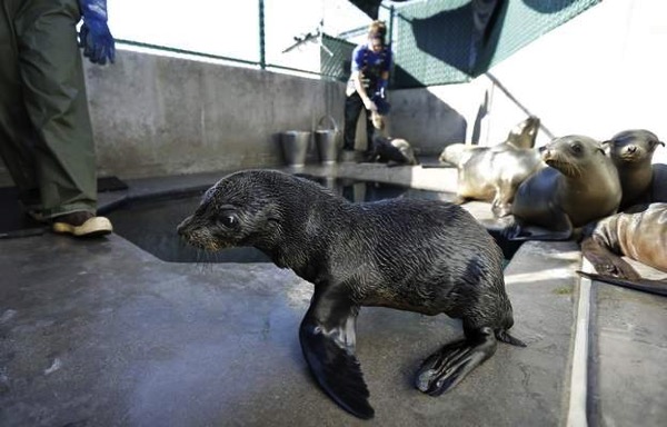
Spike in Fur Seals Dying Off California Coast

Scientists are looking at ocean-warming trends to figure out why endangered Guadalupe fur seals are stranding themselves and dying in alarming numbers along the central California coast.

Approximately 80 emaciated fur seals have come ashore since January — about eight times more than normal — leading the National Oceanic and Atmospheric Administration this week to declare an “unusual mortality event” for the animals. The classification diverts additional resources to study the animals, which have been traditionally under-researched, officials said.

Researchers will try to determine if the die-off is a result of a disruption in the seal’s feeding patterns from a large-scale warming of the Pacific Ocean, Toby Garfield, an official with NOAA’s Southwest Fisheries Science Centre, said Tuesday.

The so-called warm blobs occurring during a persistent high-pressure ridge have grown to cover most of the West Coast and have been previously blamed for discoveries of emaciated young sea lions off California and starving seabirds off Oregon and Washington.

Some of the fish species that fur seals usually eat may have moved farther north to escape the unusually warm waters, Garfield said during a teleconference.

AR 150929398 jpg maxh=400 maxw=667

Environment

New Zealand creates an ocean sanctuary twice its size

New Zealand is creating one of the world's largest fully protected ocean sanctuaries, twice the size of the nation itself, the country's prime minister announced on Monday.

"This is an area twice the size of our land mass and 50 times the size of our largest national park. It is truly a special place and we want to keep it that way," prime minister John Key said at a United Nations summit on Monday.

The 620,000 square kilometre (about 240,000 square miles) ocean sanctuary is in the Kermadec region, to the northeast of New Zealand.

The area is 35 times larger than the country's existing marine reserves and includes the world's longest chain of submerged volcanoes and the second deepest ocean trench, the New Zealand government said.

It's also home to several endangered sea turtle species, and serves as an important breeding and feeding ground for seabirds, whales and dolphins.

150930132619 new zealand kermedac ocean sanctuary exlarge 169

Wildfires

Wildfires - Indonesia - Smoke Pollution

Indonesia has sent nearly 21,000 personnel to fight forest fires raging in its northern islands, the disaster management agency said on Tuesday, but smoke cloaks much of the region with pollution readings in the “very unhealthy” region in neighbouring Singapore.

Slash-and-burn agriculture has blanketed Singapore, Malaysia and northern Indonesia in a choking “haze” for weeks, pushing up pollution levels and disrupting flights, as it does every year. Indonesia’s efforts to halt the seasonal clearances have failed.

More than 135,000 Indonesians were reported to be suffering from respiratory diseases, the disaster agency said in a statement.

Schools in parts of Malaysia were ordered closed for a second day on Tuesday and Singaporean commuters were wearing masks as they have for much of the last two weeks.

Indonesia has faced criticism for turning down offers of help from Singapore, even as it struggles to contain fires that have been exacerbated by a prolonged dry season.

Air quality index site AQICN.org's real-time map for Indonesia and surrounding jurisdictions for Sept. 29 at about 7 p.m. CT. The site categorizes readings between 201 to 300 as "very unhealthy" and greater than 300 as "hazardous." (AQICN.org)

Aqicn indonesiasept29 1000

Tuesday, 29 September 2015

Earthquakes

Magnitude 5+ Earthquakes – Global

5.4 Earthquake hits Jujuy, Argentina.

5.2 Earthquake hits south of the Kermedec Islands.

5.1 Earthquake hits offshore Honduras.

5.0 Earthquake hits off the east coast of Honshu, Japan.

Storms and Floods

Tropical Storms - Roundup of Tropical Storms:

Gl sst mm

Tropical Storm Joaquin is located about 385 mi...620 km NE of the central Bahamas with maximum sustained winds...40 mph...65 km/h. Present movement...W or 270 degrees at 5 mph...7 km/h.

Tropical Storm Marty is located about 95 mi...155 km S of Zihuatanejo Mexico and about 120 mi...195 km WSW of Acapulco Mexico with maximum sustained winds...65 mph...100 km/h. Present movement...E or 90 degrees at 2 mph...4 km/h.

Typhoon Dujuan is located approximately 131 nm west of Taipei, Taiwan, and is tracking northwestward at 11 knots.

Typhoon Dujuan has killed two people and left more than 300 injured in Taiwan, authorities said on Tuesday after it swept across the island before making landfall in eastern China. Almost half a million people are still without electricity in Taiwan as the storm left a trail of destruction in the north of the island. It hit the Chinese coastal city of Putian on Tuesday morning, but there were no immediate reports of damage.

Post-Tropical Cyclone Niala is located about 405 mi...650 km S of Honolulu Hawaii and about 315 mi...510 km SW of South Point Hawaii with maximum sustained winds...30 mph...45 km/h. Present movement...WNW or 285 degrees at 9 mph...15 km/h.

Invest 99L is an area of disturbed weather in the North Atlantic that has the potential for tropical development.

NewsBytes:

USA - Historic rainfall along the Gulf Coast turned roads into canals and parking lots into lakes — and no letup was expected Monday. Mobile, Alabama, saw its 10th wettest day since records began in 1871, according to Weather Channel lead meteorologist Kevin Roth. The city was drenched by more than 7.5 inches of rain Sunday. The deluge was still going strong early Monday, also soaking areas of the Florida Panhandle, while a separate system of heavy rain was hitting parts of Louisiana and Texas. In Mississippi, some residents were forced to leave their cars in the garage — instead taking to canoes — after the torrent left streets underwater. The Magnolia State saw most of its rain Sunday and the system had largely moved on by Monday morning.

Disease

New Legionnaires’ Disease Outbreak in New York

New York City health officials are investigating seven cases of Legionnaires’ disease in the Bronx, about two months after an outbreak of the same type of pneumonia killed 12 people in the borough and sickened more than 100.

The new cluster is associated with the Morris Park section of the Bronx, and is unrelated to the earlier outbreak, which was centred in the South Bronx, city officials said Monday.

Hand, Foot and Mouth Disease in Jamaica

The Ministry of Education is reporting that there is now an outbreak of the hand, foot and mouth disease in several schools on the island.

Monday, 28 September 2015

Earthquakes

Magnitude 5+ Earthquakes – Global

5.3 Earthquake hits the northern Mid-Atlantic ridge.

5.2 Earthquake hits offshore Coquimbo, Chile.

5.1 Earthquake hits the northern Mid-Atlantic ridge.

5.1 Earthquake hits the northern Mid-Atlantic ridge.

5.0 Earthquake hits offshore Coquimbo, Chile.

5.0 Earthquake hits the northern Mid-Atlantic ridge.

5.0 Earthquake hits the northern Mid-Atlantic ridge.

Storms and Floods

Tropical Storms - Roundup of Tropical Storms:

Gl sst mm

Tropical Storm Marty is located about 170 mi...275 km SSW of Zihuatanejo Mexico and about 225 mi...360 km WSW of Acapulco Mexico with maximum sustained winds...70 mph...110 km/h. Present movement...N or 360 degrees at 2 mph...4 km/h.

Typhoon Dujuan is located approximately 101 nm southeast of Taipei, Taiwan, and is tracking northwestward at 10 knots.

Strong Typhoon Dujuan (Typhoon Jenny in Philippines) is forecast to bring torrential rains and high winds across Taiwan, with landfall predicted around 15:00 GMT Monday. Almost 3,000 people, most of them tourists, were evacuated Sunday from Taiwan's Green Island and Orchid Island.

Tropical Storm Niala is located about 330 mi...530 km SSW of Hilo Hawaii and about 440 mi...705 km SSE of Honolulu Hawaii with maximum sustained winds...40 mph...65 km/h. Present movement...WSW or 245 degrees at 10 mph...17 km/h.

Tropical Depression Eleven is located about 420 mi...675 km SW of Bermuda with maximum sustained winds...35 mph...55 km/h. Present movement...W or 275 degrees at 2 mph...4 km/h.

Invest 99L is an area of disturbed weather in the North Atlantic that has the potential for tropical development.

NewsBytes:

Mississippi, USA - A flash flood emergency has been declared until 8 p.m. Sunday for the eastern part of Jackson County, Mississippi, including Pascagoula, Moss Point and Escatawpa, the National Weather Service said. Doppler radar has noted five to eight inches rainfall in the area and another two inches are expected.

Disease

Middle East respiratory syndrome coronavirus (MERS-CoV) - Saudi Arabia

Between 12 and 18 September 2015, the National IHR Focal Point for the Kingdom of Saudi Arabia notified WHO of 13 additional cases of Middle East respiratory syndrome coronavirus (MERS-CoV) infection, including 1 death.

Cholera – Iraq

On 15 September 2015, WHO received a notification from the IHR National Focal Point of Iraq of laboratory-confirmation of cholera in at least five governorates.

As of 23 September 2015, a total of 120 stool samples have been tested positive at the Central Public Health Laboratory of Baghdad for Vibrio cholerae 01 Inaba. Laboratory-confirmed cases have so far been reported from at-least five Governorates of the country- Baghdad Babylon, Najaf, Qadisiyyah, and Muthanna. The preliminary investigation revealed contaminated water source as the cause of this current outbreak.

Sunday, 27 September 2015

Earthquakes

Magnitude 5+ Earthquakes – Global

5.6 Earthquake hits Kepulauan Babar, Indonesia.

5.3 Earthquake hits New Britain, Papua New Guinea.

5.2 Earthquake hits the Celebes Sea.

5.1 Earthquake hits the Chagos Archipelago.

5.1 Earthquake hits the Pacific-Antarctic ridge.

5.0 Earthquake hits Tonga.

5.0 Earthquake hits Hokkaido, Japan.

5.0 Earthquake hits the Gulf of California.

Wildlife

New Study Provides Graphic 'Tree of Life'

The first draft of what’s being called the “Tree of Life” shows how all of the planet’s 2.3 million named species of animals, plants, fungi and microbes are related.

Researchers from 11 separate institutions created the detailed family tree of all creatures great and small, which shows how life evolved and diverged.

While tens of thousands of smaller “trees” have been published for specific branches of nature, this is the first time they’ve been combined to give an organized structure to all living things.

Understanding how species are related can help scientists discover new drugs, increase crop and livestock yields, and trace the origins and spread of infectious diseases such as HIV, Ebola and influenza, the researchers say.

The tree can be seen here.

Ew150925a

Volcanos

Roundup of Global Volcanic Activity

Bagana (Bougainville Island, Papua New Guinea): Mild activity with occasional explosions seems to continue at the volcano. A volcanic ash plume to 7,000 ft (2.1 km) altitude was detected this morning extending 55 nautical miles to the NE (Darwin VAAC). A weak to moderate thermal anomaly has been recorded by MODIS satellite sensor over the past months.

Dukono (Halmahera): Strong, often near-continuous ash emissions continue at the volcano. Yesterday, VAAC Darwin reported an ash plume extending 70 km to the NE.

Telica (Nicaragua): A series of 5 moderately strong explosions occurred at the volcano yesterday and lasted half an hour. It produced dense ash plumes and ejected blocks to up to 500 m distance. According to Nicaraguan press, the activity is still phreatic and does not involve new magma, but it could be building up to a magmatic eruption. Authorities for the time being rule out evacuations, but have started to prepare for the case this would become necessary.

Saturday, 26 September 2015

Earthquakes

Magnitude 5+ Earthquakes – Global

6.6 Earthquake hits Coquimbo, Chile.

5.4 Earthquake hits the Loyalty Islands.

5.2 Earthquake hits offshore Coquimbo, Chile.

5.1 Earthquake hits the Anatahan region in the North Mariana Islands.

5.1 Earthquake hits Coquimbo, Chile.

5.0 Earthquake hits the Chagos Archipelago.

Storms and Floods

Tropical Storms - Roundup of Tropical Storms:

Gl sst mm

Tropical Depression Ida is located about 1155 mi...1855 km ENE of the northern Leeward Islands with maximum sustained winds...35 mph...55 km/h. Present movement...NW or 325 degrees at 8 mph...13 km/h.

Typhoon Dujuan is located approximately 323 nm south-southeast of Kadena AB, Japan and is tracking south-southeastward at 04 knots.

Tropical Storm Niala is located about 325 mi...525 km se of Hilo Hawaii and about 535 mi...865 km se of Honolulu Hawaii with maximum sustained winds...50 mph...85 km/h. Present movement...NW or 325 degrees at 8 mph...13 km/h.

Invest 92E is an area of disturbed weather in the East Pacific that has the potential for tropical development.

Invest 92E is an area of disturbed weather in the East Pacific that has the potential for tropical development.

Invest 98L is an area of disturbed weather in the North Atlantic that has the potential for tropical development.

NewsBytes:

Nigeria - Floods in Nigeria destroyed rice plantations that produce about 11 percent of what Africa’s biggest economy needs to meet this year’s consumption. Above-normal rainfall in the country’s northwest region caused the banks of the Sokoto and Rima rivers to overflow in the Sokoto and Zamfara states, flooding rice plantations and destroying about 626,250 metric tons of the staple. In the Kebbi and Jigawa states, a combined 635,000 hectares of low-land, rain-fed plantations have been affected. About 350,000 hectares of rice plantations spread across 12 local government areas in the state are totally submerged in flood water across Kebbi alone.

Drought

Drought in Malawi

More than 2.8 million people will face hunger in the coming months in the worst food crisis in a decade in Malawi, where a staggering four out of every 10 children suffer from stunting, the United Nations World Food Programme (WFP) warned today.

"People in some affected districts have already started selling their livestock to make ends meet," WFP said in a press release. "Women are also engaging in more firewood and charcoal selling, which degrades the environment and further aggravates the fragile climate."

"The agency said more than 2.8 million people will face hunger in the coming months following severe floods and drought that ruined this year's harvest.

"The floods early this year were the worst in living memory in Malawi, washing away homes and food stocks, and ruining fertile land," it said. "Some crops managed to withstand the floods only to succumb to intense dry spells in the following months, making survival even more difficult for the most vulnerable."

Wildfires

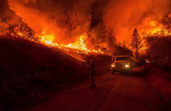
Wildfires - California, USA - Update

The Valley Fire in Lake County has killed four people, destroyed more than 2 000 structures -- many of those are homes -- and charred more than 76,067 acres. It is 87 percent contained as of Friday morning and has caused hundreds of millions of dollars in damage.

In Calaveras and Amador counties, the Butte Fire has destroyed 70,868 acres and 820 structures. The wildfire, which is 93 percent contained, is responsible for two deaths.

Cal Fire spokesman Daniel Berlant said both fires will likely be controlled by "early next week."

Friday, 25 September 2015

Earthquakes

Magnitude 5+ Earthquakes – Global

6.7 Earthquake hits near the north coast of Papua, Indonesia.

Hundreds of people fled their homes in panic in Sorong and at least 39 people were hurt, mostly with broken bones. Nearly 260 houses and buildings were damaged. Hundreds of people were evacuated to temporary shelters as authorities surveyed the damage.

6.0 Earthquake hits the Solomon Islands.

5.5 Earthquake hits Vancouver Island, Canada.

5.3 Earthquake hits Tarapaca, Chile.

5.2 Earthquake hits southeast of Easter Island.

5.1 Earthquake hits Coquimbo, Chile.

Two 5.1 Earthquakes hit south of the Kermedec islands.

5.1 Earthquake hits the Kuril Islands.

Storms and Floods

Tropical Storms - Roundup of Tropical Storms:

Tropical Depression Ida is located about 1180 mi...1900 km ENE of the northern Leeward Islands with maximum sustained winds...35 mph...55 km/h. Present movement...NNW or 335 degrees at 3 mph...6 km/h.

Typhoon Dujuan is located approximately 485 nm south-southeast of Kadena AB, Japan and is tracking west-northwestward at 04 knots.

Tropical Depression Six-C is located about 490 mi...790 km se of Hilo Hawaii and about 700 mi...1125 km se of Honolulu Hawaii with maximum sustained winds...35 mph...55 km/h. Present movement...NW or 315 degrees at 7 mph...11 km/h

Invest 92E is an area of disturbed weather in the East Pacific that has the potential for tropical development.

Gl sst mm

Global Warming

Melting Arctic Ice Causing More Methane Emissions

The melting of the Arctic ice cap is encouraging more natural emissions of methane — one of the most potent greenhouse gases driving climate change.

Researchers at Sweden’s Lund University worked with Dutch and American colleagues to find that the recent accelerated melt of sea ice around the North Pole is allowing the Arctic’s surface waters to absorb more heat and promote the growth of microorganisms in the adjacent tundra.

Those microbes in turn give off natural methane emissions that promote even further climate change and sea ice loss.

This feedback loop of warming and melting appears to have increased with virtually every new cycle over the past decade.

“While numerous studies have shown the effects of sea ice loss on the ocean, there are only a few that show how this oceanic change affects ecosystems on the surrounding land," said study author Frans-Jan Parmentier.

The findings were published in the journal Geophysical Research Letters.

Microbes in recently thawed Arctic tundra are emitting the powerful greenhouse gas methane because of the greater summertime melt of the polar ice cap.

Ew150925c

Wildlife

Giraffes Found to Hum at Night

It seems that giraffes are not as voiceless as previously thought, and have been observed humming in the night as a possible form of communication when their vision is limited.

Many wildlife experts have thought the animals’ necks are too long for them to be able to vocalize.

But analysis of sound recordings of giraffe habitats at three European zoos revealed the stately animals occasionally emit a low-frequency sound at about 92 hertz — barely within the range of human hearing.

“I was fascinated because these signals have a very interesting sound and have a complex acoustic structure,” said University of Vienna researcher Angela Stöger, who identified the giraffes as the sources of the hums.

But since she wasn’t able to see the animals at the time of the sounds, she doesn’t know if they were even awake, or what might have been the motivation for the sounds.

Ew150925g

Environment

Global Temperature Extremes

The week's hottest temperature was 117.3 degrees Fahrenheit (47.4 degrees Celsius) at Mecca, Saudi Arabia.

The week's coldest temperature was minus 102.6 degrees Fahrenheit (minus 47.8 degrees Celsius) at Russia's Vostok Antarctic research station.

Temperatures were tabulated from the more than 10,000 worldwide synoptic weather stations. The United Nations World Meteorological Organization sets the standards for weather observations, and provides a global telecommunications circuit for data distribution.

Volcanos

Roundup of Global Volcanic Activity

Telica (Nicaragua): New explosions with ash emissions occurred at the volcano during the past days, following a period of calm that had lasted several months since the series of similar eruptions earlier this year in May.

The first explosions started on Tuesday 23 Aug from around 08:00 local time and produced ash plumes that rose to approx. 500 m height. Ash fell in up to 30 km distance west of the volcano in the department of Chinandega. Another similar phase of activity occurred yesterday starting at 13:43.

Volcanologists from INETER assume that the activity is phreatic, ie. not caused by fresh magma near the surface.

Thursday, 24 September 2015

Earthquakes

Magnitude 5+ Earthquakes – Global

5.2 Earthquake hits North Island, New Zealand.

5.1 Earthquake hits southwest of Sumatra, Indonesia.

Storms and Floods

Tropical Storms - Roundup of Tropical Storms:

Tropical Storm Ida is located about 1155 mi...1855 km E of the northern Leeward Islands with maximum sustained winds...40 mph...65 km/h. Present movement...E or 90 degrees at 6 mph...9 km/h.

Tropical Storm Dujuan is located approximately 541 nm south-southeast of Kadena AB, Japan and is tracking west-southwestward at 04 knots.

Invest 96C is an area of disturbed weather in the Central Pacific that has the potential for tropical development.

Invest 92E is an area of disturbed weather in the East Pacific that has the potential for tropical development.

NewsBytes:

229409

Turkey - A massive amount of rain late on Tuesday caused flash floods in Turkey's tourist resort town of Bodrum, inundating the area with so much water that cars were floating in the streets. The three-hour downpour was so intense that flash floods quickly enveloped many streets in Bodrum, an Aegean resort town in Muğla province, causing significant physical damage as the tourist season comes to a close.

Malaysia - Several areas in Penang were inundated by flash floods and mudflow after more than five hours of rain since 4am yesterday morning.

Global Warming

When and where global warming first appeared

The indications of climate change are all around us today but now researchers have revealed for the first time when and where the first clear signs of global warming appeared in the temperature record and where those signals are likely to be clearly seen in extreme rainfall events in the near future.

The research shows that one could already see clear signs of global warming in the tropics by the 1960s but in parts of Australia, South East Asia and Africa it was visible as early as the 1940s.

The reason the first changes in average temperature and temperature extremes appeared in the tropics was because those regions generally experienced a much narrower range of temperatures. This meant smaller shifts in the temperature record due to global warming were more easily seen.

The first signal to appear in the tropics was the change in average temperatures. Later extreme temperature events showed a global warming signal.

Closer to the poles the emergence of climate change in the temperature record appeared later but by the period 1980-2000 the temperature record in most regions of the world were showing clear global warming signals.

Disease

Middle East respiratory syndrome coronavirus (MERS-CoV) – Kuwait

On 19 September 2015, the National IHR Focal Point of Kuwait notified WHO of 1 additional fatal case of Middle East respiratory syndrome coronavirus (MERS-CoV) infection.

Wednesday, 23 September 2015

Earthquakes

Magnitude 5+ Earthquakes – Global

5.1 Earthquake hits Kyrgyzstan.

5.0 Earthquake hits offshore Coquimbo, Chile.

5.0 Earthquake hits Seram, Indonesia.

Storms and Floods

Tropical Storms - Roundup of Tropical Storms:

Gl sst mm

Tropical Storm Ida is located about 1045 mi...1685 km E of the northern Leeward Islands with maximum sustained winds...40 mph...65 km/h. Present movement...S or 180 degrees at 2 mph...4 km/h.

Tropical Storm Dujuan is located approximately 655 nm southeast of Kadena AB, Japan and is tracking west-northwestward at 12 knots.

Invest 96C is an area of disturbed weather in the Central Pacific that has the potential for tropical development.

Invest 97L is an area of disturbed weather in the North Atlantic that has the potential for tropical development.

NewsBytes:

Vietnam - Floods caused by torrential rains over the past few days killed four people in the central province of Nghe An.

Disease

Cholera in Iraq

A suburb of Baghdad is currently experiencing a wave of cholera, triggered by increasingly poor hygiene and depleted resources as the Iraqi government struggles to expand its control over territories coveted by the Islamic State terrorist group.

The Parliamentary Health and Environment Committee of Iraq announced on Sunday that they had confirmed 41 cases of cholera in Iraq–most in or near Baghdad, and in Najaf and Babel provinces. At least four of those diagnosed had died at the time of the announcement. Some close to the outbreak suggest that the number might be much greater, however. Voice of America cites sources reporting at least 100 cases of the disease. Vice notes that a number of medical groups claim upwards of 300 cases of cholera so far. Many of these are symptomatic patients whose diagnosis has not been confirmed yet.

Volcanos

Roundup of Global Volcanic Activity

Piton de la Fournaise (La Réunion): The eruption continues into its second month,- for Piton de La Fournaise's standards this is an unusually long-lived one. Accompanied by stable tremor, effusive activity remains strong and feeds a growing lava flow field that slowly expands towards the east in direction of the Grandes Pentes. At the site of the main vent near Piton Rivals, a cone with a small lava lake has formed. From there, the lava flows for a large part of its path through lava tubes that then feed several flow branches further downslope. Occasionally, when parts of the tube system becomes blocked or unstable, new surface flows develop near the vent, such as last night when a new surface flow appeared that began flowing to the southeast.

Tuesday, 22 September 2015

Earthquakes

Magnitude 5+ Earthquakes – Global

6.5 Earthquake hits Coquimbo, Chile.

6.1 Earthquake hits Coquimbo, Chile.

5.8 Earthquake hits offshore Coquimbo, Chile.

5.7 Earthquake hits offshore Coquimbo, Chile.

5.4 Earthquake hits Vanuatu.

5.3 Earthquake hits offshore Coquimbo, Chile.

5.1 Earthquake hits Tonga.

5.1 Earthquake hits offshore Coquimbo, Chile.

5.1 Earthquake hits the Gulf of Aden.

5.0 Earthquake hits New Britain, Papua New Guinea.

5.0 Earthquake hits Papua, Indonesia.

Storms and Floods

Tropical Storms - Roundup of Tropical Storms:

Gl sst mm

Tropical Storm Malia is located about 250 mi...400 km NW of Maro Reef and about 165 mi...265 km NNE of Lisianski Island with maximum sustained winds...40 mph...65 km/h. Present movement...NNW or 340 degrees at 8 mph...13 km/h.

Tropical Storm Ida is located about 965 mi...1555 km ENE of the northern Leeward Islands with maximum sustained winds...45 mph...75 km/h. Present movement...ESE or 105 degrees at 5 mph...7 km/h.

Tropical Depression Twenty-One is located approximately 910 nm southeast of Kadena AB, Japan and is tracking northwestward at 09 knots.

Invest 96C is an area of disturbed weather in the Central Pacific that has the potential for tropical development.

Invest 97L is an area of disturbed weather in the North Atlantic that has the potential for tropical development.

NewsBytes:

Nigeria - At least 2,000 houses in some parts of Kaduna State, Northwest Nigeria, have been submerged by flood as a result of a heavy rainfall. The flood was said to have been caused by an unusual heavy downpour that lasted for over 48 hours. The rainfall which started on Saturday night till Monday morning, caused massive floods at Abubakar Kigo road new extension, Barnawa, Ungwar-Rimi, Gonin-Gora, Karatudu, Kachia, Romi among others. More than 30, 000 people had been forced out of their homes following the incident.

Wildfires

Wildfires - California, USA - Update

California fire officials said Sunday the wildfire north of San Francisco destroyed another 162 homes, raising the number of homes destroyed to 1,050 and making it the fourth worst wildfire in the state’s history.

The tally brought the total number of homes destroyed in two wildfires burning in Northern California the past two weeks to nearly 1,600, the California Department of Forestry and Fire Protection said. Those fires killed five people, and on Sunday authorities announced that a body was found near the source of a new wildfire in Monterey County that destroyed or damaged 10 homes.

Farther north, the two massive wildfires (Valley and Butte wildfires) continue to threaten at least 6 500 more homes.

Disease

Mad cow disease reported in Slovenia

A case of Bovine spongiform encephalopathy (BSE), or mad cow disease was confirmed in a 12-year-old cow, which died on a farm in Adlešiči, in southeastern Slovenia, according to the World Organisation of Animal Health (OIE).

Testing by the National Veterinary Institute (National laboratory) were positive for BSE via rapid tests and Western Blot. The animal will be killed and safely disposed of.

Monday, 21 September 2015

Earthquakes

Magnitude 5+ Earthquakes – Global

6.2 Earthquake hits offshore Coquimbo, Chile.

5.2 Earthquake hits Coquimbo, Chile.

5.0 Earthquake hits west of MacQuarie Island.

Storms and Floods

Tropical Storms - Roundup of Tropical Storms:

Tropical Storm Malia is located about 200 mi...320 km ESE of Lisianski Island and about 60 mi...95 km SW of Maro Reef with maximum sustained winds...40 mph...65 km/h. Present movement...NNE or 25 degrees at 12 mph...19 km/h.

Tropical Storm Ida is located about 1035 mi...1670 km E of the northern Leeward Islands with maximum sustained winds...50 mph...85 km/h. Present movement...NNW or 330 degrees at 8 mph...13 km/h.

Tropical Depression Sixteen-E is located about 35 mi...60 km NW of Santa Rosalia Mexico with maximum sustained winds...35 mph...55 km/h, Present movement...NNE or 15 degrees at 17 mph...28 km/h.

Invest 96C is an area of disturbed weather in the Central Pacific that has the potential for tropical development.

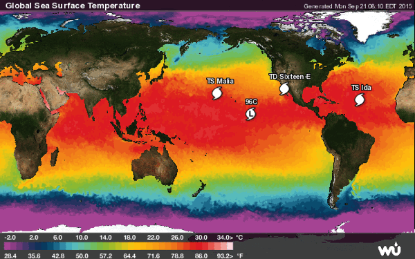
Gl sst mm

Volcanos

Roundup of Global Volcanic Activity

Sinabung (Sumatra, Indonesia): Several pyroclastic flows, some relatively large, have occurred over the past days. While the slow effusive activity itself has not significantly changes, the lava dome and its viscous lava lobes that spilled over onto the steep upper flanks are now undergoing a phase of increased collapses due to increased instability.

Nevado del Ruiz (Colombia): The internal and external activity of the volcano has increased during the past two weeks. Several pulses of tremor were accompanied by ash emissions that produced plumes that rose up to 1.5 2.5 km above the crater, last on 17 and 19 Sep. As fall occurred in areas west of the volcano including Pereira, Dosquebradas, Santa Rosa, Chinchiná, Villamaría, and Manizales. Weak incandescence, probably due to hot gasses, has been noted from the Arenas crater at night since early Sep. A small explosion on 4 Sep produced incandescent ejecta. At the moment, it is unclear whether fresh magma has been involved in the recent activity or whether it is phreatic in origin, i.e. caused by overheated water circulating in the volcano's upper hydrothermal system.

Cotopaxi (Ecuador): The volcano remains active at low to moderate levels (seismicity and emissions). It continues to produce mild ash emissions that usually drift westwards and rise approx. 1 km from the crater. The government continues to train local people from potentially endangered zones, responsible for small groups, to be prepared and react in case of emergency. Measures include lectures on contingency planning on family level, emergency kits and evacuation route maps.

Meru (Tanzania): A new eruption has been reported yesterday from the volcano, which has last been active 105 years ago. An ash plume was seen rising approx. 1 km and drifting NW from what looks like a lateral vent on the northern slope of the volcano near Arusha town. The are no reports of damage or fatalities. According to local sources, people in the area around the volcano have been experiencing an increased number of small felt earthquakes in recent months.

Sunday, 20 September 2015

Earthquakes

Magnitude 5+ Earthquakes – Global

5.9 Earthquake hits offshore Valparaiso, Chile.

5.4 Earthquake hits Coquimbo, Chile.

5.1 Earthquake hits Coquimbo, Chile.

5.5 Earthquake hits offshore Coquimbo, Chile.

5.3 Earthquake hits offshore Coquimbo, Chile.

5.3 Earthquake hits offshore Coquimbo, Chile.

5.0 Earthquake hits offshore Coquimbo, Chile.

Storms and Floods

Tropical Storms - Roundup of Tropical Storms:

Typhoon Krovanh is located approximately 562 nm southeast of Misawa, Japan, and is tracking northeastward at 15 knots.

Tropical Storm Ida is located about 1300 mi...2090 km W of the Cape Verde Islands with maximum sustained winds...40 mph...65 km/h. Present movement...WNW or 295 degrees at 15 mph...24 km/h.

Tropical Depression Five-C is located about 395 mi...635 km S of Lisianski Island and about 395 mi...635 km NW of Johnston Island with maximum sustained winds...35 mph...55 km/h. Present movement...NNE or 15 degrees at 9 mph...15 km/h.

Invest 96L is an area of disturbed weather in the North Atlantic that has the potential for tropical development.

Invest 91E is an area of disturbed weather in the East Pacific that has the potential for tropical development.

NewsBytes:

Iran - Flash floods triggered by heavy rains have killed 10 people in the capital, Tehran, and south of the country. At least eight people, including five members of the same family in Tehran, were still missing. Relief and rescue operations are underway. Authorities attribute the rising number of deadly flash floods to deforestation and improper construction near riverbeds.

Wildfires

Wildfires - California, USA

Screen Shot 2015 09 20 at 1 40 23 PM

The two California wildfires prompting Gov. Jerry Brown to declare a state of emergency last week are still raging. Together, they have killed five people and destroyed more than 1,100 homes, according to multiple reports.

According to the California Department of Forestry and Fire Protection, aka Cal Fire, the so-called Butte Fire, spread out across Calaveras and Amador counties, burned 70,760 acres, destroyed 503 homes and killed two people between its beginning 10 days ago and Saturday morning, when it was 65 percent contained. A Cal Fire representative, Lynette Round, said the fire’s two fatalities rejected orders to evacuate their homes.

A separate blaze, the so-called Valley Fire, centered in southern Lake County, scorched 74,500 acres, destroyed 585 homes and killed three people between its start seven days ago and Saturday morning, when it was 48 percent contained, Cal Fire reported. According to the Associated Press, it is unclear whether those who perished in the Valley Fire received evacuation notices, but two of the three declined requests by friends and relatives to vacate their residences.

Buttefirejoshedelsonafpgetty

Disease

Disease Outbreak in Cape Town Prison - South Africa

Nearly 5,000 Pollsmoor Prison inmates are being moved to other prisons in the Western Cape following an outbreak of a highly infectious disease that has killed two prisoners.

The inmates died two weeks ago from a disease carried by rodents. It's believed a rat infestation at the facility is to blame for the outbreak.

Earlier this month, Constitutional Court Judge Edwin Cameron released a damning report about what he called inhumane conditions at the prison.

The Department of Correctional Services' Simphiwe Xako said, “We are to contain the outbreak of leptospirosis and we are moving the offenders to various facilities around the province.” The evacuation is expected to take six to eight weeks.

Saturday, 19 September 2015

Earthquakes

Magnitude 5+ Earthquakes – Global

6.1 Earthquake hits Coquimbo, Chile.

5.8 Earthquake hits offshore Atacama, Chile.

5.3 Earthquake hits offshore Coquimbo, Chile.

5.3 Earthquake hits offshore Coquimbo, Chile.

5.3 Earthquake hits offshore Coquimbo, Chile.

5.2 Earthquake hits offshore Coquimbo, Chile.

5.2 Earthquake hits offshore Coquimbo, Chile.

5.1 Earthquake hits offshore Coquimbo, Chile.

5.0 Earthquake hits offshore Coquimbo, Chile.

5.0 Earthquake hits offshore Coquimbo, Chile.

5.0 Earthquake hits offshore Coquimbo, Chile.

5.6 Earthquake hits the northern Mid-Atlantic ridge.

5.4 Earthquake hits the northern Mid-Atlantic ridge.

5.2 Earthquake hits New Britain, Papua New Guinea.

5.2 Earthquake hits southeast of the Loyalty Islands.

5.1 Earthquake hits New Britain, Papua New Guinea.

5.0 Earthquake hits Kepulauan Talaud, Indonesia.

5.0 Earthquake hits Papua, Indonesia.

Storms and Floods

Tropical Storms - Roundup of Tropical Storms:

Typhoon Krovanh is located approximately 444 nm south-southeast of Yokosuka, Japan, and is tracking northeastward at 15 knots.

Tropical Storm Ida is located about 970 mi...1565 km W of the Cape Verde Islands with maximum sustained winds...40 mph...65 km/h. Present movement...NW or 305 degrees at 10 mph...17 km/h.

Tropical Depression Nine is located about 815 mi...1310 km ENE of the Lesser Antilles with maximum sustained winds...30 mph...45 km/h. Present movement...WNW or 290 degrees at 12 mph...19 km/h.

Tropical Depression Five-C is located about 525 mi...845 km S of Lisianski Island and about 510 mi...825 km SSW of Maro Reef with maximum sustained winds...35 mph...55 km/h. Present movement...NNE or 30 degrees at 9 mph...15 km/h.

Invest 96L is an area of disturbed weather in the North Atlantic that has the potential for tropical development.

Invest 91E is an area of disturbed weather in the East Pacific that has the potential for tropical development.

Gl sst mm

Disease

Middle East Respiratory Syndrome coronavirus (MERS-CoV) – Jordan

Between 7 and 10 August 2015, the National IHR Focal Point of Jordan notified WHO of 5 additional cases of Middle East respiratory syndrome coronavirus (MERS-CoV) infection, including 2 deaths.

West Nile virus – Portugal

On 14 September 2015, the National IHR Focal Point for Portugal notified WHO of a confirmed human case of West Nile virus (WNV) infection. The patient is a 71-year-old male from the town of Almancil (Loulé municipality) – Algarve Region, Portugal with no recent history of travel. On 20 July, he was hospitalized with neurological symptoms.

Dengue Fever in Taiwan

The number of dengue fever cases in Tainan since the start of summer recorded a daily increase of 523, bringing the total to 10,157, a record high for the municipality in southern Taiwan, the city's department of health said Friday.

Tainan is by far the worst-hit area of the country, with only two of the city's 37 districts remaining free of the mosquito-borne disease. Its southern neighbour, Kaohsiung, has seen 1,277 cases.

Friday, 18 September 2015

Earthquakes

Magnitude 5+ Earthquakes – Global

Central Chile was rocked Wednesday evening by an 8.3 magnitude quake that killed at least fifteen people, injured dozens of others and caused widespread damage from its shaking and subsequent tsunamis.

Large waves surged into coastal towns minutes after the initial temblor struck 140 miles north of Santiago at 7:54 p.m. local time.

Strong aftershocks roiled the Pacific and caused further shaking onshore for hours following what was one of the world’s strongest earthquakes so far this year.

The largest tsunami was 16 feet in height and caused significant damage when it swamped the downtown area of Coquimbo.

While a Pacific-wide tsunami alert was issued following the first quake, there were only minor fluctuations in sea level reported as far away as New Zealand.

In 2010, an 8.8-magnitude earthquake in central-southern Chile triggered a massive tsunami and left more than 500 people dead from the ocean surge and shaking onshore.

Tahiti tsunami warning map

6.3 Earthquake hits offshore Valparaiso, Chile.

5.7 Earthquake hits offshore Valparaiso, Chile.

5.3 Earthquake hits offshore Valparaiso, Chile.

5.1 Earthquake hits offshore Valparaiso, Chile.

5.6 Earthquake hits offshore Coquimbo, Chile.

5.6 Earthquake hits offshore Coquimbo, Chile.

5.4 Earthquake hits offshore Coquimbo, Chile.

5.4 Earthquake hits offshore Coquimbo, Chile.

5.3 Earthquake hits offshore Coquimbo, Chile.

5.2 Earthquake hits offshore Coquimbo, Chile.

5.6 Earthquake hits offshore Coquimbo, Chile.

5.2 Earthquake hits offshore Coquimbo, Chile.

5.0 Earthquake hits offshore Coquimbo, Chile.

5.0 Earthquake hits offshore Coquimbo, Chile.

5.0 Earthquake hits offshore Coquimbo, Chile.

7.0 Earthquake hits Coquimbo, Chile.

5.0 Earthquake hits Coquimbo, Chile.

5.0 Earthquake hits Hokkaido, Japan.

5.0 Earthquake hits New Britain, Papua New Guinea.

Storms and Floods

Tropical Storms - Roundup of Tropical Storms:

Typhoon Krovanh is located approximately 55 nm east of Iwo To, and is tracking northward at 12 knots.

Tropical Depression Nine is located about 1045 mi...1680 km E of the Lesser Antilles with maximum sustained winds...30 mph...45 km/h. Present movement...NNW or 330 degrees at 7 mph...11 km/h.

Invest 95L is an area of disturbed weather in the North Atlantic that has the potential for tropical development.

Invest 95C is an area of disturbed weather in the Central Pacific that has the potential for tropical development.

NewsBytes:

Sierra Leone - At least nine people were killed and thousands made homeless in severe floods Thursday as Freetown, Sierra Leone was buffeted by torrential rains.

Utah, USA - Update - The death toll in the floods that hit Utah this week has risen to 18.

Global Warming

Global Warming Disrupting Arctic Life for the Caribou

Earth’s climate has changed constantly during the 4 billion years that life has lived on this planet. But usually, it changes slowly. When the climate has changed quickly, species that failed to adapt died off, often in shocking numbers. The quickly warming Arctic is now forcing caribou to adapt.

The caribou breeding cycle is timed to the sun, not to temperature. It is timed so that baby caribou will be born during late May or early June, every year, without exception. Plants are different. They time their growth cycle to the temperature. They can be awakened early.

Before the Arctic started warming, these two cycles were in sync. A pregnant caribou could count on there being plenty of nutrient-rich vegetation around in May, when she needed it most, to feed the single baby calf growing within her.

Climate change is decoupling these cycles. Plants are erupting out of the ground earlier in the year. By the time pregnant caribou arrive at their birthing grounds, the vegetation has already peaked. Mothers are becoming malnourished. Fewer calves are being born, and fewer are surviving their crucial first few months. And even when they do survive, they are still vulnerable, to overhunting, and to diseases carried north by deer that would never have survived the Arctic chill of yesteryear.

Caribou populations are reeling. And now they face a new menace - Mosquitoes.

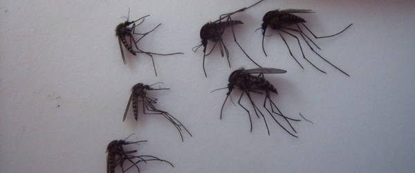
The Arctic mosquito, a larger, furrier version of the ubiquitous pests, are getting a longer breeding season as Arctic ponds warmed earlier in the year, researchers from Dartmouth have found.

The large flying insects are a nuisance to humans but potentially harmful to wildlife, especially caribou. While they're not known to spread disease, the persistent insects can drive the caribou to remote snowbanks or hilltops to seek shelter. They will go to the top of windy hill. When they do that, they are often moving to areas with no food or no quality food.

The earlier the insects hatch, the bigger a problem they become for the caribou since they overlap with the birth of caribou calves, researchers said, noting that if the calves are forced to retreat to snowier or more desolate areas, they could die without adequate nutrition. In the Arctic, temperatures have increased at twice the global rate in the past 100 years, according to the study.

Increased mosquito abundance, in addition to northward range expansions of additional pest species, will have negative consequences for the health and reproduction of the caribou.

Ht mosquitos 1 kab 150917 12x5 1600

Environment

Global Temperature Extremes

The week's hottest temperature was 118.0 degrees Fahrenheit (47.8 degrees Celsius) at Death Valley, California, USA.

The week's coldest temperature was minus 103.2 degrees Fahrenheit (minus 75.1 degrees Celsius) at the U.S. Amundsen–Scott South Pole Station.

Temperatures were tabulated from the more than 10,000 worldwide synoptic weather stations. The United Nations World Meteorological Organization sets the standards for weather observations, and provides a global telecommunications circuit for data distribution.

Disease

Middle East Respiratory Syndrome coronavirus (MERS-CoV) – Saudi Arabia

Between 6 and 11 September 2015, the National IHR Focal Point for the Kingdom of Saudi Arabia notified WHO of 22 additional cases of Middle East respiratory syndrome coronavirus (MERS-CoV) infection. Three (3) of these reported cases are associated with a MERS-CoV outbreak currently occurring in a hospital in Riyadh city. Five (5) of these reported cases are associated with another MERS-CoV outbreak occurring in a hospital in Madinah city.

Chikungunya – Spain (update)

On 3 August 2015, WHO was notified by the National IHR Focal Point for Spain of a case of chikungunya infection in the city of Gandia, Valencian Community. The patient, a 60-year-old man, had no history of travel outside the European Region.

Cholera in Nigerian Camp

The National Emergency Management Agency (NEMA) has confirmed the outbreak of cholera in one of the internally displaced persons camp in Borno state.

The disease outbreak started in a camp in Sanda Kyarimi in Borno state. Nine people have been killed from the disease outbreak. A total of 96 others – already treated and mostly discharged – were affected.

Volcanos

Roundup of Global Volcanic Activity

Mauna Loa (Big Island, Hawai'i): The alert level of the world's largest volcano was raised a notch to "ADVISORY", and the Aviation Color code to "YELLOW" becuase shallow earthquakes have recently appeared in increasing numbers under the volcano. There is no sign that the volcano is about to erupt in a very near future, but it could be a medium- or long-term precursor of a next eruption. The last eruption of Manua Loa occurred in 1984.

Thursday, 17 September 2015

Earthquakes

Magnitude 5+ Earthquakes – Global

7.9 (Initial 8.3) Earthquake hits offshore Coquimbo, Chile.

Thousands of residents of this small city in northern Chile were sleeping outside Thursday after a powerful earthquake destroyed their homes, a tremor that also forced more than 1 million to evacuate and killed eight people in the quake-prone South American nation.

Several coastal towns were flooded from small tsunami waves set off by the late Wednesday quake, which shook the Earth so strongly that rumbles were felt across South America.

The magnitude-8.3 quake that hit off northern Chile on Wednesday night lasted for three minutes, causing buildings to sway in the capital, Santiago, and prompting authorities to issue a tsunami warning for the Andean nation’s entire Pacific coast. People sought safety in the streets of inland cities, while others along the shore took to their cars to race to higher ground.

Tsunami advisories were in effect for Hawaii and parts of California. Tsunami warnings in Chile were lifted early Thursday.

The tremor was so strong that people in Buenos Aires, Argentina, on the other side of the continent, felt it. People in Peru and Brazil also reported feeling the shakes. No injuries were reported outside of Chile.

6.3 Earthquake hits offshore Coquimbo, Chile.

6.2 Earthquake hits offshore Coquimbo, Chile.

6.1 Earthquake hits offshore Coquimbo, Chile.

5.8 Earthquake hits offshore Coquimbo, Chile.

5.7 Earthquake hits offshore Coquimbo, Chile.

5.2 Earthquake hits offshore Coquimbo, Chile.

5.6 Earthquake hits offshore Coquimbo, Chile.

5.2 Earthquake hits offshore Coquimbo, Chile.

5.0 Earthquake hits offshore Coquimbo, Chile.

6.3 Earthquake hits offshore Coquimbo, Chile.

5.3 Earthquake hits offshore Coquimbo, Chile.

5.5 Earthquake hits offshore Coquimbo, Chile.

5.2 Earthquake hits offshore Coquimbo, Chile.

5.1 Earthquake hits offshore Coquimbo, Chile.

5.7 Earthquake hits offshore Coquimbo, Chile.

5.2 Earthquake hits offshore Coquimbo, Chile.

5.1 Earthquake hits offshore Coquimbo, Chile.

5.0 Earthquake hits offshore Coquimbo, Chile.

5.0 Earthquake hits offshore Coquimbo, Chile.

7.0 Earthquake hits Coquimbo, Chile.

5.0 Earthquake hits Coquimbo, Chile.

5.1 Earthquake hits Coquimbo, Chile.

6.2 Earthquake hits Coquimbo, Chile.

5.4 Earthquake hits Coquimbo, Chile.

5.9 Earthquake hits Coquimbo, Chile.

5.2 Earthquake hits Coquimbo, Chile.

6.4 Earthquake hits Coquimbo, Chile.

5.1 Earthquake hits Coquimbo, Chile.

5.0 Earthquake hits Coquimbo, Chile.

5.5 Earthquake hits Coquimbo, Chile.

5.9 Earthquake hits New Britain, Papua New Guinea.

5.5 Earthquake hits Taiwan.

5.0 Earthquake hits the Kermedec Islands.

5.3 Earthquake hits New Britain, Papua New Guinea.

5.1 Earthquake hits offshore Tarapaca, Chile.

5.1 Earthquake hits New Britain, Papua New Guinea.

5.0 Earthquake hits the Dodecanese Islands, Greece.

6.5 Earthquake hits Maranhao, Brazil.

5.6 Earthquake hits San Luis, Argentina.

5.2 Earthquake hits New Britain, Papua New Guinea.

5.4 Earthquake hits near the east coast of Kamchatka, Russia.
Storms and Floods

Tropical Storms - Roundup of Tropical Storms:

Typhoon Krovanh is located approximately 245 nm southeast of Iwo To, and is tracking northwestward at 07 knots.

Tropical Depression Nine is located about 1065 mi...1715 km E of the Lesser Antilles and about 1410 mi...2275 km W of the Cape Verde Islands with maximum sustained winds...35 mph...55 km/h. Present movement...NW or 325 degrees at 7 mph...11 km/h.

Invest 95L is an area of disturbed weather in the North Atlantic that has the potential for tropical development.

Invest 95C is an area of disturbed weather in the Central Pacific that has the potential for tropical development.

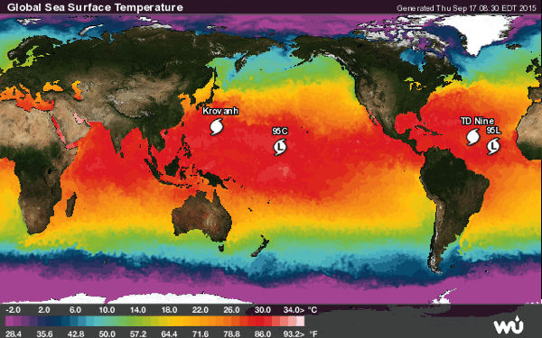
Gl sst mm

Disease

Tuberculosis Outbreak at British School

Nearly 200 people have tested positive for a tuberculosis infection following an outbreak at a school in Devon.

Public Health England, which released the results on Wednesday of screening that took place over the summer term at Teign school.

Many of those who tested positive are receiving treatment for latent TB infection to prevent the development of the disease in the future. Health authorities stressed they do not have the disease and are not infectious.

Wildfires

Wildfires - California, USA

A second fatality was confirmed on Wednesday in the massive California wildfires that have also destroyed more than 800 homes and forced the evacuation of 20,000 people, but crews appeared to turn a corner against the blazes as rain fell over the region.

The so-called Valley and Butte fires are the two most destructive blazes in an intense wildfire season in California that is already shaping up as one of the fiercest on record with much of September and October - historically the worst two months of the year - still ahead.

The more ferocious of the two latest blazes, the so-called Valley Fire, erupted on Saturday and raced through several communities north of Napa County's wine-producing region, destroying 585 homes and hundreds of other structures.

But a cooling trend, higher moisture levels and diminished winds have helped firefighters gain ground against the blaze in recent days, according to officials from the California Department of Forestry and Fire Protection (Cal Fire).

Sporadic drizzle fell Wednesday over the county seat of Lakeport, site of the fire command post.

Containment of the fire - a measure of how much of its perimeter has been enclosed within buffer lines carved through vegetation by ground crews - had grown to 30 percent by Wednesday morning, Cal Fire said.

Volcanos

Roundup of Global Volcanic Activity

Karangetang (Siau Island, Sangihe Islands, Indonesia): An eruptive event yesterday produced an ash plume that rose from what could be a new lateral vent on the lower northern flank of the volcano. Although the photo sent to us looks rather like an ash plume that originated from the front of an avalanche that departed at low level, local sources insist on having observed a new vent.

Wednesday, 16 September 2015

Earthquakes

Magnitude 5+ Earthquakes – Global

6.2 Earthquake hits the Molucca Sea.

5.6 Earthquake hits Taiwan.

5.1 Earthquake hits offshore Tarapaca, Chile.

5.1 Earthquake hits the southern east Pacific rise.

5.0 Earthquake hits offshore Tarapaca, Chile.

5.0 Earthquake hits the Kashmir-Xinjiang border.

Storms and Floods

Tropical Storms - Roundup of Tropical Storms:

Gl sst mm

Tropical Storm Krovanh is located approximately 391 nm north-northeast of Andersen AFB, and is tracking west-northwestward at 13 knots.

Invest 93L is an area of disturbed weather in the North Atlantic that has the potential for tropical development.

Invest 95L is an area of disturbed weather in the North Atlantic that has the potential for tropical development.

Invest 95C is an area of disturbed weather in the Central Pacific that has the potential for tropical development.

NewsBytes:

Utah, USA - Update - Flash floods in Hildale, Utah have claimed the lives of at least sixteen people and left four others missing. According to Reuters, flash floods near Utah's border with Arizona killed 12 people and left one missing. Similarly, four people died and three went missing in Zion National Park to the north, after going to explore canyons.

Wildlife

Marine life in oceans has almost halved

Marine mammal, birds, fish and reptile populations have almost halved since 1970, according to a report which is a “wake-up call” to tackle the crisis in the world’s oceans.

The study by conservation group WWF and the Zoological Society of London looked at how 5,829 populations of 1,234 species of marine creatures had fared in the past 45 years and found a 49 per cent drop in numbers in the face of over-fishing and habitat loss. Some species people rely on for food are faring even worse, such as the Scombridae family of fish which includes tuna and mackerel have fallen by almost three quarters (74 per cent).

Sea cucumbers, which are prized as luxury food in Asia, have been significantly exploited, with a 98 per cent decline in the Galapagos and 94 per cent drop in the Egyptian Red Sea in just a few years.

Habitats are being affected by human activity, with an estimated loss of 29 per cent of seagrass area – important for food, stabilising the seabed and acting as a nursery for many species – since 1879, and mangrove cover down a fifth since 1980.

Climate change is also beginning to have an impact with carbon dioxide being absorbed into the oceans and making them more acidic which damages species with shells, warming seas are hitting corals and fish are having to shift their range.

Declines were most severe in the 1970s and 1980s, due to a “gold rush” as improved technology allowed increasing levels of fishing, and have largely stabilised since 1990, although there is evidence of new declines in the past few years, WWF said.

Despite declines slowing on a global level, experts warned populations were not at the levels they should be and were not recovering.

The conservationists said there were steps that governments and consumers could take to reverse the declining trend. Networks of marine protected areas, where some damaging activities such as destructive types of fishing are banned or limited, needed to be created, and implementing the soon-to-be-agreed Sustainable Development Goals, one of which focuses on the oceans, would hopefully have an impact.

Image

Global Warming

Arctic Sea Ice Annual Minimum

Arctic sea ice hit its annual minimum extent for the summer on Sept. 11, 2015. The ice covered 1.7 million square miles (4.41 million square kilometers), seen here superimposed on the 1981-2010 average, drawn as a gold line. 2015 represents the fourth lowest since satellite observations began.

Arctic sea ice minimum

Tuesday, 15 September 2015

Earthquakes

Magnitude 5+ Earthquakes – Global

5.0 Earthquake hits offshore Antofagasta, Chile.

5.0 Earthquake hits south of the Kermedec Islands.

5.0 Earthquake hits Fiji.

Storms and Floods

Tropical Storms - Roundup of Tropical Storms:

Gl sst mm

Tropical Depression Twenty is located approximately 366 nm east-northeast of Saipan, and is tracking northwestward at 10 knots.

Invest 90E is an area of disturbed weather in the East Pacific that has the potential for tropical development.

Invest 93L is an area of disturbed weather in the North Atlantic that has the potential for tropical development.

Invest 94L is an area of disturbed weather in the North Atlantic that has the potential for tropical development.

Invest 95L is an area of disturbed weather in the North Atlantic that has the potential for tropical development.

NewsBytes:

Mecca Grand Mosque Crane Collapse Lightning

Saudi Arabia - A crane collapse caused by a lightning storm at Mecca's Grand Mosque in Saudi Arabia has claimed the lives of at least 107 people and injured 238 others. A worker at the mosque told the AFP news agency that he saw the massive construction crane fall after being hit by the storm.

Utah, USA - State officials said seven people were killed and six others missing when two cars were washed away by a flash flood Monday.

Global Warming

Emaciated Polar Bear - Reality of Global Warming

11896034 1045109095501030 4991489562653432165 n

Wildlife photographer Kerstin Langenberger captured this shocking photo of a deathly thin and starving polar bear as it struggles to capture food in the melting icecaps. It shows the effects of climate change better than any explanation . . .

Global warming alert as El Niño returns with a vengeance

The world is starting to heat up again, say British scientists, raising speculation that a 15-year slowdown in the rate of global warming could be coming to an end.

A pause in the rate of global temperature rises since the late 1990s has baffled climate scientists and led some to question whether man-made climate change was a serious problem.

But last year was the warmest on record, according to the UN’s World Meteorological Organisation, and scientists at the UK’s Met Office say both this year and 2016 are shaping up to be just as hot.

The strengthening Pacific weather pattern, El Niño, which some US scientists forecast could be the most powerful in years, is likely to be one reason for the rise in temperatures.

California's 'Snow Drought'

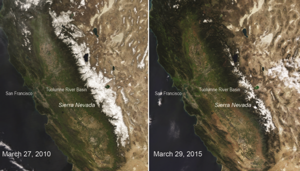
In April, statewide measurements of water contents of California’s snowpack -- a major source of water for reservoirs during the summers -- showed that the water content in the snow was only 5 percent of the normal for that date, making it the lowest in a 75-year record. Further analysis of available data has now shown that the situation is much worse than previously estimated.

According to a new study, published Monday in the journal Nature Climate Change, the amount of snow in the Sierra Nevada is now at its lowest level in over 500 years.

California snowpack

Disease

Chikungunya – Senegal

On 9 September 2015, the Ministry of Health and Social Affairs (MOHSA) of Senegal notified WHO of active circulation of chikungunya virus in the region of Kédougou. The circulation began on 27 August 2015. Samples were collected from 14 suspected cases for laboratory-confirmation at the Institut Pasteur of Dakar. Ten (10) samples tested positive for chikungunya virus. As of 8 September 2015, ten (10) chikungunya confirmed cases were reported. The latest active circulation in the affected area was reported between 2009 and 2010.

Poliovirus in Ukraine and Mali

The World Health Organization (WHO) recently confirmed the occurrence of two vaccine-derived polio cases in Ukraine and one case in Mali. The vaccine-derived polio cases are the ones caused by a mutant from the original wild poliovirus.

Although the number of reported cases of polio has significantly reduced globally, WHO believes that the incidence of three newly reported cases in Mali and Ukraine suggest why no country can be complacent about it and that every child should be immunized against the disease. Ukraine, on the other hand, has very low rates of polio immunization.

Bubonic Plague Case in USA

A Michigan resident recently contracted Bubonic plague after a visit to Colorado, health authorities confirmed Monday. The case is the first reported this year in the state and the 14th diagnosis nationwide.

The life-threatening disease is not native to Michigan and occurs when a person is bitten by an infected flea or rodent with the bacterium Yersinia pestis.

Infected populations often live in Western, rural areas of the country. Bubonic plague cannot travel from person to person.

Wildfires

Wildfires - California, USA

The catastrophic wildfires burning in California, which killed at least one person over the weekend and injured several others, are being fuelled by high temperatures, strong winds and years of withering drought influenced by climate change.

The Valley Fire ignited in drought-stricken Northern California early Saturday afternoon, destroying more than 400 homes and scorching 50,000 acres — an area more than twice the size of Manhattan — within about 12 hours.

The wildfires storming California have been four years in the making, as the drought, thought to be heavily influenced by climate change, has been starving California’s forests and mountains of water and snow, turning once-lush woods into crackling tinder that has ignited in explosive and unexpected ways.

The trend in wildfire destruction in California and throughout the West bends toward bigger, more destructive and drought-driven blazes. On average, wildfires burn six times the acreage they did 40 years ago, while the annual number of wildfires over 1,000 acres has doubled from 50 during an average year in the 1970s to more than 100 each year since 2002.

That scenario is playing out in California this week as just two of the state’s 13 most active and catastrophic wildfires — the Valley Fire and the Butte Fire — have burned more than 130,000 acres since Wednesday, leaving behind “mass destruction” and leading to numerous evacuations in the region.

Volcanos

Roundup of Global Volcanic Activity

Sinabung (Sumatra, Indonesia): A moderately large pyroclastic flow occurred this morning (08:22 local time) at the volcano. The associated ash plume rose to 18,000 ft (5.4 km) altitude. During the past months, Sinabung has continued to slowly extrude viscous lava that accumulates at its top in form of a dome with lobes on the upper slopes. When parts of these unstable features collapse, they generate such avalanches. Overall, activity at the volcano has been gradually decreasing recently.

Monday, 14 September 2015

Earthquakes

Magnitude 5+ Earthquakes – Global

5.3 Earthquake hits the Gulf of California.

5.1 Earthquake hits Fiji.

5.0 Earthquake hits the Gulf of California.

Storms and Floods

Tropical Storms - Roundup of Tropical Storms:

Gl sst mm

Tropical Storm Vamco is located approximately 86 nm east-southeast of Da Nang, Vietnam, and is tracking west-northwestward at 06 knots.

Invest 90E is an area of disturbed weather in the East Pacific that has the potential for tropical development.

Invest 93L is an area of disturbed weather in the North Atlantic that has the potential for tropical development.

Invest 94L is an area of disturbed weather in the North Atlantic that has the potential for tropical development.

NewsBytes:

Ireland - Floodwaters inundated homes and roads in western Ireland after heavy rains over the weekend. One man died after drowning in a car.

Disease

Hand, Foot and Mouth Disease in Japan - Advisory

The Centres for Disease Control and Prevention (CDC) updated their travel notice for Japan after the World Health Organization (WHO) updated the hand, foot and mouth disease (HFMD) case count to 264,541 cases through Aug. 19, 2015.

While cases have steadily increased since mid-March, health officials say the cases have been in decline during the past several weeks.

HFMD is typically a benign and self-limiting disease. Most common in young children, it presents as fever, oral lesions and rash on the hands, feet and buttocks. The oral lesions consist of rapidly-ulcerating vesicles on the buccal mucosa, tongue, palate and gums. The rash consists of papulovesicular lesions on the palms, fingers and soles, which generally persist for seven to 10 days, and maculopapular lesions on the buttocks.

Dengue Fever in India

Delhi is witnessing its biggest outbreak of dengue cases in five years. The strains of the disease that have emerged as the more dominant subtypes this year involve rapid drops in platelet levels, leading to a rush at clinics, hospitals and blood banks. Doctors believe the coming four weeks could see a rise in cases as the temperatures haven't dipped yet.

By September 5, 1259 cases of dengue had been recorded. This is the highest since 2009, when 1512 cases were recorded. The Delhi Health Department has issued an advisory to all hospitals not to refuse admission to any dengue patient. The hospitals have also been asked to increase the number of beds made available for the treatment of dengue patients.

Volcanos

Roundup of Global Volcanic Activity

Aso (Japan): Mount Aso, a volcano on the southern Japanese island of Kyushu, has erupted, sending huge plumes of black and then white smoke 2,000 metres into the air. The eruption Monday prompted authorities to raise the alert level for the area, banning people from approaching within 2 kilometres of the volcano's mouth. There are no homes within that area and there were no immediate reports of injuries or damage.

Sunday, 13 September 2015

Earthquakes

Magnitude 5+ Earthquakes – Global

6.6 Earthquake hits the Gulf of California.

5.8 Earthquake hits Minahasa, Sulawesi, Indonesia.

5.7 Earthquake hits south of the Kermedec Islands.

5.7 Earthquake hits the North Pacific Ocean.

5.5 Earthquake hits eastern New Guinea, Papua New Guinea.

5.5 Earthquake hits Hokkaido, Japan.

5.3 Earthquake hits the Gulf of California.

5.2 Earthquake hits south of Fiji.

5.1 Earthquake hits the Gulf of California.

5.1 Earthquake hits the Kermedec Islands.

5.0 Earthquake hits Sulawesi, Indonesia.

Storms and Floods

Tropical Storms - Roundup of Tropical Storms:

Gl sst mm

Invest 90E is an area of disturbed weather in the East Pacific that has the potential for tropical development.

NewsBytes:

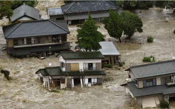
Japan — Update - Floods that swept houses off their foundations and crushed others under landslides spread across Japan on Friday as more rivers burst their banks, leaving at least 25 people missing and forcing more than 100,000 to flee. A severe rain warning remained in effect for parts of northern Japan but floodwaters were retreating in the city of Joso after toppling trees and washing houses away, sometimes with their owners still inside.

Global Warming

Climate change and Antarctica

A world-renowned climate scientist visiting New Zealand will this week present new evidence suggesting a behemoth "sleeping giant" ice sheet is more sensitive to climate change than we ever thought.

To climate scientists, the vast East Antarctic Ice Sheet represents something of the elephant in the room in terms of what it could contribute to global sea level rise.

If all of it melted, the ice sheet, which forms most of Antarctica, would contribute an equivalent of around 50 metres of sea level rise - the vast majority of the total 58 metres that could come from the frozen continent.

The part of the ice sheet that rests on bedrock below sea level is most vulnerable and holds an equivalent of 19 metres of sea level rise.

In the face of climate change, which has brought warmer ocean water to the edges of Antarctica, the vast ice sheet has been long regarded by scientists to be much more stable when compared with the smaller, 25 million square kilometre West Antarctic Ice Sheet, which satellite measurements estimated was losing more than 150 cubic kilometres of ice each year.

But an Australian expedition that managed to reach the typically inaccessible Totten Glacier in East Antarctica in January revealed some of the first direct evidence that warmer waters were having a significant impact there as well.

This means the wider ice sheet's contribution to future sea level rise could be much greater than realised.

500642791 620x310

Buryatia: where thawing permafrost is turning to steppe

Buryatia has been hit in summer 2015 by the massive destruction of its pristine forests in a series of fast-spreading fires. Most shocking have been the scenes showing uncontrolled burning around Lake Baikal, the oldest and deepest lake in the world, containing 20% of the globe's unfrozen freshwater.

Local scientists have accumulated startling evidence of the changes in temperature which are turning the region's permafrost - established over many millennia - into steppe. Average annual temperatures in a rising number of areas are exceeding zero degrees Celsius.

Warming caused the upper layer of permafrost to become deeper - and where it is thin, to disappear altogether. The average annual precipitation isn't changing, but it evaporates more easily which causes the climate to get drier. This results in changes in flora. It becomes more monotonous, dominated by drought-resistant plants.

As the climate becomes drier, the territory covered in forests and meadows reduces, while the dry steppe - arid grass plains with few trees - increases. Apart from that, there are changes in terms of the radial growth of trees. In dry lands, including Selenginskyi and Kyakhtinskyi districts, growth slows down.

Currently, some 55,000 hectares remain ablaze in Buryatia. In other regions, the figures are 46,000 hectares in Krasnoyarsk and 11,000 in Irkutsk.

Disease

Monkeypox Outbreak in DR Congo

At least 20 suspected monkeypox cases have been reported since the beginning of the week in Tshuapa district, Democratic Republic of the Congo.

Sources say that 18 of the suspect cases are hospitalized at a hospital in the town of Ikela. Despite not being laboratory confirmed, the Chief Health officer in the Mbamba health area, Dr Jean-Pierre Inonga said they are calling the cases monkeypox based of several telltale symptoms presented – fever, scabs and generalized skin rash .

The resurgence of the viral disease is believed to be due to consumption of game animals found dead in the forest by the public.

Monkeypox is a relatively rare disease caused by the virus with the same name, which is found primarily in central and western Africa. It is closely related to the smallpox virus (variola), the virus used in the smallpox vaccine (vaccinia), and the cowpox virus. Infection with monkeypox is not as serious as its cousin, smallpox; however, human deaths have been attributed to monkeypox.

Wildfires

Wildfires - California, USA

Thousands of people rushed to escape a massive wildfire charging across the tinder-dry Sierra Nevada foothills and another out-of-control fire that broke out in Northern California on Saturday, sending four firefighters to the hospital with second-degree burns.

The fire began in Lake County, about 100 miles north of San Francisco, and grew to about 15 square miles (or 10,000 acres) in just a few hours, the California Department of Forestry and Fire Protection said.

The fire forced the evacuation of two towns as well as residents along a 35-mile stretch of State Route 29.

Saturday, 12 September 2015

Earthquakes

Magnitude 5+ Earthquakes – Global

5.5 Earthquake hits near the east coast of Honshu, japan.

5.4 Earthquake hits eastern New Guinea, Papua New Guinea.

5.1 Earthquake hits eastern New Guinea, Papua New Guinea.

5.0 Earthquake hits off the coast of Chiapas, Mexico.

5.0 Earthquake hits eastern New Guinea, Papua New Guinea.

5.0 Earthquake hits Minahasa, Sulawesi, Indonesia.

5.0 Earthquake hits San Juan, Argentina.

5.0 Earthquake hits near the north coast of Papua, Indonesia.

Storms and Floods

Tropical Storms - Roundup of Tropical Storms:

Tropical Storm Kilo is located approximately 309 nm east-southeast of Misawa, Japan, and is tracking north-northwestward at 17 knots.

NewsBytes:

Japan - Japan advised almost 3 million people to evacuate after heavy flooding this week killed three people and left 16 people missing in the eastern region. At least 27 people have been injured across 10 prefectures since floods inundated parts of eastern Japan. Rescue teams in Osaki city battled to save residents Friday after a section of a levee containing the Shibui River broke.n some areas during the past two days, residents were forced to their rooftops, desperately awaiting rescue by military helicopters. The raging brown floodwaters spawned from Tropical Storm Etau, which has dumped more than 60 centimetres (2 feet) of rain over some areas since Monday.

Screen Shot 2015 09 12 at 12 40 56 PM

Texas, USA - One person died and another remains missing after heavy rainfall triggered floods in the San Antonio area on Thursday.

Disease

Cholera – United Republic of Tanzania

The Ministry of Health and Social Welfare (MOHSW) of Tanzania has notified WHO of foci of cholera outbreaks in the country. Rorya district in the Mara region of Tanzania was the first area to report a cholera outbreak. By late July 2015, the Kigoma region also became affected – although no new case has been recorded in this area in more than three weeks. On 25 August, new foci of cholera were identified in Dar es Salaam, Pwani (Coast), Iringa and Morogoro. The cholera outbreak in the Dar es Salaam region began on 15 August, whilst the outbreak in the Morogoro region started on 18 August. As of 6 September, the cumulative number of cholera cases (both suspected and confirmed) is 971 cases, including 13 deaths. Laboratory tests confirmed the presence of Vibrio cholerae O1 Ogawa in the affected areas.

France to vaccinate livestock following bluetongue outbreak

France is preparing a widespread vaccination campaign for livestock following an outbreak of bluetongue disease on a farm in the centre of the country, the government said on Friday.

France, the European Union's biggest agricultural producer, had been declared free of bluetongue on its mainland since 2012 and the return of the viral disease could lead to restrictions of live animal exports in another setback for livestock farmers, who have been protesting about falling meat and dairy prices.

The disease, which affects ruminants but not humans, was detected in the Allier administrative department in central France, part of a major cattle region.

The authorities are introducing a wider 150 km restriction zone around the farm, with limits on livestock movements, and have ordered 1.3 million doses of a vaccine to tackle the disease.

Friday, 11 September 2015

Earthquakes

Magnitude 5+ Earthquakes – Global

5.0 Earthquake hits south of the Kermedec Islands.

Storms and Floods

Tropical Storms - Roundup of Tropical Storms:

Tropical Storm Kilo is located approximately 309 nm east-southeast of Misawa air base, Japan, and is tracking north-northwestward at 17 knots.

Tropical Storm Henri is located about 370 mi...600 km NE of Bermuda and about 815 mi...1310 km SSW of Cape Race Newfoundland with maximum sustained winds...40 mph...65 km/h. Present movement...N or 10 degrees at 16 mph...26 km/h.

Invest 99E is an area of disturbed weather in the East Pacific that has the potential for tropical development.

Gl sst mm

Environment

Global Temperature Extremes

The week's hottest temperature was 115.0 degrees Fahrenheit (46.1 degrees Celsius) at Death Valley, California, USA.

The week's coldest temperature was minus 106.8 degrees Fahrenheit (minus 77.1 degrees Celsius) at Russia's Vostok Antarctic research station.

Temperatures were tabulated from the more than 10,000 worldwide synoptic weather stations. The United Nations World Meteorological Organization sets the standards for weather observations, and provides a global telecommunications circuit for data distribution.

Wildfires

Illicit Sumatran Fires Bring Another Season of Smoke

A thick shroud of haze blanketed a wide area of Southeast Asia, mainly from illegal fires ignited to clear land on Sumatra.

The annual arrival of the smoke is said to be more acute this year due to an exceptionally dry season, enhanced by El Niño in the tropical Pacific.

Indonesian police say they have detected 14 hot spots in South Sumatra, some of which are in areas owned by plantation companies.

Other blazes were observed burning in national parks.

The resulting smoke blew into nearby Singapore and Malaysia during early September, causing unhealthful air quality.

Officials have distributed face masks to people who have to work outdoors near the sources of the smoke, some of which is being generated by peat fires beneath the surface.

Wildfires - California, USA

Firefighters in Central California on Thursday say the state's largest wildfire threatens to sweep through an ancient grove of Giant Sequoia trees considered to be a national treasure. Firefighters are clearing lines with bulldozers around the Grant Grove and putting up sprinklers. Although the trees can endure fire, some are stressed in the four-year drought and they're not taking any chances because the fast-moving flames are about five miles from the grove. It is named for the towering General Grant tree that stands 268 feet tall. There are dozens of Sequoia groves in the Sierra Nevada, and some trees are 3,000 years old.

Lightning strikes on July 31 sparked the wildfire in the Kings Canyon National Park east of Fresno. It has charred 172 square miles and is less than one-third contained.

A wildfire in Northern California that exploded in size has destroyed six homes in Amador County as evacuations remain in place Thursday, Cal Fire officials said. Two outbuildings were also destroyed. It is about 20 percent contained and has spread to nearby Calaveras County.

About 12,000 people are still without power amid a heat wave, as several facilities and power lines were damaged by the fast-moving blaze. Power could be restored Thursday night.

In Tuolumne County near Yosemite National Park, a firefighter was injured and a home was destroyed when two fires combined in the Cedar Ridge area, state fire spokeswoman Lisa Williams said Wednesday.

Nearby, a wildfire above Yosemite Valley grew to 500 acres, sending plumes of smoke visible throughout the park. Trails on the north rim of Yosemite Valley south of the Tioga Road and east of Yosemite Creek are closed. The causes of the fires are under investigation.

Thursday, 10 September 2015

Earthquakes

Magnitude 5+ Earthquakes – Global

5.3 Earthquake hits the Fox Islands in the Aleutian Islands.

5.2 Earthquake hits the Hindu Kush, Afghanistan.

5.1 Earthquake hits offshore Sucre, Venezuela.

5.1 Earthquake hits Fiji.

Storms and Floods

Tropical Storms - Roundup of Tropical Storms:

Gl sst mm

Tropical Storm Kilo is located approximately 483 nm southeast of Misawa air base, Japan, and is tracking north-northwestward at 13 knots.

Post Tropical Cyclone Jimena is located about 230 mi...375 km N of Honolulu Hawaii and about 225 mi...365 km NE of Lihue Hawaii with maximum sustained winds...35 mph...55 km/h. Present movement...WSW or 255 degrees at 9 mph...15 km/h.

Tropical Storm Linda is located about 245 mi...395 km SW of Punta Eugenia Mexico with maximum sustained winds...45 mph...75 km/h. Present movement...NW or 325 degrees at 9 mph...15 km/h.

Tropical Storm Henri is located about 230 mi...370 km ESE of Bermuda with maximum sustained winds...40 mph...65 km/h. Present movement...N or 350 degrees at 3 mph...6 km/h.

NewsBytes:

Japan - Tens of thousands of people have been ordered to flee homes across Japan as heavy rain pounded the country, sending radiation-tainted waters into the ocean at the crippled Fukushima nuclear plant. Several people are reportedly missing across the country as waist-high floods in some areas left rescuers scrambling to pluck residents to safety as a wide area was deluged in the wake of Typhoon Etau. The huge rains also exacerbated a contaminated water problem at the crippled Fukushima nuclear plant as it overwhelmed the site's drainage pumps, sending radiation-tainted water into the ocean.

Disease

Middle East Respiratory Syndrome coronavirus (MERS-CoV) – Saudi Arabia

Between 1 and 5 September 2015, the National IHR Focal Point for the Kingdom of Saudi Arabia notified WHO of 25 additional cases of Middle East respiratory syndrome coronavirus (MERS-CoV) infection. Ten (10) of these reported cases are associated with a MERS-CoV outbreak currently occurring in a hospital in Riyadh city.

Salmonella Outbreak - USA

A cucumber recall linked to a fatal case of salmonella includes products shipped to 22 states, including New Jersey.

The recalled cucumbers, grown in Mexico and distributed by Andrew & Williamson Fresh Produce, have sickened 285 people in 27 states, including a woman in California who died from the illness, according to the California Department of Public Health.

Ebola - West Africa

Though several of the West African countries most impacted by the worst Ebola outbreak in history have declared themselves free of the devastating virus, experts say the fight against it overall is far from over.

“This virus and this outbreak in particular has a nasty sting in the tail,” the World Health Organization’s lead on Ebola response Bruce Aylward said, according to Reuters. “It’s not finished, by a long shot.”

Aylward led a new study to be published in the New England Journal of Medicine that still found traces of the virus in semen after six months in half of men considered to be Ebola survivors — three months longer than the virus was previously thought to remain in survivors’ systems.

One country that has seen several new cases of Ebola recently is Sierra Leone.

The WHO declared Liberia Ebola-free for a second time earlier this month after the country hardest hit by the deadly virus saw a brief resurgence of cases not long after the first time it thought the disease was gone for good. It’s now within a 90-day surveillance period.

Global Warming - Potential for Disease Outbreaks

Scientists have discovered a 30,000-year-old Frankenvirus in the frozen Siberian wastelands. They fear the dangerous virus, known as Mollivirus sibericum, could reanimate as global warming melts the ice and snow, releasing the microscopic pathogens into the air to infect humans.

Researcher Jean-Michael Claverie stated that some of the particles they discovered were still considered to be infectious.

Researchers are astounded by the prehistoric viruses they have found over the last 12 years. Each has been much larger and more complex than current viruses. The Mollivirus sibericum has over 500 genes. A virus found in 2003 was found to have more than 2,500 genes. In comparison, the flu virus has only eight genes.

Testing on the Mollivirus sibericum will take place in a safe laboratory, where the virus will not spread outside of the room after it is woken up and testing begins. Researchers are anxious to learn from the Frankenvirus and see what impact it had on prehistoric life and could potentially have on modern day life.

Volcanos

Roundup of Global Volcanic Activity

Shiveluch (Kamchatka): The volcano's lava dome continues to be active. At night, constant incandescence can be seen and frequent small avalanches occur. A dilute ash plume can be seen rising from it.

Colima (Western Mexico): Explosions of small to moderate size continue to occur from time to time at the volcano.

Cotopaxi (Ecuador): The activity at volcano continues, but has been less intense during the past days. Weak to moderate intermittent explosions produce ash plumes that vary in height from a few hundred to 1000 meters. The ash was analyzed in a Belgian laboratory and apparently consists only of fragmented older rocks from the upper conduit. This means that the activity so far has been phreatic in origin and not involved fresh magma. It remains uncertain whether or not it will lead to magmatic activity, i.e. whether or not fresh magma arrives at the vent.

Wednesday, 9 September 2015

Earthquakes

Magnitude 5+ Earthquakes – Global

5.7 Earthquake hits the southern east Pacific rise.

5.4 Earthquake hits the Kuril Islands.

5.3 Earthquake hits the South Sandwich Islands.

5.2 Earthquake hits the Kuril Islands.

5.0 Earthquake hits Simeulue, Indonesia.

5.0 Earthquake hits south of the Kermedec Islands.

5.0 Earthquake hits the Izu Islands off Japan.

5.0 Earthquake hits San Juan, Argentina.

Storms and Floods

Tropical Storms - Roundup of Tropical Storms:

Tropical Depression Grace is located about 945 mi...1520 km E of the Lesser Antilles with maximum sustained winds...30 mph...45 km/h. Present movement...W or 270 degrees at 17 mph...28 km/h.

Typhoon Kilo is located 331 nm north of Minami Tori Shima, and is tracking northwestward at 13 knots.

Tropical Storm Etau is located approximately 194 nm west-northwest of Yokosuka, Japan, and is tracking north-northwestward at 23 knots.

Tropical Storm Jimena is located about 355 mi...570 km NNE of Honolulu Hawaii and about 375 mi...605 km NE of Lihue Hawaii with maximum sustained winds...45 mph...75 km/h. Present movement...WSW or 255 degrees at 9 mph...15 km/h.

Hurricane Linda is located about 405 mi...655 km W of the southern tip of Baja California with maximum sustained winds...100 mph...155 km/h. Present movement...NW or 325 degrees at 12 mph...19 km/h.

Tropical Depression Eight is located about 220 mi...355 km ESE of Bermuda with maximum sustained winds...35 mph...55 km/h. Present movement...stationary.

NewsBytes:

Spain - Torrential storms in south east Spain caused flash floods that washed cars and trucks along a street. Fifty homes, 30 shops and 200 cars were damaged when flood waters swept through the town of Adra, in the province of Almeria on Monday. Heavy downfalls particularly affected the regions of Andalucia, Murcia and Valencia with more than 300 rain-related incidents being reported to the emergency services. In the province of Granada, three men drowned when they were caught in rising water.

Middle East - An unprecedented sandstorm has swept across the Middle East, covering Lebanon and Syria in dust and causing the deaths of at least five people. Hundreds more were admitted to hospital with breathing difficulties, according to officials, as cities were blanketed in yellow sand. The unseasonal storm also hit Jordan, Israel and Egypt. In Jordan, schools shut down or cut their days short.

Sandstorm middle east 17

Global Warming

Global warming could shut down major ocean currents

Two new studies are adding to concerns about one of the most troubling scenarios for future climate change: the possibility that global warming could slow or shut down the Atlantic’s great ocean circulation systems, with dramatic implications for North America and Europe.

The research, by separate teams of scientists, bolsters predictions of disruptions to global ocean currents — such as the Gulf Stream — that transfer tropical warmth from the equator to northern latitudes, as well as a larger conveyor system that cycles colder water into the ocean’s depths.

Both systems help ensure relatively mild conditions in parts of Northern Europe that would otherwise be much colder.

The papers offer insight into how rapidly melting Arctic ice could slow or even temporarily halt the ocean’s normal circulation, with possible effects ranging from plunging temperatures in northern latitudes to centuries-long droughts in Southeast Asia.

One study, by three scientists from Germany’s Alfred Wegener Institute, uses computers to model how Greenland’s rapid thawing could affect the Atlantic meridional overturning circulation — the system that pushes cold, dense saltwater into the deep ocean and helps transport warm water northward, helping to moderate Europe’s climate.

A second paper, by a team of Texas scientists, sheds new light on how the Earth’s climate responded during a similar thaw from the planet’s geological past. About 12,000 years ago, rising temperatures at the end of the last ice age released huge volumes of cold freshwater, disrupting the ocean’s circulation systems and sending parts of the Northern Hemisphere back in to the freezer. Scientists refer to the era as the Younger Dryas period.