Tropical Storms - Roundup of Tropical Storms:

Tropical cyclone 06p (Ula), is located approximately 122 nm southeast of Pago Pago, American Samoa and is tracking west-southwestward at 06 knots.
Tropical Depression Nine-C is located about 1070 mi...1720 km SSW of Johnston Island and about 1770 mi...2850 km SW of Honolulu Hawaii with maximum sustained winds...35 mph...55 km/h. Present movement...NW or 315 degrees at 3 mph...6 km/h.
NewsBytes:
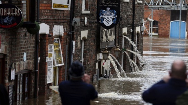
Britain - Update - Many homes remained flooded and without power on Thursday, after heavy rain and strong winds battered northern Britain. Storm Frank spread on Tuesday and Wednesday, damaging property and affecting roads and rail services in England, Scotland and Northern Ireland. The government-affiliated Environment Agency said more than 6,700 homes in the north of England were flooded during the last week as river levels reached all-time highs. Flood warnings remained in place in England, Scotland and Northern Ireland on Thursday.

USA - Update - The death toll from flooding in Missouri rose to 14 Wednesday, and at least two rivers rose higher than during devastating floods in 1993, officials said, but the region was bracing for more flooding.
El Nino set to continue in early 2016
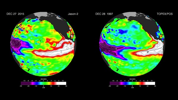
The current strong El Nino brewing in the Pacific Ocean shows no signs of waning, as seen in the latest satellite image from the U.S./European Ocean Surface Topography Mission (OSTM)/Jason-2 mission.
El Nino 2015 has already created weather chaos around the world. Over the next few months, forecasters expect the United States to feel its impacts as well.
The latest Jason-2 image bears a striking resemblance to one from December 1997, by Jason-2's predecessor, the NASA/Centre National d'Etudes Spatiales (CNES) Topex/Poseidon mission, during the last large El Nino event. Both reflect the classic pattern of a fully developed El Nino.
The images show nearly identical, unusually high sea surface heights along the equator in the central and eastern Pacific: the signature of a big and powerful El Nino. Higher-than-normal sea surface heights are an indication that a thick layer of warm water is present.
El Ninos are triggered when the steady, westward-blowing trade winds in the Pacific weaken or even reverse direction, triggering a dramatic warming of the upper ocean in the central and eastern tropical Pacific. Clouds and storms follow the warm water, pumping heat and moisture high into the overlying atmosphere. These changes alter jet stream paths and affect storm tracks all over the world.

No comments:
Post a Comment