Thursday, 30 September 2021

Volcanos

Roundup of Global Volcanic Activity – New Activity for the Week 22 September – 28 September 2021

La Palma – Spain : The eruption at La Palma continued during 21-28 September, characterized by Strombolian explosions, lava fountaining from multiple vents, advancing lava flows, and sometimes dense, daily ash emissions. A strong increase in tremor amplitude during the afternoon of 21 September was coincident with intensifying Strombolian activity. Explosive activity again increased on 22 September and dense plumes with abundant amounts of ash rose 3-4.6 km (10,000-15,000 ft) a.s.l. and caused ashfall in areas downwind; ash deposits were 3 cm thick in an unspecified area 1 km from the vents. The main lava flow advanced W towards the coast. Ash emissions significantly increased on 23 September with plumes rising as high as 5 km (16,400 ft) a.s.l. A series of powerful explosions began at 1720 and shock waves could be seen propagating through the emission plumes. Vigorous lava fountaining was continuous. Volcanic tremor amplitude was high and variable, peaking at 1500 on 24 September with the highest values since the eruption started. The peak occurred just before two new vents opened on the flank of the main cone, and then notably decreased afterwards, but remained at high levels. Lava from the new vents rapidly traveled more than 1 km downslope, covering older flows, before slowing to 60-80 meters per hour. According to a news report, the explosions ejected tephra outside of the exclusion zone. An evacuation order was issued in the early afternoon for Tajuya, Tacande de Abajo, and part of Tacande de Arriba, affecting 300-400 people. Three airlines suspended flights to La Palma. The lava flow field had expanded to 1.9 square kilometers, destroyed more than 420 buildings, and covered 15.2 km of roads.

Tremor amplitude decreased around noon on 25 September, along with the intensity of the Strombolian explosions. During 25-26 September ash fell in nearby municipalities and as far as the E coast of the island. On 26 September the PEVOLCA steering committee recommended that residents who had evacuated two days earlier could return. The report described two main lava flows, with a highly fluid northern flow and a southern flow that was 2.5 km long. Sulfur dioxide emissions remained significant with an average rate of 25,000 tons per day, and ash plumes rose as high as 3 km above the vents. Lava continued to advance and flowed through Todoque, crossing the LP-213 road, just W of the main part of the town, at around 1900. The flow was 600 m across at the widest part and the leading edge was 4-6 m tall. Lava fountaining and low-intensity Strombolian explosions persisted. Copernicus EMS estimated that the lava covered 2.37 square kilometers, had destroyed 513 houses, and covered 18.9 km of roads. Multiple lava fountains feeding flows were visible on 27 September though the activity waned for a period of about eight hours. By the evening activity had resumed and low-intensity Strombolian explosions were visible.

Beginning at 0245 on 28 September lava fountains fed a new high-temperature, fast-moving flow that descended on top of older flank flows. The leading edge of the main flow continued to advance W and covered banana greenhouses, burning the plastic and igniting a storage of fertilizer resulting in small explosions and a brown odorous plume. About 140 more structures were covered by flows. In preparation for a possible ocean entry, authorities recommended that residents within a 5 km radius of the coastline keep their doors and windows closed, to stay away from windows in case they break, and to cover faces and skin in case of ashfall. Dense ash-and-gas plumes continued to rise from the main vents, as high as 5 km; the rising plume created gravity waves that looked like ripples moving away from the top of the plume. Late in the day lava reached the coastal area, descended a 100-m-high sea cliff, and by 2302 reached the ocean at Playa de los Guirres. Black-and-white plumes rose from where the lava contacted the water.

Nyiragongo – DR Congo : OVG reported that lava had returned to Nyiragongo’s summit crater based on a 29 September Sentinel satellite image.


from WordPress https://ift.tt/2WsJlMN

Storms and Floods

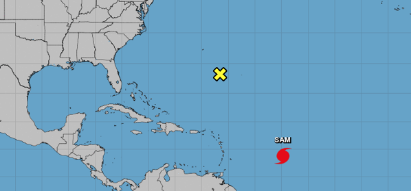
Tropical Storms – Roundup of Tropical Storms:

Screen Shot 2021 09 30 at 11 42 28 AM

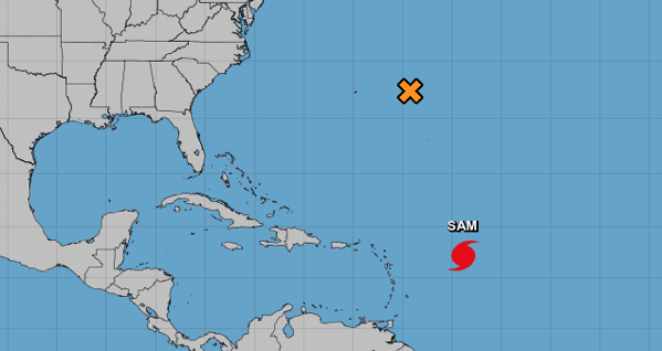
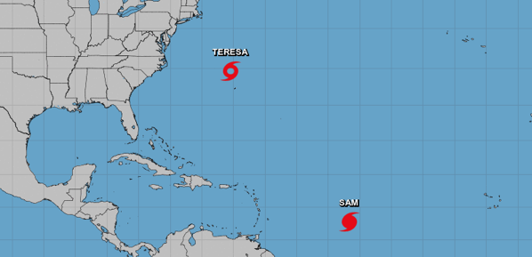
In the Atlantic Ocean: Hurricane Sam is located about 345 mi…555 km ne of the northern Leeward islands and about 825 mi…1325 km sse of Bermuda with maximum sustained winds…145 mph…230 km/h. Present movement…nw or 320 degrees at 12 mph…19 km/h.

Tropical Storm Victor is located about 550 mi…885 km ssw of the Cabo Verde islands with maximum sustained winds…45 mph…75 km/h. Present movement…wnw or 290 degrees at 13 mph…20 km/h.

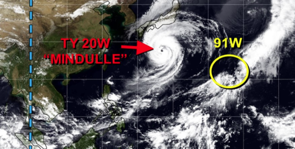
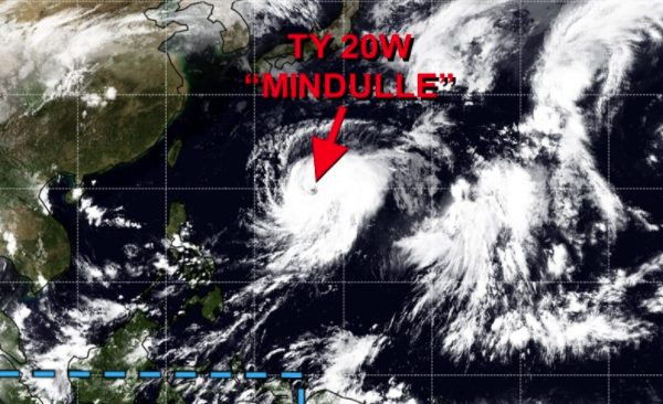
In the Northwest Pacific Ocean: Typhoon 20w (Mindulle), located approximately 455 nm south-southwest of Yokosuka, Japan, is tracking north-northeastward at 15 knots.

Screen Shot 2021 09 30 at 11 57 50 AM


from WordPress https://ift.tt/3AVXWj1

Earthquakes

Magnitude 5+ Earthquakes – Global

There have been no magnitude 5+ earthquakes reported so far today.


from WordPress https://ift.tt/3kUJSAt

Space Events

Spectacular Aurora

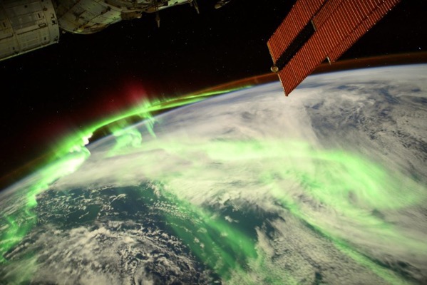
An astronaut shared an epic snap of the aurora from the space station (29 September 2021).

Aurora 1024x683


from WordPress https://ift.tt/3A6E4sh

Disease

Covid-19

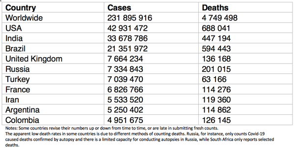
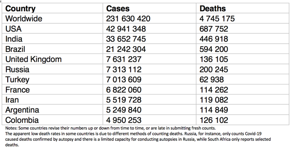
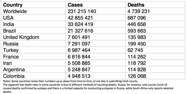
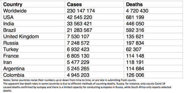
The countries with the 10 greatest number of Covid-19 cases:

Screen Shot 2021 09 30 at 12 08 27 PM


from WordPress https://ift.tt/39PTu9g

Wednesday, 29 September 2021

Earthquakes

Magnitude 5+ Earthquakes – Global

6.1 earthquake hits the Sea of Japan.

5.1 earthquake hits Mendoza, Argentina.

5.1 earthquake hits the South Sandwich Islands.

5.0 earthquake hits Vanuatu.

5.0 earthquake hits south of Fiji.

5.0 earthquake hits the State of Yap, Micronesia.


from WordPress https://ift.tt/3ATCsDk

Storms and Floods

Tropical Storms – Roundup of Tropical Storms:

Screen Shot 2021 09 29 at 12 57 49 PM

In the Atlantic Ocean: Hurricane Sam is located about 455 mi…730 km e of the northern Leeward islands with maximum sustained winds…130 mph…215 km/h. Present movement…nw or 310 degrees at 9 mph…15 km/h.

In the Northwest Pacific Ocean: Typhoon 20w (Mindulle), located approximately 324 nm west of Iwo To, is tracking northward at 08 knots.

Screen Shot 2021 09 29 at 12 55 56 PM

Newsbytes:

India – At least 20 people have lost their lives after Tropical Cyclone Gulab and its remnants brought severe weather and flooding to parts of Odisha, Andhra Pradesh, Telangana and Maharashtra states in India over the last few days. Tropical Cyclone Gulab made landfall between the coastal states of Odisha and Andhra Pradesh on 26 September 2021. Gulab then weakened to a tropical depression as it moved westward and inland. 179,829 people have been affected by Gulab across 1,274 villages in Odisha. As of 28 September, 512 houses were damaged, with the worst damages reported in Koraput and Malkangiri districts. No fatalities were reported however. In Andhra Pradesh, 3,940 people were evacuated ahead of the storm. As of 28 September, a total of 392 villages were affected in the state, with 156 homes damaged. As of 29 September, the worst of the flooding in Maharashtra was in Aurangabad division, also referred to as Marathwada region, situated in the southern central part of state along the border with Telangana.


from WordPress https://ift.tt/3F1RI3f

Wildlife

Whale Dies from Human-Caused Injuries

A dead humpback whale that recently washed up on a beach in Staten Island, New York, showed signs of human-caused injuries that may have contributed to its death, experts found.

An examination of the corpse revealed evidence of recent and serious injuries. Healing wounds around the humpback’s head and mouth resembled injuries caused by entanglement with fishing equipment, and lodged in the whale’s intestines was a large chunk of metal, which had damaged the animal’s digestive tract.

The death again highlights the detrimental effect of human interactions with wildlife.


from WordPress https://ift.tt/3unoXcy

Disease

Covid-19

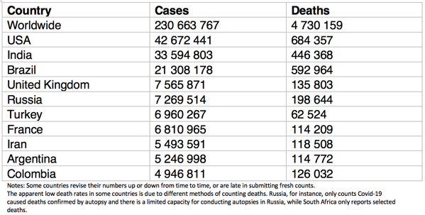
The countries with the 10 greatest number of Covid-19 cases:

Screen Shot 2021 09 29 at 1 04 45 PM


from WordPress https://ift.tt/3idtEkg

Tuesday, 28 September 2021

Earthquakes

Magnitude 5+ Earthquakes – Global

5.1 earthquake hits Crete.

5.1 earthquake hits the Molucca Sea.


from WordPress https://ift.tt/3ARWYUW

Storms and Floods

Tropical Storms – Roundup of Tropical Storms:

Screen Shot 2021 09 28 at 12 14 52 PM

In the Atlantic Ocean: Hurricane Sam is located about 610 mi…980 km e of the northern Leeward islands with maximum sustained winds…130 mph…215 km/h. Present movement…nw or 310 degrees at 9 mph…15 km/h.

In the Northwest Pacific Ocean: Typhoon 20w (Mindulle), located approximately 360 nm west-southwest of Iwo To, is tracking northwestward at 08 knots.

Screen Shot 2021 09 28 at 12 09 41 PM

Newsbytes:

Thailand – Disaster authorities in Thailand report dozens of provinces in the country have been affected by flooding after heavy rain over recent days brought by Tropical Storm Dianmu. Flooding has affected 58,977 households across 27 provinces.


from WordPress https://ift.tt/3kLLKvi

Disease

Covid-19

The countries with the 10 greatest number of Covid-19 cases:

Screen Shot 2021 09 28 at 12 27 04 PM

Anthrax – Namibia

During a National Cheetah Survey in Namibia, three collared cheetah males were found dead. Upon a ground survey it was found that they had died of anthrax. Nearby a zebra carcass infected with anthrax was found. This is the first confirmed anthrax infection in a wildlife species in Namibia.

Meningitis – DR Congo

In a follow-up on the meningococcal meningitis outbreak in Tshopo Province, Democratic Republic of the Congo (DRC), as of September 21, 777 total suspected and confirmed cases have been reported including 167 deaths (CFR= 21.5%) in Panga, Banalia territory, in Kisangani district.


from WordPress https://ift.tt/3ANRVot

Monday, 27 September 2021

Storms and Floods

Tropical Storms – Roundup of Tropical Storms:

Screen Shot 2021 09 27 at 12 39 54 PM

In the Atlantic Ocean: Hurricane Sam is located about 800 mi…1290 km ese of the northern Leeward islands with maximum sustained winds…130 mph…215 km/h. Present movement…nw or 315 degrees at 8 mph…13 km/h.

In the Northwest Pacific Ocean: Typhoon 20w (Mindulle), located approximately 393 nm southwest of Iwo To, is tracking north-northwestward at 03 knots.

Screen Shot 2021 09 27 at 12 38 41 PM

Newsbytes:

Sudan and South Sudan – Ongoing floods in the neighbouring countries of Sudan and South Sudan have affected more than 700,000 people since the start of the rainy season in July this year. Around 100,000 of those affected in South Sudan were initially displaced by floods last year and have not been able to return home since. Heavy rains, infrastructure damage and reduced physical accessibility, funding constraints and insecurity have hampered the flood response, humanitarian agencies say.


from WordPress https://ift.tt/3i7u1wz

Earthquakes

Magnitude 5+ Earthquakes – Global

5.6 earthquake hits Crete.

5.6 earthquake hits Mindoro in the Philippines.

5.0 earthquake hits Tajikistan


from WordPress https://ift.tt/3kL1xuq

Wildfires

Wildfires – California

The Fawn Fire ignited Wednesday afternoon in the area of Fawndale and Radcliff roads, north of Redding, according to Cal Fire. The Fawn Fire has charred an estimated 8,559 acres, or 13 square miles, as of Saturday evening, according to Cal Fire. Some 144 structures have been confirmed destroyed and more than 2,000 remain threatened. The fire is 45% contained. About 4,000 Shasta County residents were forced to evacuate.


from WordPress https://ift.tt/3ALimv1

Disease

Covid-19

The countries with the 10 greatest number of Covid-19 cases:

Screen Shot 2021 09 27 at 12 43 43 PM


from WordPress https://ift.tt/3ibxLgB

Sunday, 26 September 2021

Earthquakes

Magnitude 5+ Earthquakes – Global

5.7 earthquake hits Taiwan.

5.5 earthquake hits the South Sandwich Islands.

5.3 earthquake hits south of Fiji.


from WordPress https://ift.tt/3AXqtEV

Storms and Floods

Tropical Storms – Roundup of Tropical Storms:

Screen Shot 2021 09 26 at 2 08 33 PM

In the Atlantic Ocean: Hurricane Sam is located about 940 mi…1510 km ese of the northern Leeward islands with maximum sustained winds…145 mph…230 km/h. Present movement…wnw or 295 degrees at 8 mph…13 km/h.

In the Northwest Pacific Ocean: Super Typhoon 20w (Mindulle), located approximately 442 nm southwest of Iwo To, is tracking westward at 03 knots.

Tropical cyclone 03b (Gulab), located approximately 281 nm south-southwest of Kolkata, India, is tracking westward at 10 knots.

Screen Shot 2021 09 26 at 2 05 39 PM


from WordPress https://ift.tt/3uduUsl

Environment

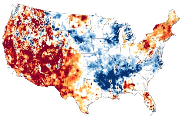
Drought in the US Southwest is worst in recorded history

The ongoing drought in the U.S. Southwest is the worst drought the region has experienced since record keeping began in 1895, according to a new report from the National Oceanic and Atmospheric Association (NOAA) Drought Task Force.

The 20 months from January 2020 through August 2021 saw the lowest total precipitation and the third-highest daily average temperatures ever recorded in the Southwest (which encompasses Arizona, California, Colorado, Nevada, New Mexico and Utah), resulting in an “unyielding, unprecedented and costly” crisis, the report said.

While the drought punctuates a two-decades-long period of declining precipitation in the Southwest that is “presumably natural,” human-induced climate change exacerbated the current drought significantly by driving up average temperatures to scorching highs, the report found. Together, the low precipitation and searing temperatures reduced the area’s mountain snowpack and increased water evaporation in Southwestern soil, leading to the severe and persistent drought.

KrPYQymHddX5YyanayMr7a


from WordPress https://ift.tt/3CPe9qu

Disease

Covid-19

The countries with the 10 greatest number of Covid-19 cases:

Screen Shot 2021 09 26 at 2 14 10 PM

Botulism – Russia

Health authorities in Tatarstan report twelve botulism cases this year in the districts of Almetyevsky, Zainsky, Leninogorsky and Sarmanovsky. This compares with two botulism cases reported in the previous two years.

Typhoid – Mexico

Tamaulipas state, on the west coast of Mexico and bordering Texas has reported 3,407 typhoid fever infections since the beginning of the year. This puts Tamaulipas at the top of cases reported in any one state, closely followed by Sinaloa state (3381).


from WordPress https://ift.tt/39EOxjC

Saturday, 25 September 2021

Storms and Floods

Tropical Storms – Roundup of Tropical Storms:

Screen Shot 2021 09 25 at 12 58 50 PM

In the Atlantic Ocean: Hurricane Sam is located about 1150 mi…1855 km ese of the northern Leeward islands with maximum sustained winds…110 mph…175 km/h. Present movement…wnw or 290 degrees at 13 mph…20 km/h.

Subtropical Storm Theresa is located about 155 mi…255 km nnw of Bermuda with maximum sustained winds…40 mph…65 km/h. Present movement…wnw or 285 degrees at 6 mph…9 km/h.

In the Northwest Pacific Ocean: Typhoon 20w (Mindulle), located approximately 467 nm west of Agrihan, is tracking northwestward at 07 knots.

Tropical cyclone 03b (Three), located approximately 267 nm south of Kolkata, India, is tracking westward at 06 knots.

Screen Shot 2021 09 25 at 12 56 45 PM

Newsbytes:

Pakistan – Heavy monsoon rain caused severe traffic problems in parts of Karachi, Pakistan’s largest city on 23 September 2021. Roads were flooded and cars submerged. Rain began early on 23 September. By the afternoon as much as 70 mm had fallen in Surjani Town on the northern outskirts of the city, according to figures from Pakistan Meteorological Department (PMD). As of 09 September 187 people have died in rain-related incidents since 01 July and the start of this year’s monsoon.

Spain – Torrential rain of over 100mm in 1 hour caused damaging flash floods in Huelva Province on the coast of Andalusia, southern Spain, on 23 September 2021. According to Spain’s meteorological agency AEMET, the town of Cartaya in the Province of Huelva recorded 118 mm of rain during a storm on 23 September, with 112.4 mm of rain falling in just 1 hour. Raging flood water swept though streets of numerous towns in the area, wrecking vehicles and damaging buildings.


from WordPress https://ift.tt/3i5Tmay

Earthquakes

Magnitude 5+ Earthquakes – Global

6.2 earthquake hits the Andreanof Islands in the Aleutian Islands.

5.4 earthquake hits south of Africa.

5.4 earthquake hits the Nicobar Islands off India.

5.0 earthquake hits eastern Xizang, China.

5.0 earthquake hits Guadeloupe in the Leeward Islands.


from WordPress https://ift.tt/3CFC3om

Disease

Covid-19

The countries with the 10 greatest number of Covid-19 cases:

Screen Shot 2021 09 25 at 1 16 36 PM


from WordPress https://ift.tt/3o7Nnpe

Friday, 24 September 2021

Earthquakes

Magnitude 5+ Earthquakes – Global

5.6 earthquake hits off the coast of Baja California Sur.

5.6 earthquake hits the Andreanof Islands in the Aleutian Islands.

5.3 earthquake hits the Gulf of California.

5.1 earthquake hits the Kermedec Islands.

5.1 earthquake hits the Molucca Sea.

5.0 earthquake hits near the coast of Nicaragua.


from WordPress https://ift.tt/3lOenHu

Storms and Floods

Tropical Storms – Roundup of Tropical Storms:

Screen Shot 2021 09 24 at 12 10 02 PM

In the Atlantic Ocean: Hurricane Sam is located about 1470 mi…2365 km ese of the northern Leeward islands with maximum sustained winds…75 mph…120 km/h. Present movement…w or 280 degrees at 15 mph…24 km/h.

In the Northwest Pacific Ocean: Tropical storm 21w (Dianmu), located approximately 59 nm southeast of Da Nang, Vietnam, is tracking northwestward at 15 knots.

Tropical storm 20w (Mindulle), located approximately 965 nm southeast of Kadena AFB, is tracking northwestward at 10 knots.

Tropical cyclone 03b (Three), located approximately 211 nm south of Chittagong, is tracking northwestward at 15 knots.

Screen Shot 2021 09 24 at 12 11 15 PM

Newsbytes:

Colombia – Flooding continues to affect thousands of people across several departments of northern Colombia after rivers overflowed, dams and embankments failed and further heavy rain. In a report of 22 September the organisation said 12,441 people were still affected in Magangué, where 2,181 homes and 7,000 hectares of land have been flooded. Also in the north of the country, flooding affected Puerto Wilches municipality of Santander Department in the first week of September, according to Civil Defence. A total of 278 people were affected and 40 homes damaged. In Sucre Department, northern Colombia after heavy rain from 22 September 2021, some homes were evacuated. Civil Defence reported 1,715 people affected and 343 homes damaged.


from WordPress https://ift.tt/3EN9ozF

Global Warming

Melting Polar Ice Warps Earth’s Crust

As the polar ice sheets melt, the process is not just raising sea levels – it’s also warping the underlying surface of Earth, a new study reveals, and some of the effects can be seen across thousands of miles.

What’s happening is that Earth’s crust is rising and spreading as the weight of the ice across Greenland, Antarctica, and the Arctic Islands gets lifted. The movement isn’t huge, averaging less than a millimeter a year, but it’s there and it covers a lot of ground.

The changes in the Earth’s crust may lead to altered tectonic movements over time, further affecting how the ice continues to melt.

Ozone Hole

The annual hole in the layer of stratospheric ozone over Antarctica has surged in size to now cover an area larger than the continent itself. Stratospheric ozone helps protect the Earth’s surface from dangerous ultraviolet radiation.

While a worldwide ban on the chemicals responsible for ozone depletion is showing signs of helping the hole to heal, scientists say it will still take decades because those chemicals are slow to break down. The European Space Agency says this year’s hole is now larger than 75% of those since the late 1970s. The ozone holes typically reach their largest size between mid-September and mid-October.

EWCOLOR

Climate Change Fuels Migration – Guatemala

The agricultural economy of Guatemala has been hit by intense droughts alternating with devastating floods – two extremes made worse by climate change.

In Guatemala, years of severe drought interspersed with tropical storms, Hurricanes Eta and Iota last year and other heavy precipitation events have not only destroyed crops but also battered the land. Plants no longer grow and the soil remains infertile. This situation has caused severe food insecurity where almost half of children under five years old suffer malnutrition.

In the result, people are migrating away from rural areas to cities and other countries where prospects to earn a living are more favourable. While there is no clear definition, legal or otherwise, on who is a climate migrant, climate change is rarely the main reason why someone decides to leave their home, but it’s almost certainly a compounding factor in many cases.


from WordPress https://ift.tt/2XG2TO2

Wildlife

Orcas vs Boats

An increasing number of boats off Spain and Portugal are mysteriously being attacked by orcas, with one sailboat being bashed by about a dozen of the “killer whales” for two hours.

A total of 41 attacks were reported in July alone, with most near Gibraltar.

Orcas had previously been known to lurk around fishing boats and steal tuna that had been caught. But the new encounters are stumping marine scientists, who are not sure they are actual attacks. “I don’t think we can consider them attacks if we can’t fully understand their motivation,” said cetacean expert Susana García-Tiscar.


from WordPress https://ift.tt/2XOgH9O

Environment

Global Temperature Extremes

The week’s hottest temperature was 45.0 degrees Celsius at Yanbu, Saudi Arabia.

The week’s coldest temperature was minus 71.6 degrees Celsius at Vostok, Antarctica.

Temperatures were tabulated from the more than 10,000 worldwide synoptic weather stations. The United Nations World Meteorological Organization sets the standards for weather observations, and provides a global telecommunications circuit for data distribution.


from WordPress https://ift.tt/3ufRgtl

Disease

Covid-19

The countries with the 10 greatest number of Covid-19 cases:

Screen Shot 2021 09 24 at 12 16 42 PM

African Swine Fever -0 Dominican Republic

On July 28, the U.S. Department of Agriculture’s (USDA) Animal and Plant Health Inspection Service (APHIS) reported samples collected from pigs in the Dominican Republic were positive for African Swine Fever (ASF). This is the first time the disease was seen in the Americas in 40 years.

Plague – Madagascar

As of September 16, a total of 38 suspected cases of pulmonary plague including 19 confirmed and 6 death cases (CFR= 15.8%) are reported so far. The cases have all been from the Itasy region.


from WordPress https://ift.tt/39xKGF1

Volcanos

Roundup of Global Volcanic Activity – Ongoing Activity for the Week 15 September – 21 September 2021

Agung – Bali (Indonesia) : PVMBG reported that activity at Agung was last observed on 13 June 2019 and a thermal anomaly over the crater was last identified in satellite images in October 2019. During the previous year deformation data indicated no changes at the volcano and seismicity decreased. During 1 Janaury-13 September white gas-and-steam plumes rose 20-50 m above the summit.

Aira – Kyushu (Japan) : JMA reported that an explosion at Minamidake Crater (at Aira Caldera’s Sakurajima volcano) at 1617 on 19 September produced an eruption plume that rose 1 km above the crater rim. Crater incandescence was visible at night during 20-21 September. The report noted that inflation around the summit continued to be recorded.

Chirinkotan – Kuril Islands (Russia) : SVERT and KVERT reported that volcanic activity at Chirinkotan was last observed during 23-24 August. The Aviation Color Code was lowered to Green in mid to late September.

Ebeko – Paramushir Island (Russia) : According to volcanologists in Severo-Kurilsk (Paramushir Island), about 7 km E of Ebeko, explosions during 10-11 September produced ash plumes that rose as high as 2 km (6,600 ft) a.s.l. and drifted S and SE.

Etna – Sicily (Italy) : INGV reported that tremor amplitude at Etna began gradually increasing at 0420 on 21 September and then suddenly increased at 0440. Ash emissions rose from the Southeast Crater (SEC) at 0815 and by 0855 Strombolian activity was visible. An eruption plume rose 4.5 km above the summit and drifted ENE. Within an hour lava fountaining began and the plume rose 9 km and drifted ENE. Lava overflowed the crater and traveled SW. Lava fountaining had ceased by 1130, though Strombolian activity within the crater continued. Tremor amplitude decreased at 1250 and explosive activity ceased.

Great Sitkin – Andreanof Islands (USA) : AVO reported that lava effusion continued at Great Sitkin during 15-21 September, though weather clouds often prevented webcam and satellite views. Seismicity remained elevated and was characterized by small earthquakes consistent with lava effusion. A radar image from 16 September indicated that the lava dome had grown to 1,130 m E-W and 910 m N-S, and was about 30 m thick. The edges of the dome touched the S and W rims of the crater. Elevated surface temperatures were identified in satellite data during 20-21 September.

Karymsky – Eastern Kamchatka (Russia) : KVERT reported that a thermal anomaly over Karymsky was identified in satellite images during 10-17 September. Ash plumes rose as high as 7 km (23,000 ft) a.s.l. and drifted 180 km E and SE during 10 and 15-16 September.

Katmai – United States : AVO reported that on 21 September strong winds in the vicinity of Katmai and the Valley of Ten Thousand Smokes blew unconsolidated ash SE towards Kodiak Island at an altitude up to 2.4 km (8,000 ft) a.s.l. The ash was originally deposited during the Novarupta eruption in 1912.

Krysuvik-Trolladyngja – Iceland : The eruption from the fifth vent in the W part of the Krýsuvík-Trölladyngja volcanic system, close to Fagradalsfjall on the Reykjanes Peninsula, continued during 15-18 September. According to a news article lava ponded for a few days in Geldingadalur, and during 14-15 September the crust ruptured and sent a larger lava flow rapidly into the S part of the valley; the flow then turned E into the Nàtthagi valley. Authorities temporarily closed the area due to the activity and the large number of tourists; the Coast Guard rescued two people whose exit route had been cut off by the flow. Lava continued to flow on this path during 16-17 September and overtook the “A” hiking trail. Later that day at around 1800 the flow rate decreased or paused, and only minor incandescence from the vent was visible. The Institute of Earth Sciences reported that based on aerial photography acquired on 17 September the area of the flow field had grown to 4.8 square kilometers, and the total volume erupted was 151 million cubic meters. The lava-flow rate during 11-17 September averaged 16 cubic meters per second. IMO noted that 19 September marked six months since the eruption started.

Merapi – Central Java (Indonesia) : BPPTKG reported that no morphological changes to Merapi’s two lava domes, situated just below the SW rim and in the summit crater, were detected during 10-16 September. As many as 144 lava avalanches traveled a maximum of 2 km SW.

Pavlof – United States : AVO reported that periods of elevated seismic tremor with no clear explosion signals were recorded at Pavlof during 14-18 September. Webcam images were mostly obscured by weather clouds. Minor ash deposits on the upper flanks and at least one minor ash emission was visible in a clear webcam view on 18 September. Small low-level ash emissions that dissipated quickly were noted by observers and visible in webcam images at 1500 on 19 September and at 0900 on 20 September. Ash deposits on the mid-flanks were identified in satellite data. Seismicity remained elevated during 2021 September; an explosion was recorded early on the 21 September. The vent in the crater continued to migrate N based on satellite data.

Popocatepetl – Mexico : CENAPRED reported that each day during 14-21 September there were 89-152 steam-and-gas emissions from Popocatépetl. The plumes drifted mainly NW and some contained ash. As many as five daily explosions were recorded during 14-19 September and some ejected incandescent material onto the flanks. Explosions at 1818, 1839, and 2350 on 14 September produced ash plumes that rose 1.2-1.5 km above the crater rim. Explosions at 1015 and 1441 on 15 September produced ash plumes that rose 1.8-2.2 km. During 15-17 September minor ashfall was reported in the municipalities of Cuernavaca, Valle de Chalco, Chiautla, Ixtapaluca, Nezahualcóyotl, La Paz, Ecatepec, Ayapango, Temamatla, Tenango del Aire, Tlalmanalco, Amecameca, Tepetlixpa, Tlalnepantla, and Acolman in the México State, and in Iztapalapa, Xochimilco, and Tlahuac in México City.

Sheveluch – Central Kamchatka (Russia) : KVERT reported that a thermal anomaly over Sheveluch was identified in satellite images during 10-17 September.

Soufriere St. Vincent – St. Vincent : National Emergency Management Organisation (NEMO) reported that activity at Soufrière St. Vincent had been low over the previous few months.

Suwanosejima – Ryukyu Islands (Japan) : JMA reported that the number of daily explosions at Suwanosejima’s Ontake Crater increased on 16 September and remained elevated through 20 September. Eruption plumes rose as high as 2.4 km above the crater rim and material was generally ejected 300 m away from the crater. Notably, explosions at 2014 on 16 September and at 0212 on 17 September ejected material almost 1 km S and SE, respectively.


from WordPress https://ift.tt/3ua0Z4z

Thursday, 23 September 2021

Earthquakes

Magnitude 5+ Earthquakes – Global

6.6 earthquake hits near the coast of Nicaragua.

5.9 earthquake hits near the coast of Nicaragua.

5.5 earthquake hits central Mongolia.

5.3 earthquake hits the Molucca Sea.

5.3 earthquake hits Chitinskaya Oblast, Russia.

5.2 earthquake hits near the coast of Nicaragua.

5.1 earthquake hits the Kermedec Islands.

Two 5.0 earthquakes hit the South Sandwich Islands.

5.0 earthquake hits offshore Bio-Bio, Chile.

5.0 earthquake hits the Kermedec Islands.


from WordPress https://ift.tt/3zEDJwl

Storms and Floods

Tropical Storms – Roundup of Tropical Storms:

Screen Shot 2021 09 23 at 11 59 31 AM

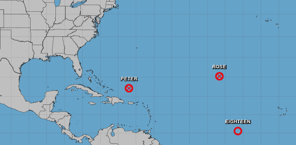
In the Atlantic Ocean: Remnants of Peter are located about 260 mi…420 km nnw of San Juan Puerto Rico with maximum sustained winds…30 mph…45 km/h. Present movement…nnw or 335 degrees at 5 mph…7 km/h.

Post Tropical Cyclone Rose is located about 1300 mi…2095 km wnw of the Cabo Verde islands with maximum sustained winds…35 mph…55 km/h. Present movement…nw or 310 degrees at 10 mph…17 km/h.

Tropical Depression Eighteen is located about 1860 mi…2995 km ese of the northern Leeward islands with maximum sustained winds…35 mph…55 km/h. Present movement…w or 280 degrees at 15 mph…24 km/h.

In the Northwest Pacific Ocean: Tropical storm 21w (Dianmu), located approximately 150 nm southeast of Da Nang, Vietnam, is tracking northwestward at 13 knots.

Tropical storm 20w (Twenty), located approximately 19 nm south-southwest of Hagatna, Guam, is tracking west-northwestward at 14 knots.

Screen Shot 2021 09 23 at 11 59 09 AM

Newsbytes:

India – Days of heavy rain, rising rivers and dam releases have caused widespread flooding in the state of Odisha in eastern India, where authorities report 26 districts affected. Many parts of Odisha experienced heavy rainfall from around 13 September, brought by a Low Pressure Area over the Bay of Bengal. In a 24 hour period to 13 September, Puri recorded 343 mm of rain. The rain caused several rivers in the state to swell or break their banks. As of 19 September flooding had affected over 2.7 million people across 6,129 villages of 26 districts in Odisha.


from WordPress https://ift.tt/2XKpABd

Wildlife

Australia Loses 30% of its Koalas to Wildfires

Australia has lost 30 per cent of its koala population in the last three years due to the blazing bushfires in Victoria and New South Wales. Warning about the rapid decline in the population of koalas, the Australian Koala Foundation has said the numbers are dropping at an alarming rate.


from WordPress https://ift.tt/3AMI4Pq

Wildfires

Wildfires – California

The twin blazes pf the Windy and KNP Complex fires continued to threaten California’s towering sequoia trees and create new miseries for nearby residents, spewing smoke and worsening air quality across Central California on Wednesday. The two fires have burned through nearly 60,000 acres combined, officials said, with hardly any containment.

Days-long efforts to defend Sequoia National Park’s most famous trees from the 28,241-acre KNP Complex have proven mostly successful so far, with crews crediting proactive firefighting and a history of prescribed burns for preventing significant damage to the Giant Forest, including the General Sherman tree and the Four Guardsmen trees. Fire-resistant material has also been placed around the bases of some of the most famous forest inhabitants, including the General Sherman Tree, the largest in the world by volume.


from WordPress https://ift.tt/3kwFfMY

Disease

Covid-19

The countries with the 10 greatest number of Covid-19 cases:

Screen Shot 2021 09 23 at 12 07 28 PM

Yellow Fever – Ivory Coast

Five cases of yellow fever have been reported from Côte d’Ivoire on 13 September 2021. Yellow fever is an acute viral hemorrhagic fever. Symptoms of yellow fever (fever, chills, headache, backache, and muscle aches) develop 3-6 days after infection. About 15% of people infected with yellow fever virus will develop severe illness that can lead to liver disease, bleeding, shock, organ failure, yellowing skin (jaundice), and sometimes death.

Monkeypox – DR Congo

The World Health Organization (WHO) reported 69 additional suspected monkeypox cases in the past month in the Democratic Republic of the Congo (DRC), bringing the cumulative total since the beginning of the year to 8,849. In addition, three more deaths were recorded, bringing the monkeypox death to for 2021 to 69.


from WordPress https://ift.tt/3kzpXXS

Volcanos

Roundup of Global Volcanic Activity – New Activity for the Week 15 September – 21 September 2021

La Palma – Spain : An eruption began at La Palma after about a week of intensifying seismicity that showed hypocenters becoming shallower and moving NW, and significant related inflation. During 17-18 September the PEVOLCA (Plan de Emergencias Volcánicas de Canarias) steering committee (comprised of representatives from multiple agencies, local authorities, and institutions) reviewed mitigation, evacuation, and emergency plans. Helicopter and drone overflights were conducted in areas thought to be at risk from an eruption. IGN reported that during 17-18 September seismicity decreased, though an M 2 felt by local residents was located at 100 m depth, and vertical deformation occurred near the earthquake epicenters. IGN noted that seismicity intensified during the morning of 19 September, with earthquakes located at 0-6 km depth; a M 4.2 event was recorded at 1116 and vertical deformation increased. Authorities evacuated about 50 residents with reduced mobility and their companions from Las Manchas de Abajo, Jedey, San Nicolás and El Paraíso (El Paso and Los Llanos de Aridane), El Charco (Fuencaliente), La Bombilla (Los Llanos de Aridane and Tazacorte), and El Remo and Puerto Naos (Los Llanos de Aridane). Residents in an area prone to landslides were also evacuated. Other preparations continued at the hospital, in neighborhoods, and at evacuation centers. At 1510 on 19 September an eruption began in the area of Cabeza de Vaca, in the municipality of El Paso. Observers near the eruption site observed a large explosion that ejected material and produced a gas-and-ash plume; volcanic tremor was recorded by the seismic network. Two 200-m-long fissures aligned N-S opened about 200 m apart. INVOLCAN scientists observed seven vents along the fissures during the initial stage of the eruption. Multiple tall lava fountains fed flows downslope to the W, igniting forest fires. Photos and video posted by IGN showed multiple pulsating fountains fanning out from parts of the fissure. Ash plumes rose about 1.5 km and gas plumes rose 3 km and drifted ESE. The PEVOLCA steering committee briefly raised the Alert Level to Orange, and then to Red (the highest level on a four-color scale) by 1700 for high-risk municipalities directly affected by the eruption. About 5,500 people evacuated with no injuries reported, and authorities recommended that residents stay at least 2 km from the vents. The La Palma airport briefly closed, livestock were evacuated, and education centers were closed along with sections of multiple highways. Later that day INVOLCAN scientists who measured an area of the flows determined an average flow rate of 700 m per hour and temperatures around 1,075 degrees Celsius. By the next day a main cone had formed. The sulfur dioxide gas emission rate was 6,000-11,500 tons per day during 19-20 September. Satellite data showed a plume of sulfur dioxide drifting 475 km SE and reaching the coastline of Africa by 20 September. A map produced on 20 September by IGN in partnership with Copernicus Emergency Management Service (EMS) showed that the main part of the lava flow had traveled more than 3 km W and another branch extended about 1.5 km WSW. The flows had covered about 1 square kilometer and destroyed an estimated 166 buildings. A news article noted that activity was concentrated at four main vents, the last (and ninth) of which opened at 1956 on 20 September about 900 m from the main vents. Strong lava fountaining continued during 20-21 September and ash fell in the vicinity of the vents. Ash plumes rose 2.4-4.6 km (8,000-15,000 ft) a.s.l. and drifted as far as 55 km SW and S according to the Toulouse VAAC. Sulfur dioxide gas plumes drifted W and E at an altitude of 3 km (10,000 ft) a.s.l. By 0814 on 21 September an updated Copernicus EMS map showed that 350 homes had been covered by lava and the flow field had expanded to 1.54 square kilometers. According to a news report lava up to 12 m thick was advancing at a rate of 200 m per hour. A few hundred more residents evacuated as lava advanced towards Tacande; bringing the number of evacuees to about 5,700. The S lava branch was advancing slowly, at a rate of 2 m per hour. Later that day INVOLCAN stated that increased volcanic tremor amplitude reflected greater intensity of Strombolian explosions at the vents.

Semisopochnoi – Aleutian Islands (USA) : AVO reported that eruptive activity at Semisopochnoi’s North Cerberus crater continued during 15-21 September. Weather clouds obscured views of the volcano on most days. Several small daily explosions were recorded by local seismic stations; ash plumes were not visible in satellite images suggesting that they remained below 3 km (10,000 ft) a.s.l. and did not rise above the cloud deck. Overnight during 18-19 September small, discontinuous, low-level ash plumes were visible drifting 100 km SE. Ash emissions increased in frequency and intensity on 19 September. Ash clouds rose as high as 4.6 km (15,000 ft) a.s.l. and continued to drift 100 km SE. Sulfur dioxide emissions increased in the afternoon. AVO raised the Aviation Color Code to Red and the Volcano Alert Level to Warning at 2158. Explosions continued overnight and the next day, and ash plumes rose up to 4.6 km a.s.l. Plumes drifted 100 km NW. At 2012 on 20 September AVO lowered the Aviation Color Code to Orange noting the frequency of discrete explosions had decreased to a rate of about one per hour, though ash plumes from these events were still rising to 4.6 km a.s.l. and drifting NW. Sulfur dioxide plumes drifted N during 20-21 September.


from WordPress https://ift.tt/3lOl1Og

Wednesday, 22 September 2021

Earthquakes

Magnitude 5+ Earthquakes – Global

6.0 earthquake hits offshore Bio-Bio, Chile.

5.7 earthquake hits near the south east coast of Australia.

5.5 earthquake hits the South Sandwich Islands.

5.2 earthquake hits Easter Island.

5.2 earthquake hits the Izu Islands off Japan.

5.1 earthquake hits the Pacific-Antarctic ridge.

5.0 earthquake hits south of Panama.

5.0 earthquake hits Mindoro in the Philippines.


from WordPress https://ift.tt/3kvCRWT

Storms and Floods

Tropical Storms – Roundup of Tropical Storms:

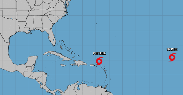
In the Atlantic Ocean: Tropical Depression Peter is located about 215 mi…345 km n of San Juan Puerto Rico with maximum sustained winds…35 mph…55 km/h. Present movement…nw or 310 degrees at 12 mph…19 km/h.

Tropical Depression Rose is located about 1065 mi…1715 km wnw of the Cabo Verde islands with maximum sustained winds…35 mph…55 km/h. Present movement…nw or 325 degrees at 8 mph…13 km/h.

Screen Shot 2021 09 22 at 12 17 06 PM

Newsbytes:

India – Days of heavy rain, rising rivers and dam releases have caused widespread flooding in the state of Odisha in eastern India, where authorities report 26 districts affected. Many parts of Odisha experienced heavy rainfall from around 13 September, brought by a Low Pressure Area over the Bay of Bengal. In a 24 hour period to 13 September, Puri recorded 343 mm of rain. The rain caused several rivers in the state to swell or break their banks. As of 19 September flooding had affected over 2.7 million people across 6,129 villages of 26 districts in Odisha.


from WordPress https://ift.tt/3nVCPtj

Global Warming

Record-Breaking Carbon Emissions

The amount of carbon emitted from severe wildfires that tore across many parts of the Northern Hemisphere this summer broke records, according to data from the European Union’s Copernicus Atmosphere Monitoring Service published Tuesday.

Intense blazes, including fires in hotspots in the Mediterranean, North America and Siberia, let off more than 2.7 billion metric tons of carbon over the summer, with July and August both breaking monthly records for emissions from fires. More than half of July’s emissions could be put down to fires in North America and Siberia.

Europe experienced its hottest summer on record this year and the Mediterranean also broke temperature records by large margins, as did parts of the Arctic and Canada.

Meanwhile, wildfires in the Arctic — a region that has warmed more than twice as fast as the rest of the planet since 2000 — released 66 million tons of CO2 between June and August, Copernicus said.


from WordPress https://ift.tt/2W4qYO8

Wildfires

Wildfires – Nebraska, USA

Authorities in western Nebraska’s Panhandle say two wildfires that had neared Scottsbluff and Crawford have largely been brought under control. The fire southwest of Scottsbluff that has burned about 3,600 acres was 100% contained by Monday afternoon, while the fire south of Crawford that has burned 5,400 acres was halfway contained.


from WordPress https://ift.tt/2XS7QUh

Disease

Covid-19

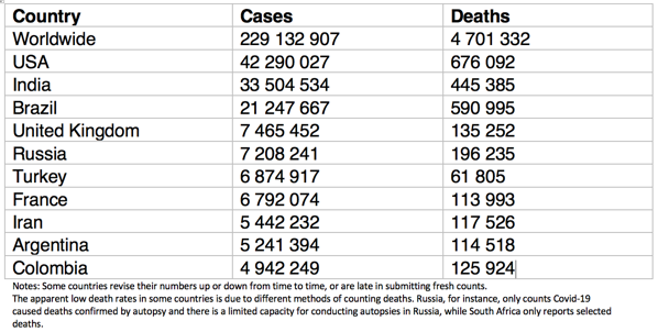
The countries with the 10 greatest number of Covid-19 cases:

Screen Shot 2021 09 22 at 12 16 38 PM


from WordPress https://ift.tt/3ECwskJ

Tuesday, 21 September 2021

Earthquakes

Magnitude 5+ Earthquakes – Global

6.2 earthquake hits the Kuril Islands.

5.7 earthquake hits the South Sandwich Islands.

5.6 earthquake hits Tonga.

5.4 earthquake hits the Kermedec Islands.

5.1 earthquake hits offshore Bio-Bio, Chile.

5.1 earthquake hits Seram, Indonesia.

5.0 earthquake hits Tonga.

5.0 earthquake hits Guatemala.


from WordPress https://ift.tt/3CyPne6

Storms and Floods

Tropical Storms – Roundup of Tropical Storms:

Screen Shot 2021 09 21 at 12 11 51 PM

In the Atlantic Ocean: Tropical Storm Peter is located about 105 mi…170 km nnw of the northern Leeward islands with maximum sustained winds…50 mph…85 km/h. Present movement…w or 265 degrees at 12 mph…19 km/h.

Tropical Storm Rose is located about 880 mi…1420 km wnw of the Cabo Verde islands with maximum sustained winds…45 mph…75 km/h. Present movement…nw or 325 degrees at 20 mph…31 km/h.

Newsbytes:

India – At least 10 people have lost their lives as a result of severe flooding in the state of West Bengal, eastern India. Flooding struck in the state after days of heavy rain from 14 September 2021. The situation was worsened after dam releases from the Galudih Barrage Dam on the Subarnarekha river in Ulda in the neighbouring state of Jharkhand.


from WordPress https://ift.tt/3ztymA0

Disease

Covid-19

The countries with the 10 greatest number of Covid-19 cases:

Screen Shot 2021 09 21 at 12 16 06 PM

Dengue Fever – Dominican Republic

Twelve children were admitted over the weekend to the Robert Reid Cabral children’s hospital suffering from dengue fever. Currently the hospital has 14 children interned due to the disease.


from WordPress https://ift.tt/3CwY4Wt

Monday, 20 September 2021

Earthquakes

Magnitude 5+ Earthquakes – Global

5.2 earthquake hits Myanmar-India border.


from WordPress https://ift.tt/2XyUFHy

Storms and Floods

Tropical Storms – Roundup of Tropical Storms:

Screen Shot 2021 09 20 at 12 51 04 PM

In the Atlantic Ocean: Tropical Storm Peter is located about 245 mi…390 km ene of the northern Leeward islands with maximum sustained winds…50 mph…85 km/h. Present movement…wnw or 290 degrees at 14 mph…22 km/h.

Tropical Storm Rose is located about 550 mi…885 km w of the southernmost Cabo Verde islands with maximum sustained winds…40 mph…65 km/h. Present movement…nw or 315 degrees at 15 mph…24 km/h.

Newsbytes:

USA – Heavy rain caused flash flooding in Alabama, USA on 18 September 2021. Roads were closed and one person died in a vehicle caught in flood water in Tuscaloosa.

Chad – Ongoing flooding in the country of Chad in north-central Africa has affected almost 250,000 people. Flooding first struck parts of the country in late June and the start of the rainy season. Five people died in south-western Tandjilé Region on 26 June. By late July flooding had affected thousands of people across the regions of Tandjilé, Mandoul, Ennedi-Ouest, N’Djamena and Batha. Flooding has affected 246,851 people from 41,267 families across 400 villages. Fifteen people have lost their lives and 17 are reported missing. A total of 329 people have been injured.

India – Heavy rains from 15 September 2021 caused severe flooding in several districts of Uttar Pradesh state in northern India. Disaster authorities in the country reported as many as 58 people have lost their lives in incidents related to severe weather from15 to 19 September. In a 24 hour period to 15 September 2021, Fursatganj recorded 186 mm of rain, Sultanpur 118 mm and Lucknow 107 mm. The following day Barabanki saw 176 mm, Lucknow a further 128 mm, Kanpur 102 mm and Hardoi 112 mm. The rain caused river levels to rise and as of 17 September, the Kwano, Sarda, Ganges and Ghagra rivers were above danger levels in several districts including Gonda, Ayodhya, Kheri, Badaun and Ballia.

Nigeria – The UN reports that over 100,000 people have been directly affected by flash floods in Adamawa State of northeastern Nigeria, including the state capital Yola. The UN has warned of an increased risk of cholera in the region. The number of suspected cholera cases continued to climb across 6 LGAs of Yola North, Yola South, Shelleng, Gombi, Girei and Fufore. As of 7 September, 169 cases and 7 fatalities had been reported.

Uganda – Severe flooding and damaging landslides struck in Eastern Region of Uganda after heavy rainfall from 17 September 2021. One person died and 3 were hospitalised after a landslide destroyed a house in Kapchorwa district. Red Cross reported several landslides in Kapachorwa after close to 10 hours of heavy rain. Waters from the swollen Manafwa river were affecting areas in Mbale. Several villages in Kween district also saw flooding.


from WordPress https://ift.tt/3EAn8gT

Disease

Covid-19

The countries with the 10 greatest number of Covid-19 cases:

Screen Shot 2021 09 20 at 2 08 42 PM

Lassa fever – Nigeria

The Nigeria Centre for Disease Control (NCDC) reported an additional four confirmed Lassa fever cases the week ending September 12, including three deaths among the confirmed cases. This brings the cumulative total confirmed cases this year to 369, including 76 deaths (20.6% CFR).

Dengue Fever – Bangladesh

Bangladesh health authorities reported an additional 241 new dengue patients who were hospitalized Sunday morning. Approximately three quarters (76%) of the new cases were reported in the capital city of Dhaka, while the remaining 57 cases were reported elsewhere in the country. This brings the case total in the country this year at 15,701.


from WordPress https://ift.tt/3AxnGlC

Sunday, 19 September 2021

Earthquakes

Magnitude 5+ Earthquakes – Global

5.6 earthquake hits eastern New Guinea, Papua New Guinea.

5.1 earthquake hits Tonga.

5.1 earthquake hits Vanuatu.

5.0 earthquake hits Tajikistan.

5.0 earthquake hits offshore El Salvador.

5.0 earthquake hits the Solomon Islands.

5.0 earthquake hits offshore Coquimbp, Chile.

5.0 earthquake hits eastern Honshu, Japan.


from WordPress https://ift.tt/3zhTCZC

Storms and Floods

Tropical Storms – Roundup of Tropical Storms:

In the Atlantic Ocean: Tropical Storm Peter is located about 630 mi…1015 km e of the northern Leeward islands with maximum sustained winds…40 mph…65 km/h. Present movement…nw or 305 degrees at 15 mph…24 km/h.

Tropical Depression 17 is located about 330 mi…530 km sw of the southernmost Cabo Verde islands with maximum sustained winds…35 mph…55 km/h. Present movement…nnw or 330 degrees at 14 mph…22 km/h

Screen Shot 2021 09 19 at 11 41 06 AM


from WordPress https://ift.tt/3hOsKdP

Wildlife

Penguins Stung to Death

An investigation was launched after 63 African penguins were found dead inside the Boulders African penguin colony in Simonstown, Western Cape in South Africa, on Friday morning. In a statement, the South African National Parks (SANParks) said the penguins were believed to have died suddenly between Thursday afternoon and Friday morning. Preliminary investigations suggest the penguins were stung to death by a swarm of Cape honey bees. Meanwhile, a dead penguin was found on Fish Hoek beach on Friday, which also had multiple bee stings.


from WordPress https://ift.tt/3u06KS7

Disease

Covid-19

The countries with the 10 greatest number of Covid-19 cases:

Screen Shot 2021 09 19 at 11 40 32 AM

Mad Cow Disease – England

The UK Animal and Plant Health Agency (APHA) reports a single confirmed case of classical Bovine Spongiform Encephalopathy (BSE) on a Somerset farm Friday. The animal is deceased and has been removed from the farm. There is no risk to food safety.


from WordPress https://ift.tt/3tSNjui

Saturday, 18 September 2021

Earthquakes

Magnitude 5+ Earthquakes – Global

5.6 earthquake hits Vanuatu.

5.3 earthquake hits the Solomon Islands.

5.1 earthquake hits Tonga.

5.1 earthquake hits the Kuril Islands.


from WordPress https://ift.tt/39iuVli

Storms and Floods

Tropical Storms – Roundup of Tropical Storms:

Screen Shot 2021 09 18 at 12 27 07 PM

In the Atlantic Ocean: Tropical Storm Odette is located about 225 mi…360 km s of Nantucket Massachusetts and about 545 mi…875 km sw of Halifax Nova Scotia with maximum sustained winds…45 mph…75 km/h. Present movement…ne or 50 degrees at 15 mph…24 km/h.

In the northwest Pacific Ocean: Tropical depression 19w (Chanthu), located approximately 169 nm west-southwest of Yokosuka, Japan, is tracking eastward at 19 knots.

Screen Shot 2021 09 18 at 12 26 03 PM

Newsbytes:

Italy – Firefighters rescued people from vehicles submerged in flooded roads around Malpensa Airport, northern Italy, 16 September 2021. A storm during the evening of 16 September brought heavy rainfall to parts of central and northern Italy. Malpensa Airport, located in the Province of Varese in the Lombardy Region, recorded as much as 87 mm in under 2 hours. Some flooding was also reported in Milan, mostly in the south of the city.


from WordPress https://ift.tt/3nJBaXG

Disease

Covid-19

The countries with the 10 greatest number of Covid-19 cases:

Screen Shot 2021 09 18 at 12 34 00 PM

Bird Flu – China

Officials with the Hong Kong Centre for Health Protection (CHP) report monitoring an additional human case of avian influenza A(H5N6) in mainland China.

Rabies – Florida, USA

The Florida Department of Health, Bureau of Epidemiology has reported 53 confirmed animal rabies cases since the beginning of the year through August 31. Of the 53 animals, raccoons accounted for more than half with 27, followed by foxes with 14.


from WordPress https://ift.tt/3Cjpy1A

Friday, 17 September 2021

Earthquakes

Magnitude 5+ Earthquakes – Global

5.3 earthquake hits Oaxaca, Mexico.

5.3 earthquake hits south of Alaska.

5.2 earthquake hits south of Fiji.

5.2 earthquake hits near the west coast of Honshu, Japan.

5.1 earthquake hits south of Alaska.

5.0 earthquake hits the Solomon Islands.


from WordPress https://ift.tt/3zpqiRa

Storms and Floods

Tropical Storms – Roundup of Tropical Storms:

Screen Shot 2021 09 17 at 12 18 21 PM

In the Atlantic Ocean: Post Tropical Cyclone Nicholas is located about 40 mi…60 km wsw of Alexandria Louisiana and about 105 mi…165 km sse of Shreveport Louisiana with maximum sustained winds…15 mph…30 km/h. Present movement…n or 350 degrees at 7 mph…11 km/h.

In the northwest Pacific Ocean: Tropical Storm 19w (Chanthu), located approximately 31 nm northwest of Sasebo, Japan, is tracking east-northeastward at 15 knots.

Screen Shot 2021 09 17 at 12 11 27 PM

Newsbytes:

Malaysia – Severe flooding swept through parts of Sabah State in Malaysia after heavy rain on 15 September. The rain is also thought to have been the cause of a landslide where 3 people died. The streets of the state capital Kota Kinabalu were under flood water over 1.5 metres deep. Meanwhile the heavy rain is thought to have been the cause of a landslide in Penampang District which destroyed at least 1 building. A mother and 2 young children tragically lost their lives in the incident. Three other victims including two children survived.


from WordPress https://ift.tt/2VMwQeC

Wildlife

Slaughter of more than 1,400 dolphins in the Faroe Islands

Hunters in the Faroe Islands riding speed boats and jet skis ambushed and slaughtered a super-pod of more than 1,400 white-sided dolphins on Sunday (Sept. 12), leading to outcry from conservationists and even some supporters of the archipelago’s centuries-old tradition of killing the marine animals for food. The dolphins’ bloody, lacerated corpses have been left lined up on the beach following the killings.

The scale of the slaughter drew outrage from conservationists, Faroese natives and pro-hunting parties alike. The Sea Shepherd Conservation Society described the killings as a “massacre.”

EBTDoG88Z7ZGjxKcyhi96f 1947 80


from WordPress https://ift.tt/3lAaG8s

Environment

Bug Food Anyone?

Finnish researchers say Europe can reduce global warming associated with its food consumption by switching, at least in part, to edible insects, such as crickets, flies and worms.

The team from the University of Helsinki and LUT University, Finland, proposes eating them fresh or drying and processing them into flour for bread and pasta. It adds that directly eating the insects will contribute less to climate change than using them for livestock feed instead of soy.

The expanding use of soy in animal feed has led to rampant deforestation around the world to meet the demand.


from WordPress https://ift.tt/3Cibqpt

Global Warming

Oil Should Remain in the Ground

A new study says that oil and gas production around the world must fall by 3% each year, with 58% of known petroleum reserves remaining in the ground, to hold global heating to the 1.5 degrees Celsius goal in the Paris Agreement.

“There’s a good likelihood the rates of decline are going to have to be even larger, and the total amount of carbon that’s going to stay in the ground is also going to be larger,” said James Price at University College London, involved in the analysis.

While some oil companies have cut their plans for future oil and gas extraction as they transition to low-carbon energy, Price says the outlook is bleak for cooperation from countries that rely on revenue from oil and gas.


from WordPress https://ift.tt/3AkbJiW

Environment

Global Temperature Extremes

The week’s hottest temperature was 45.5 degrees Celsius at Adrar, Algeria.

The week’s coldest temperature was minus 70.5 degrees Celsius at Vostok, Antarctica.

Temperatures were tabulated from the more than 10,000 worldwide synoptic weather stations. The United Nations World Meteorological Organization sets the standards for weather observations, and provides a global telecommunications circuit for data distribution.


from WordPress https://ift.tt/3nI0c9Q

Disease

Covid-19

The countries with the 10 greatest number of Covid-19 cases:

Screen Shot 2021 09 17 at 12 17 06 PM

Plague – Wyoming, USA

The Wyoming Department of Health (WDH) announced Wednesday the detection of a rare but serious case of pneumonic plague in a northern Fremont County resident.

Anthrax – Spain

The appearance of two almost simultaneous outbreaks of anthrax (in Ciudad Real and Badajoz) have set off veterinary alarms. The first of the outbreaks, registered in the La Mancha town of Poblete, affected 26 cows, the second outbreak is located in Navalvillar de Pela and in Talarrubia (Badajoz), where 12 horses have already died.


from WordPress https://ift.tt/2YWKOMc

Volcanos

Roundup of Global Volcanic Activity – Ongoing Activity for the Week 8 September – 14 September 2021

Aira – Kyushu (Japan) : JMA reported that incandescence from Minamidake Crater (at Aira Caldera’s Sakurajima volcano) was visible at night during 6-10 September. Deformation data showed inflation beginning at around 0300 on 13 September.

Cerro Hudson – Chile : SERNAGEOMIN lowered the Alert Level for Cerro Hudson to Green (the lowest level on a four-color scale) on 7 September, based on decreased activity. Neither morphological changes nor thermal anomalies were visible in satellite images or webcam views during 16-31 August. Seismicity remained low and sulfur dioxide emissions were not recorded.

Ebeko – Paramushir Island (Russia) : According to volcanologists in Severo-Kurilsk (Paramushir Island), about 7 km E of Ebeko, explosions during 4 and 6-8 September produced ash plumes that rose as high as 2 km (6,600 ft) a.s.l. and drifted N, S, and E. Ash fell in Severo-Kurilsk on 6 and 8 September.

Great Sitkin – Andreanof Islands (USA) : AVO reported that lava effusion continued at Great Sitkin during 7-14 September, though weather clouds often prevented webcam and satellite views. Seismicity remained elevated and was characterized by small earthquakes consistent with lava effusion. A radar image from 9 September indicated that the lava dome had grown to 1,100 m E to W and 860 m N to S, and was 25-30 m thick. Lava began to advance though a gap in the S rim of the summit crater. Elevated surface temperatures were visible in satellite data on 14 September.

Grimsvotn – Iceland : Icelandic Meteorological Office (IMO) reported that the jökulhlaup from the eastern and western parts of Grímsvötn’s caldera that began on 1 September had decreased during 8-10 September. IMO warned of continuing flood conditions in the downstream parts of the Skaftá river.

Ibu – Halmahera (Indonesia) : PVMBG reported that during 7-12 September gray-and-white ash plumes from Ibu rose 200-800 m above the summit and drifted N and W.

Karymsky – Eastern Kamchatka (Russia) : KVERT reported that a thermal anomaly over Karymsky was identified in satellite images during 3-10 September. Ash plumes rose 4 km (13,100 ft) a.s.l. and drifted 165 km E during 2-6 and 9 September.

Krysuvik-Trolladyngja – Iceland : The fissure eruption in the W part of the Krýsuvík-Trölladyngja volcanic system, close to Fagradalsfjall on the Reykjanes Peninsula, had paused for several days. The Institute of Earth Sciences reported that based on aerial photography acquired on 9 September, during the pause, the area of the flow field had grown to 4.6 square kilometers, and the total volume erupted was 143 million cubic meters. The crater floor was visible and was at least 70 m deep, with a deeper cavity or drainage sometimes visible. Lava visibly returned on 11 September; RSAM values increased and low lava fountains emerged from a few areas on the flow field to the W of the main crater. Lava also returned to the main vent. Lava fountains from the main crater were visible for periods of 5-10 minutes on 13 September and lava advanced in multiple directions. Lava flowed N on 14 September. By 15 September lava quickly advanced S, flowing past the earthen barriers constructed at the S end of Geldingadalur valley, and turning E into the Nàtthagi valley. The Aviation Color Code remained at Orange due to the lack of ash and tephra emissions, though IMO warned of the potential for lapilli and scoria fallout within a 650 m radius of the active vent. Authorities also warned of gas emission hazards.

Langila – New Britain (Papua New Guinea) : Based on analyses of satellite imagery and wind model data, the Darwin VAAC reported that during 11-12 September ash plumes from Langila rose to 2.1-2.4 km (7,000-8,000 ft) a.s.l. and drifted W. A thermal anomaly at the summit was identified in satellite data.

Lewotolok – Lembata Island (Indonesia) : PVMBG reported that the eruption at Lewotolok continued during 7-14 September. White-and-gray plumes rose as high as 700 m above the summit and drifted NWW, SW, and S.

Merapi – Central Java (Indonesia) : BPPTKG reported that both of Merapi’s two lava domes, situated just below the SW rim and in the summit crater, continued to grow during 3-9 September. The SW dome grew 5 m taller and had an estimated volume of 1.55 million cubic meters and the summit lava dome grew 1 m wider and had an estimated volume of 2.85 million cubic meters. One pyroclastic flow traveled 2 km down the SW flank and as many as 129 lava avalanches traveled a maximum of 2 km SW. According to the Darwin VAAC ash plumes rose 3 km (10,000 ft) a.s.l. and drifted E on 9 September, based on satellite and webcam views.

Nevados de Chillan – Chile : SERNAGEOMIN reported continuing explosive and effusive activity at Nevados de Chillán’s Nicanor Crater during 16-31 August, though weather conditions often prevented visual confirmation. Explosions generated ash plumes that rose as high as 1.1 km above the crater rim and were denser towards the end of August. Crater incandescence was sometimes visible at night, and though not intense, it brightened during explosive periods. The L5 and L6 lava flows continued to advance, though at a very low rate, averaging 1 m/h for L5. The L5 lava flow was 1,380 m long and L6 was 850 m long based on satellite images, measured from the rim of Nicanor Crater to the distal end of the flows. A decrease in thermal anomalies over the flows identified in satellite images suggested that the flows were cooling. The average temperature was 73 degrees Celsius with a maximum of 100 degrees for L5 and an average of 79 degrees Celsius with a maximum of 100 degrees for L6. Temperatures at the vents at Nicanor Crater averaged 115 degrees Celsius and were as high as 252 degrees during explosive phases. Sulfur dioxide emissions measured from local DOAS stations abruptly decreased and remained low. There was a total of five thermal anomalies, all with low radiance values. On 29 August pyroclastic flows traveled 560 m NE and collapses of L5’s middle and distal parts of the flow were observed.

Pavlof – United States : AVO reported that seismicity at Pavlof continued at low levels during 7-14 September and was interspersed with periods of more energetic tremor. Although weather clouds often obscured views, a series of four very minor ash emissions were visible in webcam images for a period of five hours on 10 September. The explosions produced minor and diffuse ash emissions that rose from a vent on the E flank and dissipated within minutes. A small explosion was recorded on 12 September and on 13 September, though cloud cover prevented visual confirmation of both events.

Semisopochnoi – Aleutian Islands (USA) : AVO reported that eruptive activity at Semisopochnoi’s North Cerberus crater continued during 7-14 September. Seismicity was elevated and characterized by periods of continuous tremor. Short-lived explosions lasting several minutes were detected daily in infrasound data. Small ash clouds from the explosions rose 3-4.6 km (10,000-15,000 ft) and dissipated within two hours. Sulfur dioxide emissions were detected in satellite images at altitudes less than 3 km (10,000 ft) a.s.l., sometimes extending downwind for hundreds of kilometers. During 7-9 September periods of lower-altitude ash emissions interspersed with voluminous steam plumes were observed in web camera images moving horizontally by the wind and rising no higher than 1.5 km (5,000 ft) a.s.l.

Sheveluch – Central Kamchatka (Russia) : KVERT reported that a bright thermal anomaly over Sheveluch was identified in satellite images during 3-10 September. The Kamchatka Branch of Geophysical Services (KBGS; Russian Academy of Sciences) Kamchatka volcano station reported that tourists visiting the volcano on 8 September experienced ashfall; weather conditions prevented views of summit. The next day they saw a small pyroclastic flow and that night saw crater incandescence and small incandescent avalanches traveling SE.

Suwanosejima – Ryukyu Islands (Japan) : JMA reported that four explosions at Suwanosejima’s Ontake Crater produced eruption plumes that rose as high as 3.3 km above the crater rim during 3-10 September. Large volcanic bombs were ejected 500 m from the crater. Crater incandescence was visible nightly.

Taal – Luzon (Philippines) : PHIVOLCS reported that gas-and-steam plumes from Taal rose as high as 2.5 km above the lake during 8-14 September and drifted NE, SE, S, and SW. Sulfur dioxide emissions were 5,246-11,840 tonnes/day during 9-10 and 12-13 September.


from WordPress https://ift.tt/3nIHi2y

Thursday, 16 September 2021

Earthquakes

Magnitude 5+ Earthquakes – Global

5.7 earthquake hits the Sichaun-Chongqing border, China.

5.3 earthquake hits South Georgia Island.

5.0 earthquake hits the South Sandwich Islands.

5.0 earthquake hits Chiapas, Mexico.

5.0 earthquake hits the Andreanof Islands in the Aleutian Islands.

5.0 earthquake hits the Kermedec islands.


from WordPress https://ift.tt/3CjrXJC

Storms and Floods

Tropical Storms – Roundup of Tropical Storms:

Screen Shot 2021 09 16 at 11 46 35 AM

In the Atlantic Ocean: Post Tropical Cyclone Nicholas is located about 140 mi…230 km sse of Alexandria Louisiana and about 60 mi…95 km sse of Lafayette Louisiana with maximum sustained winds…25 mph…35 km/h. Present movement…n or 360 degrees at 2 mph…4 km/h.

In the northwest Pacific Ocean: Tropical Storm 19w (Chanthu), located approximately 249 nm west-southwest of Sasebo, Japan, is tracking north-northeastward at 07 knots.

Screen Shot 2021 09 16 at 11 44 52 AM

Newsbytes:

Guatemala – Disaster authorities in Guatemala report floods and landslides in areas of San Marcos, Sololá, Guatemala and Santa Rosa Departments following heavy rainfall over the last few days. Two people have lost their lives and several houses and two bridges were damaged or destroyed. A total of 11,799 people were affected by the incidents and 23 evacuated. In San Marcos, 2 bridges were destroyed in Tajumulco, while landslides damaged 4 roads in Sibinal.


from WordPress https://ift.tt/3AgmF0R

Wildlife

Wildfires in Australia caused an explosion of sea life thousands of miles away

Two years ago, in the southern Pacific Ocean, an explosion of algae grew to more than 2,000 miles wide — about the width of Australia.

Giant algal blooms are often tied to land pollution such as runoff from farmland, which is full of nutrients like nitrogen that these plant-like organisms need to thrive. But there were no nearby farms or factories here in the middle of the ocean.

The sprawling bloom was fueled instead by something faraway and unexpected: wildfires thousands of miles to the west. Smoke rising from Australia’s historic 2019 wildfires drifted out to sea and fertilized vast communities of algae. The smoke, which contained the nutrient iron, gave rise to algal blooms that were together larger than Australia. The blooms lasted for about four months.

More research is needed to determine whether the algal blooms are good or bad for the ecosystem.


from WordPress https://ift.tt/3CjDLLU

Disease

Covid-19

The countries with the 10 greatest number of Covid-19 cases:

Screen Shot 2021 09 16 at 12 17 23 PM

Crimean-Congo hemorrhagic fever – Iraq

Health officials in Iraq are reporting the death of a person working as a butcher in Mosul city due to infection with Crimean-Congo hemorrhagic fever (CCHF).


from WordPress https://ift.tt/3hDdIay

Volcanos

Roundup of Global Volcanic Activity – New Activity for the Week 8 September – 14 September 2021

Askja – Iceland : On 9 September IMO raised the Aviation Color Code for Askja to Yellow, noting that inflation that began in early August was ongoing and notably rapid. The uplift was centered at the W edge of Oskjuvatn caldera, which rose a total of 7 cm. The data suggested that magma was accumulating at 2-3.5 km depth.

Fukutoku-Oka-no-Ba – Volcano Islands (Japan) : The Japan Coast Guard reported that during a 12 September overflight of Fukutoku-Oka-no-Ba, observers noted that the W island was unchanged while the E side had been completely eroded and submerged. Yellow-green to yellow-brown discolored water extended from the vent area to the SW, S, and SE, suggesting continuing eruptive activity. Another area of discolored water had an approximate diameter of 2 km and was about 2 km ENE of the volcano. The discolored water prompted JMA to issue a navigation warning to nearby vessels.

La Palma – Spain : Instituto Volcanológico de Canarias (INVOLCAN) reported that a seismic swarm beneath Cumbre Vieja at the S part of La Palma began at 1618 on 11 September and was likely associated with a magmatic intrusion. The swarm intensified in number of events and magnitude, and by 1600 on 12 September a total of 315 earthquakes had been recorded and ranged 8-13 km in depth. The largest event was a M 2.8 (on the Mb_lg scale). On 13 September a scientific committee comprised of representatives from multiple agencies and institutions raised the Alert Level to Yellow (the second lowest level on a four-color scale) for the municipalities of El Paso, Los Llanos de Aridane, Mazo, and Fuencaliente de la Palma. By 0800 on 14 September 2,935 earthquakes had been detected. Larger events were felt by residents during 13-14 September; the largest earthquake was a M 3.9, recorded at 0600 on 14 September. Overall, the events were becoming shallower (8-10 km) and hypocenters migrated slightly to the W. GPS and tiltmeter networks showed deformation totaling 1.5 cm centered over the clusters of epicenters. INVOLCAN noted that 10 seismic swarms have been detected at La Palma since 2017; one in 2017, one in 2018, five in 2020, and three in 2021. The earthquakes in the previous swarms were deeper, between 20 and 30 km, and were less intense than the current swarm.

Pagan – Mariana Islands (USA) : The U.S. Geological Survey reported that emissions of ash and sulfur dioxide from Pagan were last detected on 6 September, though robust steam plumes occasionally continued to be visible at least through 14 September.

Whakaari/White Island – North Island (New Zealand) : On 14 September GeoNet reported that intermittent ash emissions at Whakaari/White Island continued to be visible during the previous week. Vigorous fumarolic plumes from the active vent area sometimes carried minor amounts of ash downwind at low altitudes and occasionally deposited ash on the island. Periods where ash was visible in the emissions did not correspond to explosive seismic or acoustic signals, suggesting that the ash was produced by weak wall fragments falling into the gas stream through the active vents and not from eruptive activity. Seismicity was characterized by low levels of volcanic tremor and occasional volcanic earthquakes.

Wednesday, 15 September 2021

Earthquakes

Magnitude 5+ Earthquakes – Global

5.5 earthquake hits the South Sandwich Islands.

5.3 earthquake hits Simeulue, Indonesia.

5.2 earthquake hits Tonga.

5.2 earthquake hits north of Ascension Island.

Two 5.2 earthquakes hit the South Sandwich Islands.

5.1 earthquake hits off the east coast of Kamchatka, Russia.

5.1 earthquake hits Minahasa, Sulawesi, Indonesia.

5.0 earthquake hits offshore Coquimbo, Chile.


from WordPress https://ift.tt/3nyAN1Y

Storms and Floods

Tropical Storms – Roundup of Tropical Storms:

Screen Shot 2021 09 15 at 12 57 13 PM

In the Atlantic Ocean: Tropical Depression Nicholas is located about 15 mi…25 km nne of Port Arthur Texas and about 35 mi…60 km w of Lake Charles Louisiana with maximum sustained winds…30 mph…45 km/h. Present movement…e or 90 degrees at 3 mph…6 km/h.

In the northwest Pacific Ocean: Tropical Storm 19w (Chanthu), located approximately 249 nm southwest of Sasebo, Japan, is tracking east-southeastward at 04 knots.

Screen Shot 2021 09 15 at 12 48 20 PM

Newsbytes:

France – Torrential rainfall of 244 mm in just 3 hours caused flooding in parts of Gard Department in southern France on 14 September 2021. Dozens of people were rescued and one person is reported missing. The equivalent of more than two months of rain fell on the south and west of the department in a few hours early on 15 September, in particular areas around Nîmes. As much as 244 mm of rain fell in Saint-Dionisy in 3 hours.


from WordPress https://ift.tt/3kaLshi

Global Warming

World now sees twice as many days over 50C

The number of extremely hot days every year when the temperature reaches 50C has doubled since the 1980s, a global BBC analysis has found. They also now happen in more areas of the world than before, presenting unprecedented challenges to human health and to how we live.

The total number of days above 50C (122F) has increased in each decade since 1980. On average, between 1980 and 2009, temperatures passed 50C about 14 days a year.

The number rose to 26 days a year between 2010 and 2019. In the same period, temperatures of 45C and above occurred on average an extra two weeks a year.

“The increase can be 100% attributed to the burning of fossil fuels,” says Dr Friederike Otto, associate director of the Environmental Change Institute at the University of Oxford.


from WordPress https://ift.tt/3nzPWQT

Disease

Covid-19

The countries with the 10 greatest number of Covid-19 cases:

Screen Shot 2021 09 15 at 1 09 34 PM

Cholera, Nigeria

In a follow-up on the cholera outbreak in Nigeria, the Nigeria Centre for Disease Control (NCDC) reports through September 5, a total of 69,925 suspected cases including 2,323 deaths (CFR 3.3%) from 25 states and FCT in 2021.

Measles – Nigeria

The Nigeria Centre for Disease Control (NCDC) reported more than 10,000 suspected measles cases during the first eight months of 2021.


from WordPress https://ift.tt/3Ae7oOh

Tuesday, 14 September 2021

Earthquakes

Magnitude 5+ Earthquakes – Global

5.6 earthquake hits Taiwan.

5.6 earthquake hits the Izu Islands off Japan.

5.3 earthquake hits the South Sandwich Islands.

5.1 earthquake hits southern Peru.

5.0 earthquake hits Fiji.

5.0 earthquake hits central Alaska.

5.0 earthquake hits offshore Coquimbo, Chile.

5.0 earthquake hits the South Sandwich Islands.


from WordPress https://ift.tt/3969wM2

Storms and Floods

Tropical Storms – Roundup of Tropical Storms:

Screen Shot 2021 09 14 at 11 23 55 AM

In the Atlantic Ocean: Tropical Storm Nicholas is located about 30 mi…50 km ssw of Houston Texas and about 35 mi…55 km nnw of Freeport Texas with maximum sustained winds…70 mph…110 km/h. Present movement…nne or 25 degrees at 9 mph…15 km/h.

In the northwest Pacific Ocean: Typhoon 19w (Chanthu), located approximately 310 nm west-southwest of Sasebo, Japan, is tracking southeastward at 07 knots.

Screen Shot 2021 09 14 at 11 21 32 AM

Newsbytes:

India – Severe flooding in the state of Gujarat on the western coast of India has affected over 1.6 million people according to disaster authorities in the country. Some areas of the state recorded more than 500 mm of rain in 24 hours. Flooding over the last few days has affected 1,660,254 people across 44 villages in the districts of Rajkot, Jamnagar, Porbandar, Valsad and Junagadh. Evacuations have been carried out and 72 evacuation centres set up to house almost 7,000 displaced residents. Dozens of roads have been closed due to floods and rain, including the State Highway-15 and National Highway-01.

Nigeria – At least 4 people lost their lives after flash floods swept through areas of Abuja and the Federal Capital Territory (FCT) of Nigeria. Flooding struck after hours of heavy rain on 12 September 2021. Severe flooding affected areas on the southern outskirts of the city, in particular Trademoore, Light Gold, Wisdom and Lugbe. 4 people lost their lives and 26 vehicles were swept away, damaged or destroyed. A total of 166 houses were damaged.


from WordPress https://ift.tt/2XrD1FL