Tropical Storms - Roundup of Tropical Storms:

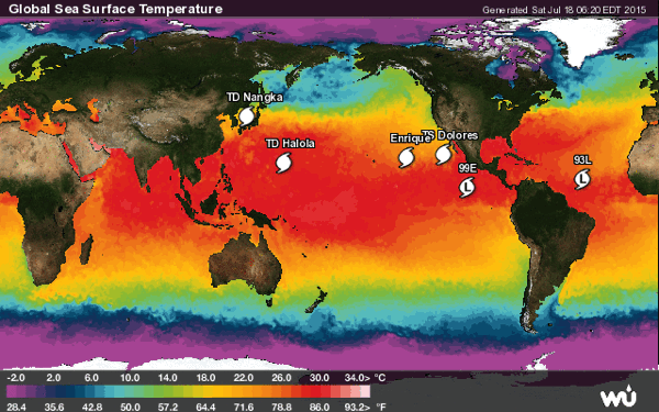
Tropical Depression 11w (Nangka), located approximately 289 nm west-southwest of Misawa, Japan, is tracking north-northeastward at 10 knots.
Tropical Storm Nangka kills 2, injures 38 in Japan — 550,000 told to flee.
Tropical Depression Halola is located about 03 nm east-southeast of Iwo To, and is tracking west-southwestward at 06 knots.
Tropical Storm Dolores is located about 380 mi...610 km WSW of Cabo San Lazaro Mexico with maximum sustained winds...45 mph...75 km/h. Present movement...WNW or 290 degrees at 10 mph...17 km/h.
Post-Tropical Cyclone Enrique is located about 1765 mi...2840 km W of the southern tip of Baja California with maximum sustained winds...35 mph...55 km/h. Present movement...SW or 225 degrees at 2 mph...4 km/h.
Invest 93L is an area of disturbed weather in the North Atlantic that has the potential for tropical development.
Invest 99E is an area of disturbed weather in the East Pacific that has the potential for tropical development.
NewsBytes:
Hertfordshire, England - Flash floods hit Hertfordshire homes after overnight storms. Roads were closed and firefighters were called to more than 141 incidents after heavy rain hit Hertfordshire.
No comments:
Post a Comment